Property Record
10301 Highway 45, Fort Smith, AR 72916

NEARBY LISTINGS FOR SALE OR LEASE
Property Detail
10301 Highway 45
60001-0000-05673-01
14-07-32
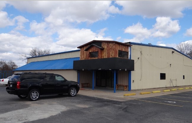
Restaurantbuilding
PT NW SE
A
Sebastian
05131C0120F
Arkansas
2025
11.93 AC
2025
Greater Ft Smith
001306
Fort Smith
9,044 SF
Fort Smith, AR-OK
DEMOGRAPHICS near 10301 Highway 45
1 Mile
3 Mile
5 Mile
2024 Total Population
1,118
18,744
44,554
2029 Population
1,133
19,018
45,402
Pop Growth 2024-2029
+ 1.34%
+ 1.46%
+ 1.90%
Average Age
44
41
40
2024 Total Households
441
7,903
18,747
HH Growth 2024-2029
+ 1.13%
+ 1.49%
+ 1.94%
Median Household Inc
$101,287
$65,380
$57,513
Avg Household Size
2.50
2.30
2.30
2024 Avg HH Vehicles
2.00
2.00
2.00
Median Home Value
$219,658
$195,582
$181,689
Median Year Built
1992
1991
1986
Nearby Places
Map Layers
Map Styles
 Street
 Aerial
- Restaurants
- Banks
- Shops
- Fitness
- Groceries
PUBLIC TRANSPORTATION
AIRPORT
Fort Smith Regional
DRIVE
WALK
Distance
Fort Smith Regional
16 min
7.0 mi
SALE & LEASE HISTORY
LISTING DATE
SALE/LEASE

Sep 25, 2016
For Lease
Sep 23, 2016
For Sale
Apr 12, 2017
For Sale
Nearby Properties
Address
Land Use
TOTAL SIZE
Lot Size
Zoning
Address
Land Use
TOTAL SIZE
Lot Size
Zoning
124,455 SF
38.09 AC
Address
Land Use
TOTAL SIZE
Lot Size
Zoning
364,749 SF
32.41 AC
Address
Land Use
TOTAL SIZE
Lot Size
Zoning
212,590 SF
30.06 AC
Address
Land Use
TOTAL SIZE
Lot Size
Zoning
208,886 SF
212.42 AC
Address
Land Use
TOTAL SIZE
Lot Size
Zoning
342,092 SF
12.15 AC
Address
Land Use
TOTAL SIZE
Lot Size
Zoning
847,154 SF
66.34 AC
Address
Land Use
TOTAL SIZE
Lot Size
Zoning
21,556 SF
47 AC
Address
Land Use
TOTAL SIZE
Lot Size
Zoning
205,000 SF
30 AC
Address
Land Use
TOTAL SIZE
Lot Size
Zoning
13,911 SF
25.40 AC
Address
Land Use
TOTAL SIZE
Lot Size
Zoning
356,451 SF
44.13 AC
Address
Land Use
TOTAL SIZE
Lot Size
Zoning
242,000 SF
10.62 AC
Address
Land Use
TOTAL SIZE
Lot Size
Zoning
89,157 SF
15.84 AC
Address
Land Use
TOTAL SIZE
Lot Size
Zoning
613,600 SF
54.46 AC
Address
Land Use
TOTAL SIZE
Lot Size
Zoning
419,250 SF
22.86 AC
Address
Land Use
TOTAL SIZE
Lot Size
Zoning
418,608 SF
27.04 AC
Address
Land Use
TOTAL SIZE
Lot Size
Zoning
29,522 SF
25 AC
Address
Land Use
TOTAL SIZE
Lot Size
Zoning
105.25 AC
Address
Land Use
TOTAL SIZE
Lot Size
Zoning
106,455 SF
5 AC
Address
Land Use
TOTAL SIZE
Lot Size
Zoning
61,881 SF
8.89 AC
Address
Land Use
TOTAL SIZE
Lot Size
Zoning
147,360 SF
20.71 AC
Address
Land Use
TOTAL SIZE
Lot Size
Zoning
168,195 SF
33.51 AC
Address
Land Use
TOTAL SIZE
Lot Size
Zoning
87,003 SF
5.29 AC
Address
Land Use
TOTAL SIZE
Lot Size
Zoning
111,684 SF
19.56 AC
Address
Land Use
TOTAL SIZE
Lot Size
Zoning
90,000 SF
7.93 AC
Address
Land Use
TOTAL SIZE
Lot Size
Zoning
145,467 SF
15.14 AC
Address
Land Use
TOTAL SIZE
Lot Size
Zoning
80,847 SF
38.07 AC
Address
Land Use
TOTAL SIZE
Lot Size
Zoning
105,410 SF
11.02 AC
Address
Land Use
TOTAL SIZE
Lot Size
Zoning
13,637 SF
6.74 AC
Address
Land Use
TOTAL SIZE
Lot Size
Zoning
40,551 SF
5 AC
Address
Land Use
TOTAL SIZE
Lot Size
Zoning
35,527 SF
10.19 AC
The World's #1 Commercial Real Estate Marketplace
Connect with us
© 2026 CoStar Group
The information above has been obtained from sources believed reliable. While we do not doubt its accuracy we have not verified it and make no guarantee, warranty or representation about it. It is your responsibility to independently confirm its accuracy and completeness. Any projections, opinions, assumptions, or estimates used are for example only and do not represent the current or future performance of the property. The value of this transaction to you depends on tax and other factors which should be evaluated by your tax, financial, and legal advisors. You and your advisors should conduct a careful, independent investigation of the property to determine to your satisfaction the suitability of the property for your needs.