Property Record
1031 Bud Pogue Way, , KY
NEARBY LISTINGS FOR SALE OR LEASE
Property Detail
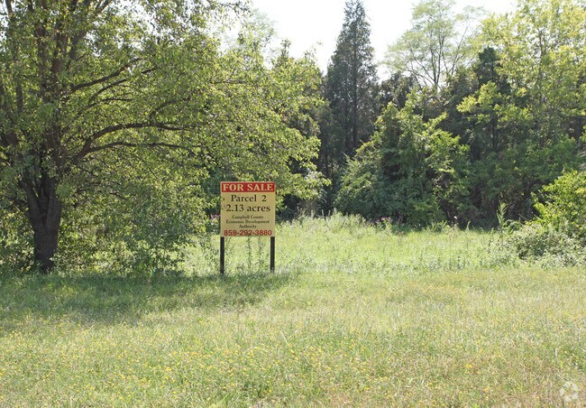
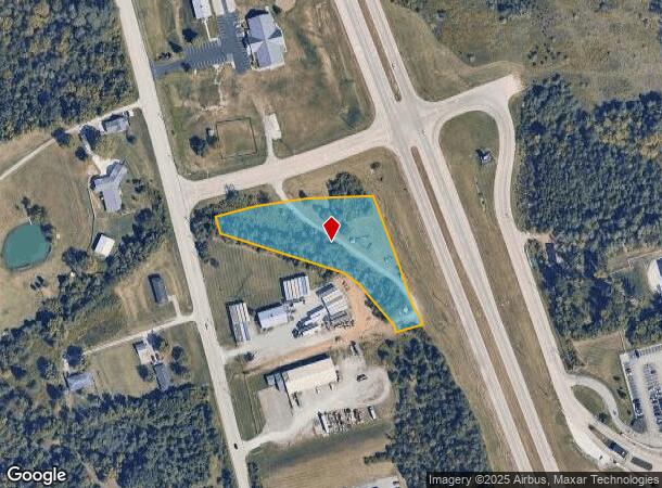
1031 Bud Pogue Way
Cincinnati, OH-KY-IN
So Camp Co Industrial Park
999-99-35-473.00
SOUTHERN CAMPBELL CO INDUSTRIAL PARK SEC 1 RESUB PT LOT 1 2.132 AC REMAINDER
Commercialnec
Campbell
X
Kentucky
21037C0092E
1-2
0
2.13 AC
2025
Outlying N Kentucky
051904
Cincinnati/Dayton
DEMOGRAPHICS near 1031 Bud Pogue Way
1 Mile
3 Mile
5 Mile
2024 Total Population
1,391
8,369
21,046
2029 Population
1,391
8,372
21,202
Pop Growth 2024-2029
0.00%
+ 0.04%
+ 0.74%
Average Age
40
40
41
2024 Total Households
511
2,932
7,628
HH Growth 2024-2029
0.00%
(0.10%)
+ 0.73%
Median Household Inc
$94,301
$101,336
$97,258
Avg Household Size
2.70
2.80
2.70
2024 Avg HH Vehicles
2.00
2.00
2.00
Median Home Value
$228,344
$247,484
$251,023
Median Year Built
1989
1991
1990
Nearby Places
Map Layers
Map Styles
 Street
 Aerial
- Restaurants
- Banks
- Shops
- Fitness
- Groceries
PUBLIC TRANSPORTATION
AIRPORT
Cincinnati/Northern Kentucky International
DRIVE
WALK
Distance
Cincinnati/Northern Kentucky International
40 min
23.1 mi
Freight Ports
Port of Toledo
DRIVE
WALK
Distance
Port of Toledo
268 min
220.5 mi
SALE & LEASE HISTORY
LISTING DATE
SALE/LEASE

Sep 24, 2016
For Sale
Nearby Properties
Address
Land Use
TOTAL SIZE
Lot Size
Zoning
Address
Land Use
TOTAL SIZE
Lot Size
Zoning
336,060 SF
61.32 AC
Address
Land Use
TOTAL SIZE
Lot Size
Zoning
217,080 SF
45.14 AC
Address
Land Use
TOTAL SIZE
Lot Size
Zoning
79,696 SF
18.96 AC
Address
Land Use
TOTAL SIZE
Lot Size
Zoning
2,952 SF
18.46 AC
Address
Land Use
TOTAL SIZE
Lot Size
Zoning
30,086 SF
4.99 AC
Address
Land Use
TOTAL SIZE
Lot Size
Zoning
40.01 AC
Address
Land Use
TOTAL SIZE
Lot Size
Zoning
13,137 SF
2.09 AC
Address
Land Use
TOTAL SIZE
Lot Size
Zoning
6,000 SF
1.07 AC
Address
Land Use
TOTAL SIZE
Lot Size
Zoning
9,100 SF
1.91 AC
Address
Land Use
TOTAL SIZE
Lot Size
Zoning
3,465 SF
1.01 AC
Address
Land Use
TOTAL SIZE
Lot Size
Zoning
2,268 SF
5.94 AC
Address
Land Use
TOTAL SIZE
Lot Size
Zoning
80.94 AC
Address
Land Use
TOTAL SIZE
Lot Size
Zoning
4,192 SF
1.39 AC
Address
Land Use
TOTAL SIZE
Lot Size
Zoning
720 SF
3.75 AC
Address
Land Use
TOTAL SIZE
Lot Size
Zoning
0.04 AC
Address
Land Use
TOTAL SIZE
Lot Size
Zoning
0.04 AC
Address
Land Use
TOTAL SIZE
Lot Size
Zoning
0.04 AC
Address
Land Use
TOTAL SIZE
Lot Size
Zoning
0.04 AC
Address
Land Use
TOTAL SIZE
Lot Size
Zoning
0.04 AC
Address
Land Use
TOTAL SIZE
Lot Size
Zoning
11,060 SF
1.58 AC
Address
Land Use
TOTAL SIZE
Lot Size
Zoning
0.04 AC
Address
Land Use
TOTAL SIZE
Lot Size
Zoning
0.04 AC
Address
Land Use
TOTAL SIZE
Lot Size
Zoning
17,789 SF
2.02 AC
Address
Land Use
TOTAL SIZE
Lot Size
Zoning
17,587 SF
7.60 AC
Address
Land Use
TOTAL SIZE
Lot Size
Zoning
0.04 AC
Address
Land Use
TOTAL SIZE
Lot Size
Zoning
0.04 AC
Address
Land Use
TOTAL SIZE
Lot Size
Zoning
0.04 AC
Address
Land Use
TOTAL SIZE
Lot Size
Zoning
0.04 AC
Address
Land Use
TOTAL SIZE
Lot Size
Zoning
0.04 AC
Address
Land Use
TOTAL SIZE
Lot Size
Zoning
0.04 AC
The World's #1 Commercial Real Estate Marketplace
Connect with us
© 2025 CoStar Group
The information above has been obtained from sources believed reliable. While we do not doubt its accuracy we have not verified it and make no guarantee, warranty or representation about it. It is your responsibility to independently confirm its accuracy and completeness. Any projections, opinions, assumptions, or estimates used are for example only and do not represent the current or future performance of the property. The value of this transaction to you depends on tax and other factors which should be evaluated by your tax, financial, and legal advisors. You and your advisors should conduct a careful, independent investigation of the property to determine to your satisfaction the suitability of the property for your needs.