Property Record
1031 Us Highway 202 N, Branchburg, NJ 08876
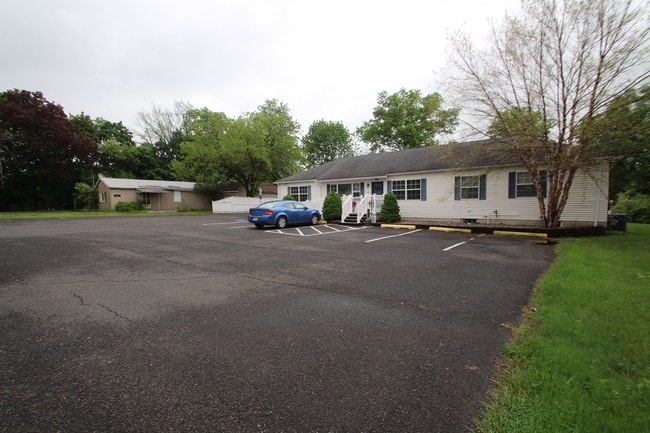
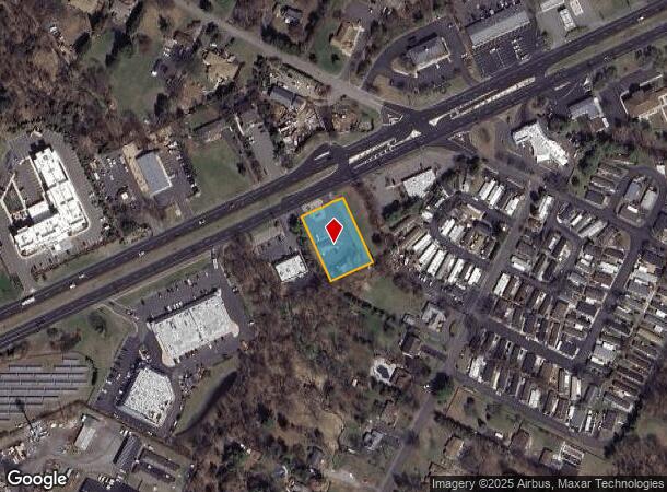
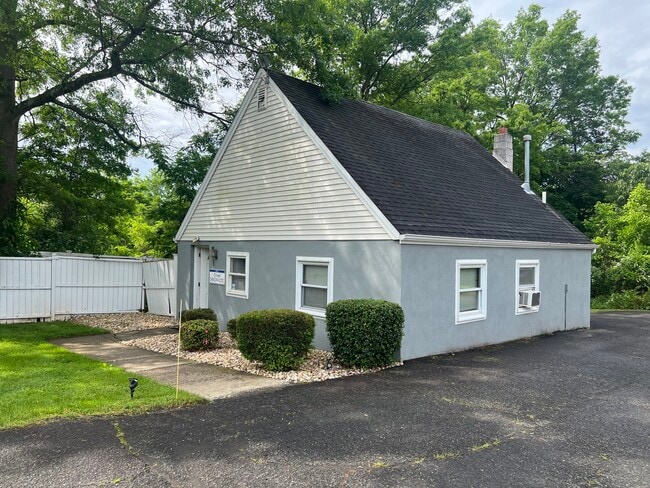

This Property Is For Sale
NEARBY LISTINGS FOR SALE OR LEASE
Property Detail
1031 Us Highway 202 N
Newark, NJ-PA
Robbins-Hockenbury
05-00057-0000-00005
ADDITIONAL LOTS: 1687+663=2350
Officebuilding
Somerset
X
New Jersey
34019C0279F
5
2024
0.57 AC
2025
Route 22 West
053603
Northern New Jersey
DEMOGRAPHICS near 1031 Us Highway 202 N
1 Mile
3 Mile
5 Mile
2024 Total Population
2,921
35,011
93,292
2029 Population
2,911
35,051
93,695
Pop Growth 2024-2029
(0.34%)
+ 0.11%
+ 0.43%
Average Age
44
42
42
2024 Total Households
1,191
12,728
34,835
HH Growth 2024-2029
(0.42%)
+ 0.02%
+ 0.46%
Median Household Inc
$131,507
$148,683
$130,133
Avg Household Size
2.40
2.70
2.60
2024 Avg HH Vehicles
2.00
2.00
2.00
Median Home Value
$438,444
$492,516
$465,701
Median Year Built
1987
1987
1982
Nearby Places
- Restaurants
- Banks
- Shops
- Fitness
- Groceries
PUBLIC TRANSPORTATION
COMMUTER RAIL
North Branch (Raritan Valley Line - NJ Transit Commuter Rail (NJ Transit))
DRIVE
WALK
Distance
North Branch (Raritan Valley Line - NJ Transit Commuter Rail (NJ Transit))
8 min
2.4 mi
Raritan (Raritan Valley Line - NJ Transit Commuter Rail (NJ Transit))
DRIVE
WALK
Distance
Raritan (Raritan Valley Line - NJ Transit Commuter Rail (NJ Transit))
6 min
3.5 mi
AIRPORT
Trenton Mercer
DRIVE
WALK
Distance
Trenton Mercer
47 min
29.2 mi
Newark Liberty International
DRIVE
WALK
Distance
Newark Liberty International
47 min
37.6 mi
Freight Ports
New York Container Terminal
DRIVE
WALK
Distance
New York Container Terminal
48 min
36.7 mi
Nearby Properties
Address
Land Use
TOTAL SIZE
Lot Size
Zoning
Address
Land Use
TOTAL SIZE
Lot Size
Zoning
63.86 AC
I2
Address
Land Use
TOTAL SIZE
Lot Size
Zoning
108.74 AC
OM-3
Address
Land Use
TOTAL SIZE
Lot Size
Zoning
29.74 AC
I-2
Address
Land Use
TOTAL SIZE
Lot Size
Zoning
47.50 AC
M1
Address
Land Use
TOTAL SIZE
Lot Size
Zoning
4,397 SF
26.86 AC
I-1
Address
Land Use
TOTAL SIZE
Lot Size
Zoning
28.76 AC
I-IP
Address
Land Use
TOTAL SIZE
Lot Size
Zoning
54.31 AC
P-2
Address
Land Use
TOTAL SIZE
Lot Size
Zoning
25.70 AC
PACD
Address
Land Use
TOTAL SIZE
Lot Size
Zoning
66.08 AC
M3
Address
Land Use
TOTAL SIZE
Lot Size
Zoning
34.80 AC
OM-3
Address
Land Use
TOTAL SIZE
Lot Size
Zoning
33.16 AC
M3
Address
Land Use
TOTAL SIZE
Lot Size
Zoning
24.04 AC
RMU
Address
Land Use
TOTAL SIZE
Lot Size
Zoning
1,056 SF
0.07 AC
Address
Land Use
TOTAL SIZE
Lot Size
Zoning
25 SF
10.43 AC
M2
Address
Land Use
TOTAL SIZE
Lot Size
Zoning
10.33 AC
I-2
Address
Land Use
TOTAL SIZE
Lot Size
Zoning
20 AC
I-1
Address
Land Use
TOTAL SIZE
Lot Size
Zoning
12.58 AC
I-2
Address
Land Use
TOTAL SIZE
Lot Size
Zoning
38.79 AC
I-1
Address
Land Use
TOTAL SIZE
Lot Size
Zoning
23.64 AC
I,IP
Address
Land Use
TOTAL SIZE
Lot Size
Zoning
13.48 AC
I2
Address
Land Use
TOTAL SIZE
Lot Size
Zoning
20.18 AC
I-1
Address
Land Use
TOTAL SIZE
Lot Size
Zoning
25.08 AC
I-1
Address
Land Use
TOTAL SIZE
Lot Size
Zoning
10.34 AC
RS-1
Address
Land Use
TOTAL SIZE
Lot Size
Zoning
14.68 AC
C3
Address
Land Use
TOTAL SIZE
Lot Size
Zoning
25.25 AC
I2
Address
Land Use
TOTAL SIZE
Lot Size
Zoning
12.05 AC
I-IP
Address
Land Use
TOTAL SIZE
Lot Size
Zoning
23.11 AC
I-1
Address
Land Use
TOTAL SIZE
Lot Size
Zoning
5.98 AC
I-IP
Address
Land Use
TOTAL SIZE
Lot Size
Zoning
22.84 AC
I-1
Address
Land Use
TOTAL SIZE
Lot Size
Zoning
13.99 AC
I-2
The World's #1 Commercial Real Estate Marketplace
Connect with us
© 2025 CoStar Group
The information above has been obtained from sources believed reliable. While we do not doubt its accuracy we have not verified it and make no guarantee, warranty or representation about it. It is your responsibility to independently confirm its accuracy and completeness. Any projections, opinions, assumptions, or estimates used are for example only and do not represent the current or future performance of the property. The value of this transaction to you depends on tax and other factors which should be evaluated by your tax, financial, and legal advisors. You and your advisors should conduct a careful, independent investigation of the property to determine to your satisfaction the suitability of the property for your needs.