Property Record
1032 Trexlertown Rd, Breinigsville, PA 18031
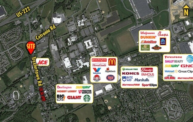
NEARBY LISTINGS FOR SALE OR LEASE
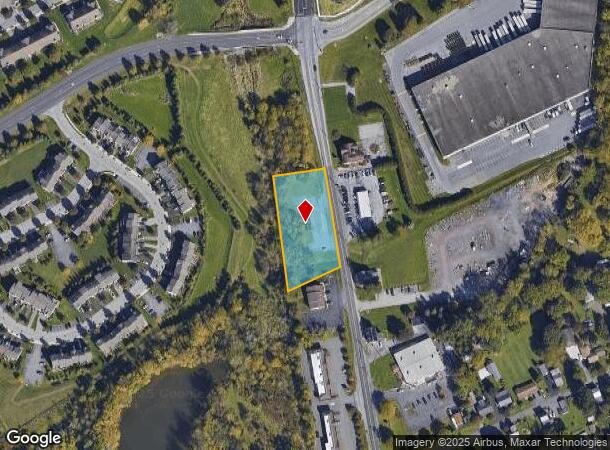
Property Detail
1032 Trexlertown Rd
546531659533-1
LOTS: 014
Storebuilding
Lehigh
A
Pennsylvania
42011C0250G
14
2025
1.15 AC
2025
Lehigh Valley
006206
Philadelphia
320 SF
Allentown-Bethlehem-Easton, PA-NJ
DEMOGRAPHICS near 1032 Trexlertown Rd
1 Mile
3 Mile
5 Mile
2024 Total Population
4,596
39,105
84,123
2029 Population
4,803
39,377
84,732
Pop Growth 2024-2029
+ 4.50%
+ 0.70%
+ 0.72%
Average Age
39
40
42
2024 Total Households
1,808
14,282
32,032
HH Growth 2024-2029
+ 4.70%
+ 0.71%
+ 0.72%
Median Household Inc
$71,860
$101,253
$98,882
Avg Household Size
2.50
2.70
2.60
2024 Avg HH Vehicles
2.00
2.00
2.00
Median Home Value
$235,650
$311,121
$325,624
Median Year Built
2003
1997
1990
Nearby Places
Map Layers
Map Styles
 Street
 Aerial
- Restaurants
- Banks
- Shops
- Fitness
- Groceries
PUBLIC TRANSPORTATION
AIRPORT
Lehigh Valley International
DRIVE
WALK
Distance
Lehigh Valley International
22 min
14.2 mi
Freight Ports
Port of Philadelphia
DRIVE
WALK
Distance
Port of Philadelphia
80 min
62.5 mi
SALE & LEASE HISTORY
LISTING DATE
SALE/LEASE

Aug 17, 2021
For Sale
Nearby Properties
Address
Land Use
TOTAL SIZE
Lot Size
Zoning
Address
Land Use
TOTAL SIZE
Lot Size
Zoning
474,892 SF
33.35 AC
L1-L
Address
Land Use
TOTAL SIZE
Lot Size
Zoning
1,155,164 SF
101.05 AC
L1
Address
Land Use
TOTAL SIZE
Lot Size
Zoning
1,042,665 SF
86 AC
LI
Address
Land Use
TOTAL SIZE
Lot Size
Zoning
600,000 SF
72.02 AC
L1
Address
Land Use
TOTAL SIZE
Lot Size
Zoning
1,200,000 SF
77.38 AC
HI-S
Address
Land Use
TOTAL SIZE
Lot Size
Zoning
1,099,800 SF
70 AC
HI-S
Address
Land Use
TOTAL SIZE
Lot Size
Zoning
1,088,000 SF
70.68 AC
HI-S
Address
Land Use
TOTAL SIZE
Lot Size
Zoning
1,192,380 SF
83.59 AC
LI
Address
Land Use
TOTAL SIZE
Lot Size
Zoning
5,240 SF
137.34 AC
RT
Address
Land Use
TOTAL SIZE
Lot Size
Zoning
927,980 SF
58.81 AC
HI-S
Address
Land Use
TOTAL SIZE
Lot Size
Zoning
685,920 SF
83.33 AC
LI
Address
Land Use
TOTAL SIZE
Lot Size
Zoning
999,600 SF
67.99 AC
LI
Address
Land Use
TOTAL SIZE
Lot Size
Zoning
12,545 SF
84.20 AC
LI
Address
Land Use
TOTAL SIZE
Lot Size
Zoning
4,990 SF
39.62 AC
R5
Address
Land Use
TOTAL SIZE
Lot Size
Zoning
920,400 SF
65.34 AC
LI
Address
Land Use
TOTAL SIZE
Lot Size
Zoning
789,551 SF
52.39 AC
LI
Address
Land Use
TOTAL SIZE
Lot Size
Zoning
822,162 SF
50.12 AC
LI
Address
Land Use
TOTAL SIZE
Lot Size
Zoning
730,080 SF
44.34 AC
Address
Land Use
TOTAL SIZE
Lot Size
Zoning
730,080 SF
44.96 AC
Address
Land Use
TOTAL SIZE
Lot Size
Zoning
794,880 SF
45.63 AC
LI
Address
Land Use
TOTAL SIZE
Lot Size
Zoning
651,393 SF
71.96 AC
HI-S
Address
Land Use
TOTAL SIZE
Lot Size
Zoning
573,344 SF
38.61 AC
LI
Address
Land Use
TOTAL SIZE
Lot Size
Zoning
480,000 SF
27.94 AC
LI
Address
Land Use
TOTAL SIZE
Lot Size
Zoning
610,647 SF
46.50 AC
LI
Address
Land Use
TOTAL SIZE
Lot Size
Zoning
19,055 SF
194.07 AC
LI
Address
Land Use
TOTAL SIZE
Lot Size
Zoning
725,760 SF
50.25 AC
LI
Address
Land Use
TOTAL SIZE
Lot Size
Zoning
698,350 SF
42.82 AC
O
Address
Land Use
TOTAL SIZE
Lot Size
Zoning
4,037 SF
30.51 AC
R5
Address
Land Use
TOTAL SIZE
Lot Size
Zoning
808,418 SF
65.50 AC
LI
Address
Land Use
TOTAL SIZE
Lot Size
Zoning
607,320 SF
53.44 AC
LI
The World's #1 Commercial Real Estate Marketplace
Connect with us
© 2025 CoStar Group
The information above has been obtained from sources believed reliable. While we do not doubt its accuracy we have not verified it and make no guarantee, warranty or representation about it. It is your responsibility to independently confirm its accuracy and completeness. Any projections, opinions, assumptions, or estimates used are for example only and do not represent the current or future performance of the property. The value of this transaction to you depends on tax and other factors which should be evaluated by your tax, financial, and legal advisors. You and your advisors should conduct a careful, independent investigation of the property to determine to your satisfaction the suitability of the property for your needs.