Property Record
10320 Maple Ridge Rd, Middleport, NY 14105
NEARBY LISTINGS FOR SALE OR LEASE
-
-
View all Middleport listings for sale on LoopNet.com
Property Detail
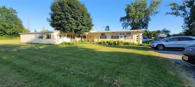
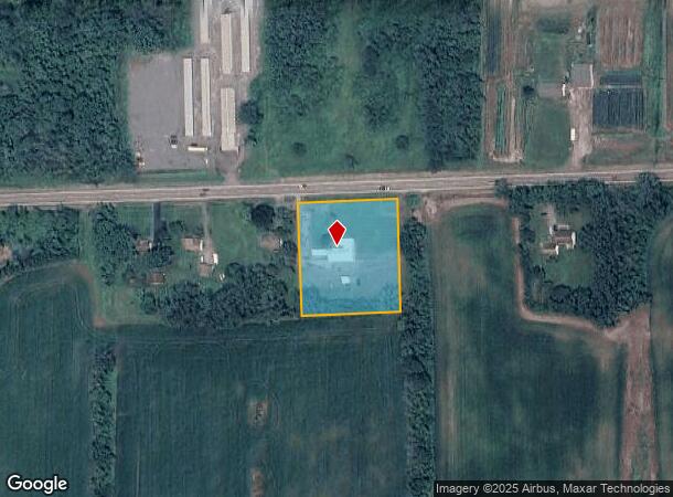
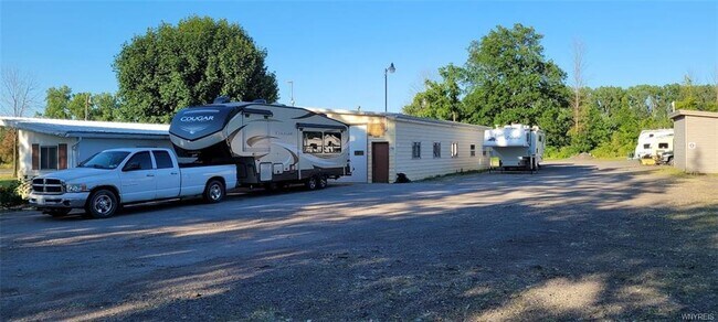
10320 Maple Ridge Rd
343689-089-000-0001-007-001
PT LT39 T14 R4 HLC TRAILER SALES
Vehiclerentalsvehiclesales
Orleans
X
New York
36073C0255D
7.001
2025
1.74 AC
2024
Orleans County
040300
Rochester
3,216 SF
Rochester, NY
DEMOGRAPHICS near 10320 Maple Ridge Rd
1 Mile
3 Mile
5 Mile
2024 Total Population
316
4,095
12,320
2029 Population
307
3,997
12,029
Pop Growth 2024-2029
(2.85%)
(2.39%)
(2.36%)
Average Age
42
42
42
2024 Total Households
133
1,727
5,170
HH Growth 2024-2029
(3.01%)
(2.43%)
(2.38%)
Median Household Inc
$65,192
$62,072
$59,576
Avg Household Size
2.40
2.40
2.30
2024 Avg HH Vehicles
2.00
2.00
2.00
Median Home Value
$140,000
$132,040
$118,944
Median Year Built
1948
1948
1948
Nearby Places
- Restaurants
- Banks
- Shops
- Fitness
- Groceries
PUBLIC TRANSPORTATION
AIRPORT
Niagara Falls International
DRIVE
WALK
Distance
Niagara Falls International
39 min
28.7 mi
Buffalo Niagara International
DRIVE
WALK
Distance
Buffalo Niagara International
41 min
30.0 mi
Freight Ports
Albany, NY Port
DRIVE
WALK
Distance
Albany, NY Port
323 min
274.6 mi
SALE & LEASE HISTORY
LISTING DATE
SALE/LEASE

Jun 30, 2022
For Sale
Nearby Properties
Address
Land Use
TOTAL SIZE
Lot Size
Zoning
Address
Land Use
TOTAL SIZE
Lot Size
Zoning
114,038 SF
65.10 AC
01 - NOT Z
Address
Land Use
TOTAL SIZE
Lot Size
Zoning
82,664 SF
24.40 AC
R1
Address
Land Use
TOTAL SIZE
Lot Size
Zoning
Address
Land Use
TOTAL SIZE
Lot Size
Zoning
66,080 SF
0.01 AC
05 - COMME
Address
Land Use
TOTAL SIZE
Lot Size
Zoning
Address
Land Use
TOTAL SIZE
Lot Size
Zoning
65,059 SF
10.44 AC
RA
Address
Land Use
TOTAL SIZE
Lot Size
Zoning
330,360 SF
19 AC
Address
Land Use
TOTAL SIZE
Lot Size
Zoning
Address
Land Use
TOTAL SIZE
Lot Size
Zoning
2,800 SF
37.95 AC
05
Address
Land Use
TOTAL SIZE
Lot Size
Zoning
113,002 SF
13.92 AC
I1
Address
Land Use
TOTAL SIZE
Lot Size
Zoning
42.60 AC
Address
Land Use
TOTAL SIZE
Lot Size
Zoning
17 AC
Address
Land Use
TOTAL SIZE
Lot Size
Zoning
Address
Land Use
TOTAL SIZE
Lot Size
Zoning
82,300 SF
4.30 AC
06 - INDUS
Address
Land Use
TOTAL SIZE
Lot Size
Zoning
1,440 SF
15.40 AC
07 - MIXED
Address
Land Use
TOTAL SIZE
Lot Size
Zoning
39,516 SF
44.90 AC
I
Address
Land Use
TOTAL SIZE
Lot Size
Zoning
Address
Land Use
TOTAL SIZE
Lot Size
Zoning
Address
Land Use
TOTAL SIZE
Lot Size
Zoning
37,536 SF
23.90 AC
05 - COMME
Address
Land Use
TOTAL SIZE
Lot Size
Zoning
19,545 SF
0.01 AC
Address
Land Use
TOTAL SIZE
Lot Size
Zoning
Address
Land Use
TOTAL SIZE
Lot Size
Zoning
Address
Land Use
TOTAL SIZE
Lot Size
Zoning
420.90 AC
RES/AG
Address
Land Use
TOTAL SIZE
Lot Size
Zoning
165,700 SF
9 AC
06
Address
Land Use
TOTAL SIZE
Lot Size
Zoning
324.64 AC
Address
Land Use
TOTAL SIZE
Lot Size
Zoning
Address
Land Use
TOTAL SIZE
Lot Size
Zoning
3,830 SF
0.98 AC
C
Address
Land Use
TOTAL SIZE
Lot Size
Zoning
Address
Land Use
TOTAL SIZE
Lot Size
Zoning
Address
Land Use
TOTAL SIZE
Lot Size
Zoning
90,040 SF
17.86 AC
The World's #1 Commercial Real Estate Marketplace
Connect with us
© 2025 CoStar Group
The information above has been obtained from sources believed reliable. While we do not doubt its accuracy we have not verified it and make no guarantee, warranty or representation about it. It is your responsibility to independently confirm its accuracy and completeness. Any projections, opinions, assumptions, or estimates used are for example only and do not represent the current or future performance of the property. The value of this transaction to you depends on tax and other factors which should be evaluated by your tax, financial, and legal advisors. You and your advisors should conduct a careful, independent investigation of the property to determine to your satisfaction the suitability of the property for your needs.