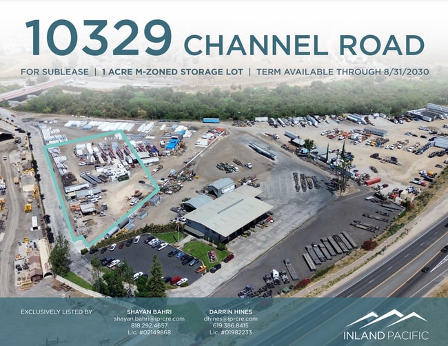
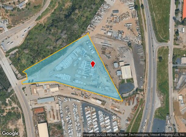
Property Record
10321 Channel Rd, Lakeside, CA 92040
Current Lease Availabilities
NEARBY LISTINGS FOR SALE OR LEASE
Property Detail
10321 Channel Rd
San Diego-Chula Vista-Carlsbad, CA
El Cajon Valley Cos Lands
392-090-31
LOT 62 THAT POR OF DOC88-260024 IN STS CLSD&IN TR 000289
Industrialacreage
San Diego
AE
California
06073C1656G
62
2024
7.84 AC
2025
East County
016804
San Diego
DEMOGRAPHICS near 10321 Channel Rd
1 Mile
3 Mile
5 Mile
2024 Total Population
13,251
67,964
158,663
2029 Population
13,388
66,980
155,700
Pop Growth 2024-2029
+ 1.03%
(1.45%)
(1.87%)
Average Age
38
40
39
2024 Total Households
4,703
23,459
53,886
HH Growth 2024-2029
+ 0.68%
(1.74%)
(2.17%)
Median Household Inc
$72,591
$94,602
$81,232
Avg Household Size
2.70
2.80
2.80
2024 Avg HH Vehicles
2.00
2.00
2.00
Median Home Value
$627,286
$660,366
$644,937
Median Year Built
1978
1978
1976
Nearby Places
Map Layers
Map Styles
 Street
 Aerial
- Restaurants
- Banks
- Shops
- Fitness
- Groceries
PUBLIC TRANSPORTATION
AIRPORT
San Diego International
DRIVE
WALK
Distance
San Diego International
31 min
22.8 mi
Freight Ports
Port of San Diego
DRIVE
WALK
Distance
Port of San Diego
29 min
21.7 mi
Nearby Properties
Address
Land Use
TOTAL SIZE
Lot Size
Zoning
Address
Land Use
TOTAL SIZE
Lot Size
Zoning
5.77 AC
RU
Address
Land Use
TOTAL SIZE
Lot Size
Zoning
10.23 AC
R22
Address
Land Use
TOTAL SIZE
Lot Size
Zoning
38.80 AC
RMH8
Address
Land Use
TOTAL SIZE
Lot Size
Zoning
4.93 AC
C36
Address
Land Use
TOTAL SIZE
Lot Size
Zoning
4.75 AC
C-6
Address
Land Use
TOTAL SIZE
Lot Size
Zoning
79,662 SF
8.21 AC
S88
Address
Land Use
TOTAL SIZE
Lot Size
Zoning
8.72 AC
R14
Address
Land Use
TOTAL SIZE
Lot Size
Zoning
4.61 AC
R7
Address
Land Use
TOTAL SIZE
Lot Size
Zoning
87,704 SF
3.74 AC
RU
Address
Land Use
TOTAL SIZE
Lot Size
Zoning
9.93 AC
S88
Address
Land Use
TOTAL SIZE
Lot Size
Zoning
90,405 SF
5.44 AC
IL
Address
Land Use
TOTAL SIZE
Lot Size
Zoning
57,840 SF
5.59 AC
R7
Address
Land Use
TOTAL SIZE
Lot Size
Zoning
7.66 AC
S88
Address
Land Use
TOTAL SIZE
Lot Size
Zoning
90,936 SF
3.70 AC
C34
Address
Land Use
TOTAL SIZE
Lot Size
Zoning
53,250 SF
5.28 AC
NC
Address
Land Use
TOTAL SIZE
Lot Size
Zoning
11,285 SF
2.81 AC
C37
Address
Land Use
TOTAL SIZE
Lot Size
Zoning
3,368 SF
33.63 AC
RMH6
Address
Land Use
TOTAL SIZE
Lot Size
Zoning
43,500 SF
3.79 AC
C34
Address
Land Use
TOTAL SIZE
Lot Size
Zoning
7.01 AC
RU
Address
Land Use
TOTAL SIZE
Lot Size
Zoning
30,086 SF
2.80 AC
GC
Address
Land Use
TOTAL SIZE
Lot Size
Zoning
53,357 SF
2.04 AC
C34
Address
Land Use
TOTAL SIZE
Lot Size
Zoning
78,759 SF
7.28 AC
IG
Address
Land Use
TOTAL SIZE
Lot Size
Zoning
78,577 SF
14.03 AC
M54
Address
Land Use
TOTAL SIZE
Lot Size
Zoning
74,018 SF
4.49 AC
R14
Address
Land Use
TOTAL SIZE
Lot Size
Zoning
6.95 AC
RU
Address
Land Use
TOTAL SIZE
Lot Size
Zoning
49,350 SF
4.32 AC
C36
Address
Land Use
TOTAL SIZE
Lot Size
Zoning
6.67 AC
RU
Address
Land Use
TOTAL SIZE
Lot Size
Zoning
4.87 AC
RU
Address
Land Use
TOTAL SIZE
Lot Size
Zoning
80.56 AC
S88
Address
Land Use
TOTAL SIZE
Lot Size
Zoning
73,485 SF
2.01 AC
R22
The World's #1 Commercial Real Estate Marketplace
Connect with us
© 2026 CoStar Group
The information above has been obtained from sources believed reliable. While we do not doubt its accuracy we have not verified it and make no guarantee, warranty or representation about it. It is your responsibility to independently confirm its accuracy and completeness. Any projections, opinions, assumptions, or estimates used are for example only and do not represent the current or future performance of the property. The value of this transaction to you depends on tax and other factors which should be evaluated by your tax, financial, and legal advisors. You and your advisors should conduct a careful, independent investigation of the property to determine to your satisfaction the suitability of the property for your needs.