Property Record
10321 Rebecca Creek Rd, Spring Branch, TX 78070
NEARBY LISTINGS FOR SALE OR LEASE
Property Detail
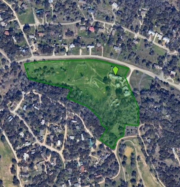
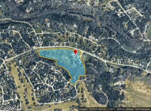
10321 Rebecca Creek Rd
74-0489-0014-01
A-489 Sur- 53 H Raisner
Agriculturalland
A-489 SUR- 53 H RAISNER, ACRES 13.792
X
Comal
48091C0090F
Texas
2024
13.79 AC
2025
Comal County
310610
San Antonio
2,232 SF
San Antonio-New Braunfels, TX
DEMOGRAPHICS near 10321 Rebecca Creek Rd
1 Mile
3 Mile
5 Mile
2024 Total Population
1,282
8,470
14,282
2029 Population
1,713
11,422
19,202
Pop Growth 2024-2029
+ 33.62%
+ 34.85%
+ 34.45%
Average Age
44
43
44
2024 Total Households
536
3,303
5,539
HH Growth 2024-2029
+ 33.21%
+ 34.67%
+ 34.32%
Median Household Inc
$67,302
$77,086
$82,205
Avg Household Size
2.40
2.50
2.50
2024 Avg HH Vehicles
2.00
2.00
2.00
Median Home Value
$185,377
$315,829
$380,342
Median Year Built
2006
2006
2006
Nearby Places
Map Layers
Map Styles
 Street
 Aerial
- Restaurants
- Banks
- Shops
- Fitness
- Groceries
PUBLIC TRANSPORTATION
AIRPORT
San Antonio International
DRIVE
WALK
Distance
San Antonio International
42 min
31.8 mi
Freight Ports
Calhoun Port
DRIVE
WALK
Distance
Calhoun Port
213 min
167.3 mi
Nearby Properties
Address
Land Use
TOTAL SIZE
Lot Size
Zoning
Address
Land Use
TOTAL SIZE
Lot Size
Zoning
334.47 AC
Address
Land Use
TOTAL SIZE
Lot Size
Zoning
17,400 SF
3.76 AC
Address
Land Use
TOTAL SIZE
Lot Size
Zoning
8,896 SF
3.19 AC
Address
Land Use
TOTAL SIZE
Lot Size
Zoning
1,728 SF
4.14 AC
Address
Land Use
TOTAL SIZE
Lot Size
Zoning
351.98 AC
Address
Land Use
TOTAL SIZE
Lot Size
Zoning
16,264 SF
21.01 AC
Address
Land Use
TOTAL SIZE
Lot Size
Zoning
13,162 SF
25.99 AC
Address
Land Use
TOTAL SIZE
Lot Size
Zoning
11,213 SF
7.26 AC
Address
Land Use
TOTAL SIZE
Lot Size
Zoning
12,968 SF
15.54 AC
Address
Land Use
TOTAL SIZE
Lot Size
Zoning
95.22 AC
Address
Land Use
TOTAL SIZE
Lot Size
Zoning
5,288 SF
133.02 AC
Address
Land Use
TOTAL SIZE
Lot Size
Zoning
13,488 SF
5.87 AC
Address
Land Use
TOTAL SIZE
Lot Size
Zoning
26,658 SF
31.10 AC
Address
Land Use
TOTAL SIZE
Lot Size
Zoning
3,584 SF
10.54 AC
Address
Land Use
TOTAL SIZE
Lot Size
Zoning
11,469 SF
206.85 AC
Address
Land Use
TOTAL SIZE
Lot Size
Zoning
117.42 AC
Address
Land Use
TOTAL SIZE
Lot Size
Zoning
10,000 SF
2.01 AC
Address
Land Use
TOTAL SIZE
Lot Size
Zoning
13,078 SF
1.22 AC
Address
Land Use
TOTAL SIZE
Lot Size
Zoning
2,240 SF
16.82 AC
Address
Land Use
TOTAL SIZE
Lot Size
Zoning
8,357 SF
15.47 AC
Address
Land Use
TOTAL SIZE
Lot Size
Zoning
2,800 SF
25.73 AC
Address
Land Use
TOTAL SIZE
Lot Size
Zoning
9,036 SF
0.98 AC
Address
Land Use
TOTAL SIZE
Lot Size
Zoning
5,109 SF
2.07 AC
Address
Land Use
TOTAL SIZE
Lot Size
Zoning
9,416 SF
3.47 AC
Address
Land Use
TOTAL SIZE
Lot Size
Zoning
9,760 SF
2.85 AC
Address
Land Use
TOTAL SIZE
Lot Size
Zoning
5,176 SF
14.23 AC
Address
Land Use
TOTAL SIZE
Lot Size
Zoning
465 SF
16.03 AC
Address
Land Use
TOTAL SIZE
Lot Size
Zoning
5,450 SF
17.74 AC
Address
Land Use
TOTAL SIZE
Lot Size
Zoning
2,276 SF
2.75 AC
The World's #1 Commercial Real Estate Marketplace
Connect with us
© 2025 CoStar Group
The information above has been obtained from sources believed reliable. While we do not doubt its accuracy we have not verified it and make no guarantee, warranty or representation about it. It is your responsibility to independently confirm its accuracy and completeness. Any projections, opinions, assumptions, or estimates used are for example only and do not represent the current or future performance of the property. The value of this transaction to you depends on tax and other factors which should be evaluated by your tax, financial, and legal advisors. You and your advisors should conduct a careful, independent investigation of the property to determine to your satisfaction the suitability of the property for your needs.