Property Record
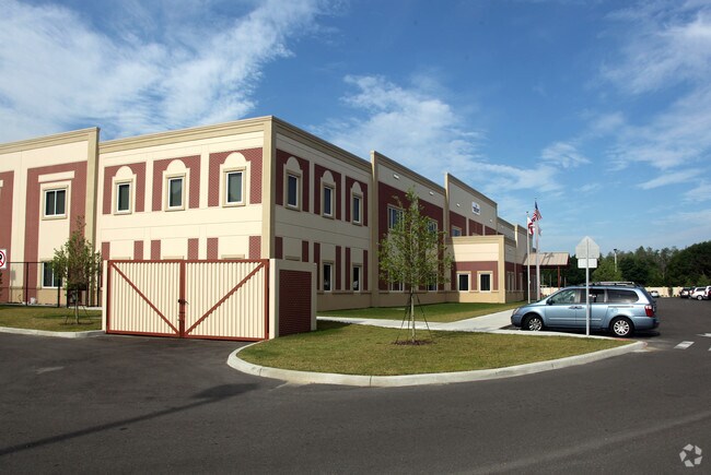
10322 Henderson Rd, Tampa, FL 33625


NEARBY LISTINGS FOR SALE OR LEASE
Property Detail
10322 Henderson Rd
Tampa-St. Petersburg-Clearwater, FL
Unplatted
U-13-28-17-ZZZ-000000-30650.0
THE EAST 1/2 OF THE SE 1/4 OF THE SE 1/4 LESS RD R/W
Privateschool
Hillsborough
X
Florida
12057C0191J
30650
2024
16.28 AC
2024
Northwest Tampa
011414
Tampa/St Petersburg
66,687 SF
DEMOGRAPHICS near 10322 Henderson Rd
1 Mile
3 Mile
5 Mile
2024 Total Population
8,465
106,318
258,094
2029 Population
9,171
115,255
280,092
Pop Growth 2024-2029
+ 8.34%
+ 8.41%
+ 8.52%
Average Age
40
41
40
2024 Total Households
3,247
41,249
102,320
HH Growth 2024-2029
+ 8.59%
+ 8.72%
+ 8.83%
Median Household Inc
$67,092
$65,119
$67,458
Avg Household Size
2.60
2.50
2.50
2024 Avg HH Vehicles
2.00
2.00
2.00
Median Home Value
$267,661
$281,551
$309,048
Median Year Built
1987
1985
1985
Nearby Places
Map Layers
Map Styles
 Street
 Aerial
- Restaurants
- Banks
- Shops
- Fitness
- Groceries
PUBLIC TRANSPORTATION
AIRPORT
Tampa International
DRIVE
WALK
Distance
Tampa International
16 min
8.6 mi
St Pete-Clearwater International
DRIVE
WALK
Distance
St Pete-Clearwater International
36 min
20.1 mi
Freight Ports
Port of Tampa Bay
DRIVE
WALK
Distance
Port of Tampa Bay
29 min
15.1 mi
Nearby Properties
Address
Land Use
TOTAL SIZE
Lot Size
Zoning
Address
Land Use
TOTAL SIZE
Lot Size
Zoning
596,669 SF
65.71 AC
PD
Address
Land Use
TOTAL SIZE
Lot Size
Zoning
457,731 SF
61.54 AC
PD
Address
Land Use
TOTAL SIZE
Lot Size
Zoning
467,085 SF
13.16 AC
PD
Address
Land Use
TOTAL SIZE
Lot Size
Zoning
318,025 SF
16.50 AC
PD
Address
Land Use
TOTAL SIZE
Lot Size
Zoning
423,639 SF
10.62 AC
PD
Address
Land Use
TOTAL SIZE
Lot Size
Zoning
284,123 SF
42.22 AC
RMC-20
Address
Land Use
TOTAL SIZE
Lot Size
Zoning
342,137 SF
72.73 AC
PD
Address
Land Use
TOTAL SIZE
Lot Size
Zoning
388,164 SF
29.38 AC
RMC-16
Address
Land Use
TOTAL SIZE
Lot Size
Zoning
238,535 SF
11.50 AC
PD
Address
Land Use
TOTAL SIZE
Lot Size
Zoning
384,891 SF
18.49 AC
PD
Address
Land Use
TOTAL SIZE
Lot Size
Zoning
403,548 SF
34.85 AC
RMC-12
Address
Land Use
TOTAL SIZE
Lot Size
Zoning
257,358 SF
19.09 AC
SPI-AP-5
Address
Land Use
TOTAL SIZE
Lot Size
Zoning
241,883 SF
29.88 AC
PD
Address
Land Use
TOTAL SIZE
Lot Size
Zoning
190,205 SF
15.02 AC
RMC-16
Address
Land Use
TOTAL SIZE
Lot Size
Zoning
707,554 SF
95.87 AC
PD
Address
Land Use
TOTAL SIZE
Lot Size
Zoning
199,564 SF
9.65 AC
PD
Address
Land Use
TOTAL SIZE
Lot Size
Zoning
249,953 SF
17.86 AC
PD
Address
Land Use
TOTAL SIZE
Lot Size
Zoning
178,877 SF
21.53 AC
PD
Address
Land Use
TOTAL SIZE
Lot Size
Zoning
197,535 SF
36.18 AC
PD
Address
Land Use
TOTAL SIZE
Lot Size
Zoning
156,020 SF
4.13 AC
PD
Address
Land Use
TOTAL SIZE
Lot Size
Zoning
196,483 SF
31.80 AC
CPV-C
Address
Land Use
TOTAL SIZE
Lot Size
Zoning
180,010 SF
11.22 AC
PD
Address
Land Use
TOTAL SIZE
Lot Size
Zoning
233,910 SF
17.95 AC
M
Address
Land Use
TOTAL SIZE
Lot Size
Zoning
292,496 SF
46.21 AC
RSC-9
Address
Land Use
TOTAL SIZE
Lot Size
Zoning
157,951 SF
12.07 AC
RMC-16
Address
Land Use
TOTAL SIZE
Lot Size
Zoning
199,843 SF
19.58 AC
CPV-P-1
Address
Land Use
TOTAL SIZE
Lot Size
Zoning
214,130 SF
28.59 AC
M
Address
Land Use
TOTAL SIZE
Lot Size
Zoning
108,557 SF
20.78 AC
PD
Address
Land Use
TOTAL SIZE
Lot Size
Zoning
165,689 SF
12.02 AC
PD
Address
Land Use
TOTAL SIZE
Lot Size
Zoning
433,047 SF
19.18 AC
PD
The World's #1 Commercial Real Estate Marketplace
Connect with us
© 2025 CoStar Group
The information above has been obtained from sources believed reliable. While we do not doubt its accuracy we have not verified it and make no guarantee, warranty or representation about it. It is your responsibility to independently confirm its accuracy and completeness. Any projections, opinions, assumptions, or estimates used are for example only and do not represent the current or future performance of the property. The value of this transaction to you depends on tax and other factors which should be evaluated by your tax, financial, and legal advisors. You and your advisors should conduct a careful, independent investigation of the property to determine to your satisfaction the suitability of the property for your needs.