Property Record
10325 E State Highway 33, Effingham, IL 62401


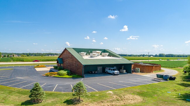
Property Detail
10325 E State Highway 33
1107011029
LOT 2 32-33 COMMERCIAL SUBD EXCEPT ROW 3681/188 2278/156 2249/38
Commercialnec
Effingham
B and X Area of moderate flood hazard, usually the area between the limits of the 100-year and 500-year floods.
Illinois
2024
2,32,33
2024
1.81 AC
950200
Other Market Areas
12,291 SF
Effingham, IL
NEARBY LISTINGS FOR SALE OR LEASE
-
-
View all Effingham listings for sale on LoopNet.com
DEMOGRAPHICS near 10325 E State Highway 33
1 mile
3 mile
5 mile
2025 Total Population
477
4,247
14,874
2030 Population
473
4,228
14,901
Pop Growth 2025-2030
(0.84%)
(0.45%)
+ 0.18%
Average Age
43
43
42
2025 Total Households
185
1,722
6,393
HH Growth 2025-2030
(0.54%)
(0.41%)
+ 0.19%
Median Household Inc
$113,020
$88,663
$77,359
Avg Household Size
2.50
2.40
2.20
2025 Avg HH Vehicles
2.00
2.00
2.00
Median Home Value
$352,857
$296,341
$212,488
Median Year Built
1985
1983
1977
Nearby Places
Map Layers
Map Styles
 Street
 Aerial
Layers
 Traffic
 Biking
Places
Listings with unknown addresses are not visible on the map
- Restaurants
- Banks
- Shops
- Fitness
- Groceries
PUBLIC TRANSPORTATION
COMMUTER RAIL
Drive
Walk
Distance
11 min
5.2 mi
SALE & LEASE HISTORY
LISTING DATE
SALE/LEASE

Aug 20, 2019
For Sale
Nearby Properties
Address
Land Use
TOTAL SIZE
Lot Size
Zoning
Address
Land Use
TOTAL SIZE
Lot Size
Zoning
224,208 SF
19.77 AC
Address
Land Use
TOTAL SIZE
Lot Size
Zoning
23,312 SF
14.48 AC
Address
Land Use
TOTAL SIZE
Lot Size
Zoning
80,075 SF
3.26 AC
Address
Land Use
TOTAL SIZE
Lot Size
Zoning
224,578 SF
20.96 AC
Address
Land Use
TOTAL SIZE
Lot Size
Zoning
65,712 SF
2.36 AC
Address
Land Use
TOTAL SIZE
Lot Size
Zoning
15,637 SF
2.19 AC
Address
Land Use
TOTAL SIZE
Lot Size
Zoning
52,260 SF
2.20 AC
Address
Land Use
TOTAL SIZE
Lot Size
Zoning
17,611 SF
15.97 AC
Address
Land Use
TOTAL SIZE
Lot Size
Zoning
49,524 SF
4.13 AC
Address
Land Use
TOTAL SIZE
Lot Size
Zoning
213,880 SF
45.80 AC
Address
Land Use
TOTAL SIZE
Lot Size
Zoning
20,328 SF
2.65 AC
Address
Land Use
TOTAL SIZE
Lot Size
Zoning
33,800 SF
6.86 AC
Address
Land Use
TOTAL SIZE
Lot Size
Zoning
30,157 SF
2.65 AC
Address
Land Use
TOTAL SIZE
Lot Size
Zoning
68,507 SF
5.91 AC
Address
Land Use
TOTAL SIZE
Lot Size
Zoning
37,212 SF
1.40 AC
Address
Land Use
TOTAL SIZE
Lot Size
Zoning
5,883 SF
1.70 AC
Address
Land Use
TOTAL SIZE
Lot Size
Zoning
10,428 SF
1.50 AC
Address
Land Use
TOTAL SIZE
Lot Size
Zoning
32,029 SF
21.09 AC
Address
Land Use
TOTAL SIZE
Lot Size
Zoning
7,268 SF
0.69 AC
Address
Land Use
TOTAL SIZE
Lot Size
Zoning
34,089 SF
1.77 AC
Address
Land Use
TOTAL SIZE
Lot Size
Zoning
17,573 SF
1.34 AC
Address
Land Use
TOTAL SIZE
Lot Size
Zoning
10,257 SF
1.24 AC
Address
Land Use
TOTAL SIZE
Lot Size
Zoning
27,988 SF
1.66 AC
Address
Land Use
TOTAL SIZE
Lot Size
Zoning
27,250 SF
4.01 AC
Address
Land Use
TOTAL SIZE
Lot Size
Zoning
14,244 SF
1.09 AC
Address
Land Use
TOTAL SIZE
Lot Size
Zoning
4,281 SF
1.16 AC
Address
Land Use
TOTAL SIZE
Lot Size
Zoning
11,105 SF
1.26 AC
Address
Land Use
TOTAL SIZE
Lot Size
Zoning
7,565 SF
9.73 AC
Address
Land Use
TOTAL SIZE
Lot Size
Zoning
4,683 SF
0.86 AC
Address
Land Use
TOTAL SIZE
Lot Size
Zoning
10,500 SF
3.61 AC
The World's #1 Commercial Real Estate Marketplace
Connect with us
© 2026 CoStar Group
The information above has been obtained from sources believed reliable. While we do not doubt its accuracy we have not verified it and make no guarantee, warranty or representation about it. It is your responsibility to independently confirm its accuracy and completeness. Any projections, opinions, assumptions, or estimates used are for example only and do not represent the current or future performance of the property. The value of this transaction to you depends on tax and other factors which should be evaluated by your tax, financial, and legal advisors. You and your advisors should conduct a careful, independent investigation of the property to determine to your satisfaction the suitability of the property for your needs.