Property Record
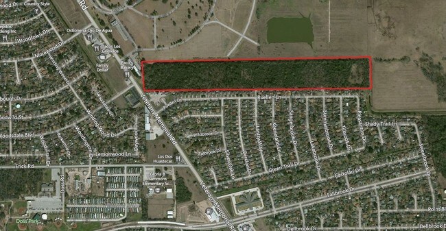
0 Veterans Memorial Dr, Houston, TX 77038

Property Detail
0 Veterans Memorial Dr
Houston-Pasadena-The Woodlands, TX
TR 2 ABST 1356 S S REYNOLDS
0471290000002
HARRIS
Commercialacreage
Texas
B and X Area of moderate flood hazard, usually the area between the limits of the 100-year and 500-year floods.
3.49 AC
2024
Greenspoint/N Belt West
2025
Houston
533702
NEARBY LISTINGS FOR SALE OR LEASE
-
-
-
-
-
-
No Photo
-
-
View all Houston listings for sale on LoopNet.com
DEMOGRAPHICS near 0 Veterans Memorial Dr
1 mile
3 mile
5 mile
2025 Total Population
10,997
125,037
336,893
2030 Population
11,650
132,324
357,020
Pop Growth 2025-2030
+ 5.94%
+ 5.83%
+ 5.97%
Average Age
36
35
35
2025 Total Households
2,953
37,898
105,681
HH Growth 2025-2030
+ 6.13%
+ 6.08%
+ 6.27%
Median Household Inc
$62,619
$50,578
$52,127
Avg Household Size
3.60
3.20
3.10
2025 Avg HH Vehicles
2.00
2.00
2.00
Median Home Value
$167,646
$191,456
$209,762
Median Year Built
1978
1984
1985
Nearby Places
Map Layers
Map Styles
 Street
 Aerial
Transit
 Traffic
 Biking
Places
Listings with unknown addresses are not visible on the map
- Restaurants
- Banks
- Shops
- Fitness
- Groceries
PUBLIC TRANSPORTATION
AIRPORT
George Bush Intcntl/Houston
Drive
Walk
Distance
George Bush Intcntl/Houston
18 min
12.4 mi
William P Hobby
Drive
Walk
Distance
William P Hobby
42 min
25.7 mi
Freight Ports
Port of Houston
Drive
Walk
Distance
Port of Houston
34 min
21.3 mi
SALE & LEASE HISTORY
LISTING DATE
SALE/LEASE

Sep 24, 2016
For Sale
Nearby Properties
Address
Land Use
TOTAL SIZE
Lot Size
Zoning
Address
Land Use
TOTAL SIZE
Lot Size
Zoning
858,420 SF
60.71 AC
Address
Land Use
TOTAL SIZE
Lot Size
Zoning
145.62 AC
Address
Land Use
TOTAL SIZE
Lot Size
Zoning
739,141 SF
54 AC
Address
Land Use
TOTAL SIZE
Lot Size
Zoning
413,178 SF
21.45 AC
Address
Land Use
TOTAL SIZE
Lot Size
Zoning
614,256 SF
31.25 AC
Address
Land Use
TOTAL SIZE
Lot Size
Zoning
608,784 SF
29.08 AC
Address
Land Use
TOTAL SIZE
Lot Size
Zoning
718,600 SF
42.09 AC
Address
Land Use
TOTAL SIZE
Lot Size
Zoning
504,000 SF
32.25 AC
Address
Land Use
TOTAL SIZE
Lot Size
Zoning
424,122 SF
21.06 AC
Address
Land Use
TOTAL SIZE
Lot Size
Zoning
356,900 SF
19.38 AC
Address
Land Use
TOTAL SIZE
Lot Size
Zoning
350,500 SF
17.71 AC
Address
Land Use
TOTAL SIZE
Lot Size
Zoning
125,512 SF
18.26 AC
Address
Land Use
TOTAL SIZE
Lot Size
Zoning
423,730 SF
5.91 AC
Address
Land Use
TOTAL SIZE
Lot Size
Zoning
284,476 SF
20 AC
Address
Land Use
TOTAL SIZE
Lot Size
Zoning
284,687 SF
19.66 AC
Address
Land Use
TOTAL SIZE
Lot Size
Zoning
200,123 SF
14.94 AC
Address
Land Use
TOTAL SIZE
Lot Size
Zoning
383,451 SF
15.98 AC
Address
Land Use
TOTAL SIZE
Lot Size
Zoning
240,240 SF
14.35 AC
Address
Land Use
TOTAL SIZE
Lot Size
Zoning
251,812 SF
12.22 AC
Address
Land Use
TOTAL SIZE
Lot Size
Zoning
244,864 SF
12.30 AC
Address
Land Use
TOTAL SIZE
Lot Size
Zoning
208,008 SF
8.32 AC
Address
Land Use
TOTAL SIZE
Lot Size
Zoning
244,760 SF
17.20 AC
Address
Land Use
TOTAL SIZE
Lot Size
Zoning
241,946 SF
14.02 AC
Address
Land Use
TOTAL SIZE
Lot Size
Zoning
379,255 SF
22.65 AC
Address
Land Use
TOTAL SIZE
Lot Size
Zoning
293,270 SF
8.29 AC
Address
Land Use
TOTAL SIZE
Lot Size
Zoning
202,362 SF
8.02 AC
Address
Land Use
TOTAL SIZE
Lot Size
Zoning
261,000 SF
13.89 AC
Address
Land Use
TOTAL SIZE
Lot Size
Zoning
319,231 SF
14.97 AC
Address
Land Use
TOTAL SIZE
Lot Size
Zoning
318,135 SF
14.11 AC
Address
Land Use
TOTAL SIZE
Lot Size
Zoning
250,660 SF
14.22 AC
The World's #1 Commercial Real Estate Marketplace
Connect with us
© 2026 CoStar Group
The information above has been obtained from sources believed reliable. While we do not doubt its accuracy we have not verified it and make no guarantee, warranty or representation about it. It is your responsibility to independently confirm its accuracy and completeness. Any projections, opinions, assumptions, or estimates used are for example only and do not represent the current or future performance of the property. The value of this transaction to you depends on tax and other factors which should be evaluated by your tax, financial, and legal advisors. You and your advisors should conduct a careful, independent investigation of the property to determine to your satisfaction the suitability of the property for your needs.