Property Record
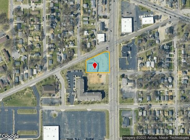
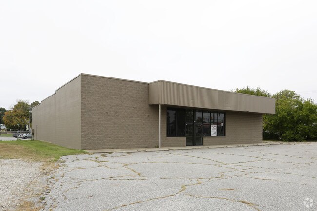
1033 N Bendix Dr, South Bend, IN 46628

NEARBY LISTINGS FOR SALE OR LEASE
Property Detail
1033 N Bendix Dr
South Bend-Mishawaka, IN-MI
Par Of Land Beg 60 W & 940.33 N Of Se Co
71-08-04-277-004.000-026
PAR OF LAND BEG 60 W & 940.33 N OF SE COR NE1/4 SEC 4-37-2E OUTLOT # 1
Servicestationmarket
St Joseph
X
Indiana
18141C0183D
1
2023
0.80 AC
2024
Greater South Bend
000100
South Bend/Mishawaka
7,200 SF
DEMOGRAPHICS near 1033 N Bendix Dr
1 Mile
3 Mile
5 Mile
2024 Total Population
10,066
61,783
134,861
2029 Population
10,179
62,355
135,397
Pop Growth 2024-2029
+ 1.12%
+ 0.93%
+ 0.40%
Average Age
35
35
37
2024 Total Households
3,729
22,544
50,862
HH Growth 2024-2029
+ 1.02%
+ 0.91%
+ 0.39%
Median Household Inc
$33,075
$41,610
$51,199
Avg Household Size
2.60
2.50
2.40
2024 Avg HH Vehicles
1.00
1.00
2.00
Median Home Value
$64,518
$86,133
$129,310
Median Year Built
1953
1954
1957
Nearby Places
Map Layers
Map Styles
 Street
 Aerial
- Restaurants
- Banks
- Shops
- Fitness
- Groceries
PUBLIC TRANSPORTATION
AIRPORT
South Bend International
DRIVE
WALK
Distance
South Bend International
4 min
2.4 mi
Freight Ports
Port of Baltimore
DRIVE
WALK
Distance
Port of Baltimore
1 min
536.2 mi
SALE & LEASE HISTORY
LISTING DATE
SALE/LEASE

Sep 25, 2016
For Lease
Apr 27, 2017
For Sale
Nearby Properties
Address
Land Use
TOTAL SIZE
Lot Size
Zoning
Address
Land Use
TOTAL SIZE
Lot Size
Zoning
685,709 SF
44 SF
Address
Land Use
TOTAL SIZE
Lot Size
Zoning
291,729 SF
0.79 AC
Address
Land Use
TOTAL SIZE
Lot Size
Zoning
538,338 SF
0.01 AC
Address
Land Use
TOTAL SIZE
Lot Size
Zoning
393,123 SF
2.91 AC
Address
Land Use
TOTAL SIZE
Lot Size
Zoning
158,616 SF
0.85 AC
Address
Land Use
TOTAL SIZE
Lot Size
Zoning
25,756 SF
337.40 AC
Address
Land Use
TOTAL SIZE
Lot Size
Zoning
356,520 SF
28.07 AC
Address
Land Use
TOTAL SIZE
Lot Size
Zoning
128,298 SF
0.84 AC
Address
Land Use
TOTAL SIZE
Lot Size
Zoning
194,931 SF
44 SF
Address
Land Use
TOTAL SIZE
Lot Size
Zoning
747,842 SF
30.05 AC
Address
Land Use
TOTAL SIZE
Lot Size
Zoning
142,065 SF
44 SF
Address
Land Use
TOTAL SIZE
Lot Size
Zoning
159,834 SF
44 SF
Address
Land Use
TOTAL SIZE
Lot Size
Zoning
161,548 SF
44 SF
Address
Land Use
TOTAL SIZE
Lot Size
Zoning
544,872 SF
70.95 AC
Address
Land Use
TOTAL SIZE
Lot Size
Zoning
178,111 SF
44 SF
Address
Land Use
TOTAL SIZE
Lot Size
Zoning
260,370 SF
Address
Land Use
TOTAL SIZE
Lot Size
Zoning
172,368 SF
2.22 AC
Address
Land Use
TOTAL SIZE
Lot Size
Zoning
55,995 SF
0.78 AC
Address
Land Use
TOTAL SIZE
Lot Size
Zoning
114,844 SF
4.17 AC
Address
Land Use
TOTAL SIZE
Lot Size
Zoning
633,136 SF
2.59 AC
Address
Land Use
TOTAL SIZE
Lot Size
Zoning
165,725 SF
0.01 AC
Address
Land Use
TOTAL SIZE
Lot Size
Zoning
100,368 SF
44 SF
Address
Land Use
TOTAL SIZE
Lot Size
Zoning
138,993 SF
0.38 AC
Address
Land Use
TOTAL SIZE
Lot Size
Zoning
201,264 SF
1.45 AC
Address
Land Use
TOTAL SIZE
Lot Size
Zoning
90,855 SF
3.07 AC
Address
Land Use
TOTAL SIZE
Lot Size
Zoning
178,316 SF
44 SF
Address
Land Use
TOTAL SIZE
Lot Size
Zoning
284,474 SF
7.61 AC
Address
Land Use
TOTAL SIZE
Lot Size
Zoning
89,802 SF
0.68 AC
Address
Land Use
TOTAL SIZE
Lot Size
Zoning
74,976 SF
44 SF
Address
Land Use
TOTAL SIZE
Lot Size
Zoning
94,801 SF
2.70 AC
The World's #1 Commercial Real Estate Marketplace
Connect with us
© 2025 CoStar Group
The information above has been obtained from sources believed reliable. While we do not doubt its accuracy we have not verified it and make no guarantee, warranty or representation about it. It is your responsibility to independently confirm its accuracy and completeness. Any projections, opinions, assumptions, or estimates used are for example only and do not represent the current or future performance of the property. The value of this transaction to you depends on tax and other factors which should be evaluated by your tax, financial, and legal advisors. You and your advisors should conduct a careful, independent investigation of the property to determine to your satisfaction the suitability of the property for your needs.