Property Record
1033 Riverview Dr, Walnutport, PA 18088
Current Lease Availabilities
NEARBY LISTINGS FOR SALE OR LEASE
Property Detail
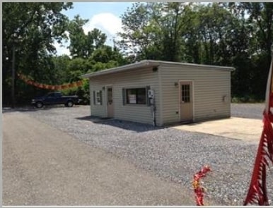
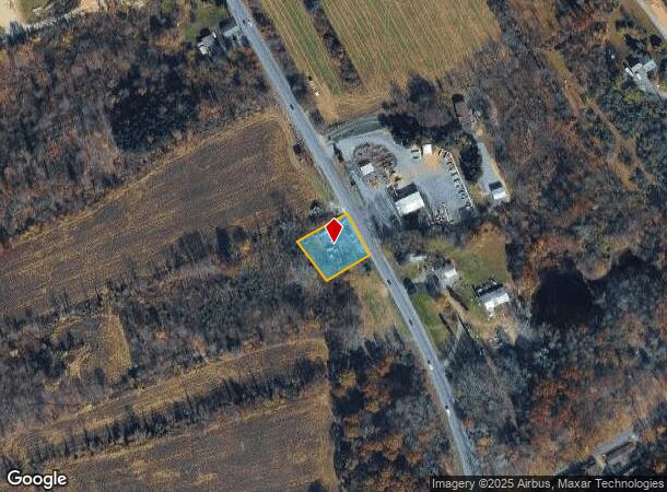
1033 Riverview Dr
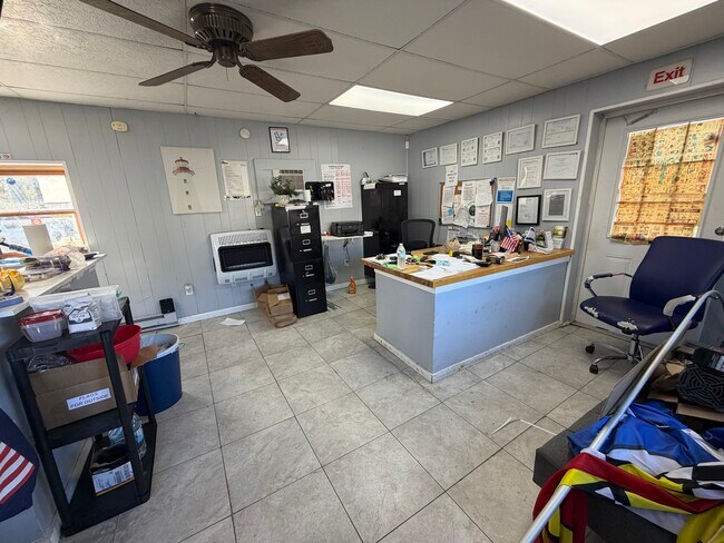
Storebuilding
Northampton
X
Pennsylvania
42095C0088E
0.40 AC
2025
Lehigh Valley
2025
Philadelphia
016002
Allentown-Bethlehem-Easton, PA-NJ
416 SF
J2-4-1A-0516
DEMOGRAPHICS near 1033 Riverview Dr
1 Mile
3 Mile
5 Mile
2024 Total Population
2,151
18,690
33,802
2029 Population
2,167
18,839
34,017
Pop Growth 2024-2029
+ 0.74%
+ 0.80%
+ 0.64%
Average Age
44
43
44
2024 Total Households
911
7,795
13,808
HH Growth 2024-2029
+ 0.77%
+ 0.83%
+ 0.65%
Median Household Inc
$53,718
$61,339
$69,313
Avg Household Size
2.30
2.40
2.40
2024 Avg HH Vehicles
2.00
2.00
2.00
Median Home Value
$193,961
$189,332
$223,194
Median Year Built
1965
1962
1970
Nearby Places
- Restaurants
- Banks
- Shops
- Fitness
- Groceries
PUBLIC TRANSPORTATION
AIRPORT
Lehigh Valley International
DRIVE
WALK
Distance
Lehigh Valley International
24 min
15.7 mi
Freight Ports
Port of Philadelphia
DRIVE
WALK
Distance
Port of Philadelphia
96 min
72.1 mi
Nearby Properties
Address
Land Use
TOTAL SIZE
Lot Size
Zoning
Address
Land Use
TOTAL SIZE
Lot Size
Zoning
101,962 SF
28.02 AC
SR
Address
Land Use
TOTAL SIZE
Lot Size
Zoning
112,243 SF
18 AC
SR
Address
Land Use
TOTAL SIZE
Lot Size
Zoning
61,636 SF
2.70 AC
TR
Address
Land Use
TOTAL SIZE
Lot Size
Zoning
784.80 AC
BM
Address
Land Use
TOTAL SIZE
Lot Size
Zoning
25,767 SF
0.39 AC
TC
Address
Land Use
TOTAL SIZE
Lot Size
Zoning
17,636 SF
2.51 AC
SR
Address
Land Use
TOTAL SIZE
Lot Size
Zoning
7,396 SF
175.58 AC
BM
Address
Land Use
TOTAL SIZE
Lot Size
Zoning
15,655 SF
11.32 AC
BM
Address
Land Use
TOTAL SIZE
Lot Size
Zoning
11,029 SF
4.79 AC
TR
Address
Land Use
TOTAL SIZE
Lot Size
Zoning
1.05 AC
Address
Land Use
TOTAL SIZE
Lot Size
Zoning
235,207 SF
11.35 AC
I
Address
Land Use
TOTAL SIZE
Lot Size
Zoning
5,534 SF
181.51 AC
BM
Address
Land Use
TOTAL SIZE
Lot Size
Zoning
12,192 SF
0.24 AC
TR
Address
Land Use
TOTAL SIZE
Lot Size
Zoning
118,072 SF
12.69 AC
R40
Address
Land Use
TOTAL SIZE
Lot Size
Zoning
15,589 SF
15.86 AC
GI
Address
Land Use
TOTAL SIZE
Lot Size
Zoning
20,261 SF
4.40 AC
C
Address
Land Use
TOTAL SIZE
Lot Size
Zoning
49.52 AC
R-40
Address
Land Use
TOTAL SIZE
Lot Size
Zoning
816 SF
0.35 AC
Address
Land Use
TOTAL SIZE
Lot Size
Zoning
3,751 SF
56.46 AC
I
Address
Land Use
TOTAL SIZE
Lot Size
Zoning
12,803 SF
0.93 AC
TR
Address
Land Use
TOTAL SIZE
Lot Size
Zoning
7,968 SF
0.40 AC
TR
Address
Land Use
TOTAL SIZE
Lot Size
Zoning
56,250 SF
5.36 AC
C
Address
Land Use
TOTAL SIZE
Lot Size
Zoning
44.92 AC
RA
Address
Land Use
TOTAL SIZE
Lot Size
Zoning
7,104 SF
3.18 AC
TR
Address
Land Use
TOTAL SIZE
Lot Size
Zoning
132.20 AC
BM
Address
Land Use
TOTAL SIZE
Lot Size
Zoning
1,344 SF
3.56 AC
Address
Land Use
TOTAL SIZE
Lot Size
Zoning
682.58 AC
RA
Address
Land Use
TOTAL SIZE
Lot Size
Zoning
5,460 SF
0.26 AC
TC
Address
Land Use
TOTAL SIZE
Lot Size
Zoning
4,984 SF
0.19 AC
TR
Address
Land Use
TOTAL SIZE
Lot Size
Zoning
53,708 SF
5.65 AC
C
The World's #1 Commercial Real Estate Marketplace
Connect with us
© 2025 CoStar Group
The information above has been obtained from sources believed reliable. While we do not doubt its accuracy we have not verified it and make no guarantee, warranty or representation about it. It is your responsibility to independently confirm its accuracy and completeness. Any projections, opinions, assumptions, or estimates used are for example only and do not represent the current or future performance of the property. The value of this transaction to you depends on tax and other factors which should be evaluated by your tax, financial, and legal advisors. You and your advisors should conduct a careful, independent investigation of the property to determine to your satisfaction the suitability of the property for your needs.