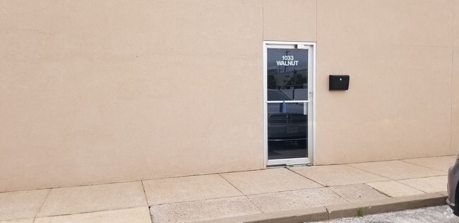
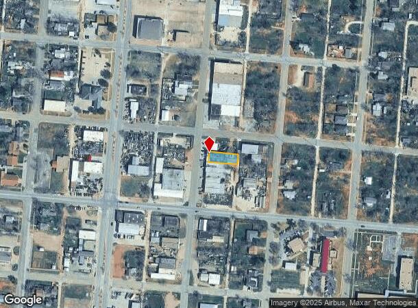
Property Record
1033 Walnut St, Abilene, TX 79601
NEARBY LISTINGS FOR SALE OR LEASE
Property Detail
1033 Walnut St
Abilene, TX
Ot Abilene
59576
LOT LT 8 200 2-5 GILMACHER ABL OT
Multipleuses
Taylor
X
Texas
48441C0228F
8
2024
0.16 AC
2025
Downtown Abilene
010800
Other Market Areas
4,750 SF
DEMOGRAPHICS near 1033 Walnut St
1 Mile
3 Mile
5 Mile
2024 Total Population
6,910
60,183
96,898
2029 Population
7,238
62,091
99,918
Pop Growth 2024-2029
+ 4.75%
+ 3.17%
+ 3.12%
Average Age
36
36
36
2024 Total Households
2,515
22,521
37,521
HH Growth 2024-2029
+ 5.21%
+ 3.38%
+ 3.29%
Median Household Inc
$37,773
$44,031
$48,784
Avg Household Size
2.40
2.40
2.40
2024 Avg HH Vehicles
2.00
2.00
2.00
Median Home Value
$65,169
$119,462
$133,316
Median Year Built
1952
1958
1967
Nearby Places
Map Layers
Map Styles
 Street
 Aerial
- Restaurants
- Banks
- Shops
- Fitness
- Groceries
PUBLIC TRANSPORTATION
AIRPORT
Abilene Regional
DRIVE
WALK
Distance
Abilene Regional
12 min
6.1 mi
Freight Ports
Calhoun Port
DRIVE
WALK
Distance
Calhoun Port
439 min
375.7 mi
SALE & LEASE HISTORY
LISTING DATE
SALE/LEASE

Oct 26, 2020
For Sale
Nov 01, 2019
For Lease
May 10, 2019
For Lease
Nearby Properties
Address
Land Use
TOTAL SIZE
Lot Size
Zoning
Address
Land Use
TOTAL SIZE
Lot Size
Zoning
959,214 SF
94.96 AC
Address
Land Use
TOTAL SIZE
Lot Size
Zoning
24.36 AC
Address
Land Use
TOTAL SIZE
Lot Size
Zoning
812,955 SF
99.27 AC
Address
Land Use
TOTAL SIZE
Lot Size
Zoning
169,821 SF
3.59 AC
Address
Land Use
TOTAL SIZE
Lot Size
Zoning
600,001 SF
39.40 AC
Address
Land Use
TOTAL SIZE
Lot Size
Zoning
411,104 SF
91.21 AC
Address
Land Use
TOTAL SIZE
Lot Size
Zoning
325,355 SF
9.83 AC
Address
Land Use
TOTAL SIZE
Lot Size
Zoning
141,777 SF
36.78 AC
Address
Land Use
TOTAL SIZE
Lot Size
Zoning
115,568 SF
23.57 AC
Address
Land Use
TOTAL SIZE
Lot Size
Zoning
212,450 SF
9.43 AC
Address
Land Use
TOTAL SIZE
Lot Size
Zoning
108,121 SF
15 AC
Address
Land Use
TOTAL SIZE
Lot Size
Zoning
95,893 SF
15.89 AC
Address
Land Use
TOTAL SIZE
Lot Size
Zoning
728,862 SF
102.37 AC
Address
Land Use
TOTAL SIZE
Lot Size
Zoning
620,165 SF
107.40 AC
Address
Land Use
TOTAL SIZE
Lot Size
Zoning
144,349 SF
11.07 AC
Address
Land Use
TOTAL SIZE
Lot Size
Zoning
166,224 SF
8.79 AC
Address
Land Use
TOTAL SIZE
Lot Size
Zoning
229,988 SF
9.22 AC
Address
Land Use
TOTAL SIZE
Lot Size
Zoning
88,656 SF
4.14 AC
Address
Land Use
TOTAL SIZE
Lot Size
Zoning
342,750 SF
34.54 AC
Address
Land Use
TOTAL SIZE
Lot Size
Zoning
71,515 SF
9.94 AC
Address
Land Use
TOTAL SIZE
Lot Size
Zoning
2.63 AC
Address
Land Use
TOTAL SIZE
Lot Size
Zoning
84,335 SF
4.68 AC
Address
Land Use
TOTAL SIZE
Lot Size
Zoning
52,028 SF
3.62 AC
Address
Land Use
TOTAL SIZE
Lot Size
Zoning
67,593 SF
49.82 AC
Address
Land Use
TOTAL SIZE
Lot Size
Zoning
209,580 SF
20.94 AC
Address
Land Use
TOTAL SIZE
Lot Size
Zoning
62,823 SF
9.39 AC
Address
Land Use
TOTAL SIZE
Lot Size
Zoning
130,048 SF
8.22 AC
Address
Land Use
TOTAL SIZE
Lot Size
Zoning
101,812 SF
6.28 AC
Address
Land Use
TOTAL SIZE
Lot Size
Zoning
60,944 SF
2.86 AC
Address
Land Use
TOTAL SIZE
Lot Size
Zoning
2.63 AC
The World's #1 Commercial Real Estate Marketplace
Connect with us
© 2025 CoStar Group
The information above has been obtained from sources believed reliable. While we do not doubt its accuracy we have not verified it and make no guarantee, warranty or representation about it. It is your responsibility to independently confirm its accuracy and completeness. Any projections, opinions, assumptions, or estimates used are for example only and do not represent the current or future performance of the property. The value of this transaction to you depends on tax and other factors which should be evaluated by your tax, financial, and legal advisors. You and your advisors should conduct a careful, independent investigation of the property to determine to your satisfaction the suitability of the property for your needs.