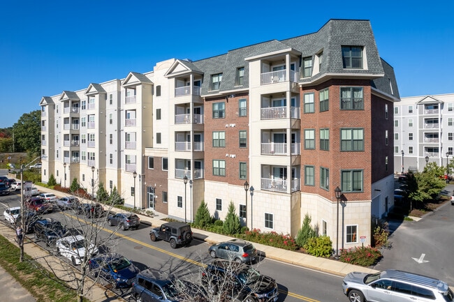
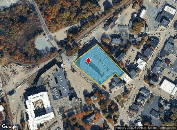
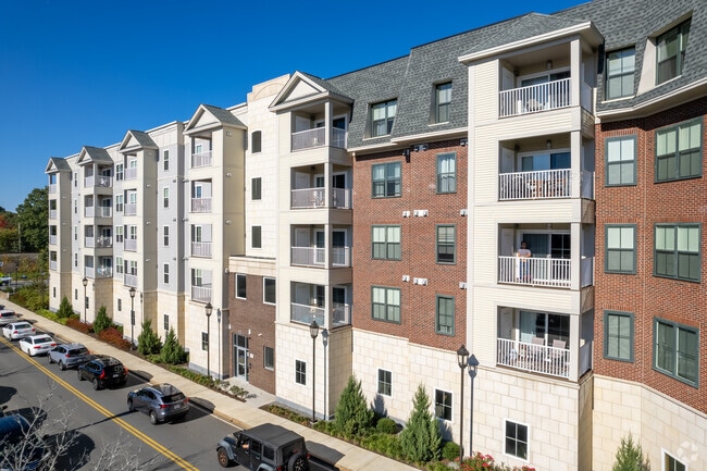
Property Record
1034 East St, Walpole, MA 02081
Current Lease Availabilities
NEARBY LISTINGS FOR SALE OR LEASE
Property Detail
1034 East St
Apartment
Norfolk
AE
Massachusetts
25021C0169F
2.39 AC
2025
Outer Route 1 South
2025
Boston
411302
Boston-Cambridge-Newton, MA-NH
211,362 SF
WALP M:00033 B:00023 L:00000
DEMOGRAPHICS near 1034 East St
1 Mile
3 Mile
5 Mile
2024 Total Population
7,991
34,384
98,320
2029 Population
8,167
34,395
97,819
Pop Growth 2024-2029
+ 2.20%
+ 0.03%
(0.51%)
Average Age
43
41
41
2024 Total Households
3,251
12,498
36,396
HH Growth 2024-2029
+ 2.40%
+ 0.10%
(0.57%)
Median Household Inc
$116,504
$139,218
$135,126
Avg Household Size
2.40
2.70
2.60
2024 Avg HH Vehicles
2.00
2.00
2.00
Median Home Value
$561,910
$673,476
$676,355
Median Year Built
1978
1975
1968
Nearby Places
Map Layers
Map Styles
 Street
 Aerial
- Restaurants
- Banks
- Shops
- Fitness
- Groceries
PUBLIC TRANSPORTATION
COMMUTER RAIL
Walpole (Foxboro Line (Special Events Only) - Massachusetts Bay Transportation Authority Commuter Rail (Purple Line), Franklin Line - Massachusetts Bay Transportation Authority Commuter Rail (Purple Line))
DRIVE
WALK
Distance
Walpole (Foxboro Line (Special Events Only) - Massachusetts Bay Transportation Authority Commuter Rail (Purple Line), Franklin Line - Massachusetts Bay Transportation Authority Commuter Rail (Purple Line))
1 min
6 min
0.3 mi
Plimptonville (Franklin Line - Massachusetts Bay Transportation Authority Commuter Rail (Purple Line))
DRIVE
WALK
Distance
Plimptonville (Franklin Line - Massachusetts Bay Transportation Authority Commuter Rail (Purple Line))
4 min
1.6 mi
AIRPORT
General Edward Lawrence Logan International
DRIVE
WALK
Distance
General Edward Lawrence Logan International
37 min
29.3 mi
Freight Ports
Port of Boston
DRIVE
WALK
Distance
Port of Boston
1 min
18.1 mi
Nearby Properties
Address
Land Use
TOTAL SIZE
Lot Size
Zoning
Address
Land Use
TOTAL SIZE
Lot Size
Zoning
544,990 SF
63.29 AC
Address
Land Use
TOTAL SIZE
Lot Size
Zoning
198,498 SF
14 AC
Address
Land Use
TOTAL SIZE
Lot Size
Zoning
97.60 AC
Address
Land Use
TOTAL SIZE
Lot Size
Zoning
245,693 SF
2.57 AC
Address
Land Use
TOTAL SIZE
Lot Size
Zoning
2,385 SF
21.39 AC
Address
Land Use
TOTAL SIZE
Lot Size
Zoning
30.94 AC
Address
Land Use
TOTAL SIZE
Lot Size
Zoning
28,561 SF
26.30 AC
Address
Land Use
TOTAL SIZE
Lot Size
Zoning
81,009 SF
22.16 AC
Address
Land Use
TOTAL SIZE
Lot Size
Zoning
14.33 AC
Address
Land Use
TOTAL SIZE
Lot Size
Zoning
211,362 SF
2.39 AC
Address
Land Use
TOTAL SIZE
Lot Size
Zoning
89,960 SF
52.40 AC
Address
Land Use
TOTAL SIZE
Lot Size
Zoning
79,901 SF
11.46 AC
Address
Land Use
TOTAL SIZE
Lot Size
Zoning
11.98 AC
Address
Land Use
TOTAL SIZE
Lot Size
Zoning
127,556 SF
14.88 AC
Address
Land Use
TOTAL SIZE
Lot Size
Zoning
117.30 AC
Address
Land Use
TOTAL SIZE
Lot Size
Zoning
48,693 SF
9.02 AC
Address
Land Use
TOTAL SIZE
Lot Size
Zoning
52,214 SF
20 AC
Address
Land Use
TOTAL SIZE
Lot Size
Zoning
93,218 SF
9.68 AC
LI
Address
Land Use
TOTAL SIZE
Lot Size
Zoning
59,390 SF
5.69 AC
Address
Land Use
TOTAL SIZE
Lot Size
Zoning
100,012 SF
7.11 AC
Address
Land Use
TOTAL SIZE
Lot Size
Zoning
64,887 SF
21.10 AC
Address
Land Use
TOTAL SIZE
Lot Size
Zoning
54,948 SF
11.43 AC
Address
Land Use
TOTAL SIZE
Lot Size
Zoning
56,414 SF
7.63 AC
Address
Land Use
TOTAL SIZE
Lot Size
Zoning
102,024 SF
9.97 AC
LI
Address
Land Use
TOTAL SIZE
Lot Size
Zoning
147,984 SF
20.57 AC
Address
Land Use
TOTAL SIZE
Lot Size
Zoning
94,623 SF
8.17 AC
Address
Land Use
TOTAL SIZE
Lot Size
Zoning
101,171 SF
11.12 AC
LI
Address
Land Use
TOTAL SIZE
Lot Size
Zoning
124,519 SF
14.22 AC
LI
Address
Land Use
TOTAL SIZE
Lot Size
Zoning
73,607 SF
11.70 AC
Address
Land Use
TOTAL SIZE
Lot Size
Zoning
91,982 SF
5.21 AC
The World's #1 Commercial Real Estate Marketplace
Connect with us
© 2026 CoStar Group
The information above has been obtained from sources believed reliable. While we do not doubt its accuracy we have not verified it and make no guarantee, warranty or representation about it. It is your responsibility to independently confirm its accuracy and completeness. Any projections, opinions, assumptions, or estimates used are for example only and do not represent the current or future performance of the property. The value of this transaction to you depends on tax and other factors which should be evaluated by your tax, financial, and legal advisors. You and your advisors should conduct a careful, independent investigation of the property to determine to your satisfaction the suitability of the property for your needs.