Property Record
10342 Old Redwood Hwy, Windsor, CA 95492
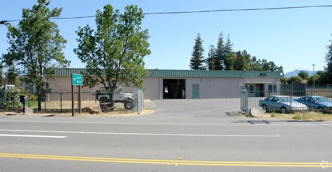
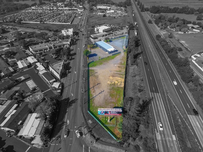

This Property Is For Sale
NEARBY LISTINGS FOR SALE OR LEASE
Property Detail
10342 Old Redwood Hwy
Santa Rosa, CA
As Said Lot Is Shown On Parcel Map No. 6
161-020-008
91 FM 065-100-78 # CHG PER MD
Warehouse
Sonoma
X
California
06097C0554E
2
2024
0.90 AC
2025
Healdsburg/Cloverdale
153904
North Bay/Santa Rosa
4,903 SF
DEMOGRAPHICS near 10342 Old Redwood Hwy
1 Mile
3 Mile
5 Mile
2024 Total Population
7,193
26,186
42,851
2029 Population
7,095
25,730
42,269
Pop Growth 2024-2029
(1.36%)
(1.74%)
(1.36%)
Average Age
41
42
43
2024 Total Households
2,303
9,062
15,844
HH Growth 2024-2029
(1.43%)
(1.84%)
(1.39%)
Median Household Inc
$137,617
$128,594
$119,059
Avg Household Size
3.00
2.80
2.60
2024 Avg HH Vehicles
3.00
2.00
2.00
Median Home Value
$752,912
$746,221
$768,695
Median Year Built
1989
1991
1986
Nearby Places
Map Layers
Map Styles
 Street
 Aerial
- Restaurants
- Banks
- Shops
- Fitness
- Groceries
PUBLIC TRANSPORTATION
COMMUTER RAIL
DRIVE
WALK
Distance
9 min
5.1 mi
DRIVE
WALK
Distance
14 min
9.8 mi
AIRPORT
Charles M Schulz - Sonoma County
DRIVE
WALK
Distance
Charles M Schulz - Sonoma County
10 min
6.0 mi
Freight Ports
Port of Richmond
DRIVE
WALK
Distance
Port of Richmond
75 min
58.9 mi
Nearby Properties
Address
Land Use
TOTAL SIZE
Lot Size
Zoning
Address
Land Use
TOTAL SIZE
Lot Size
Zoning
14.56 AC
Address
Land Use
TOTAL SIZE
Lot Size
Zoning
341,349 SF
63.97 AC
Address
Land Use
TOTAL SIZE
Lot Size
Zoning
249,088 SF
10.75 AC
Address
Land Use
TOTAL SIZE
Lot Size
Zoning
6,770 SF
0.18 AC
LIA60
Address
Land Use
TOTAL SIZE
Lot Size
Zoning
18.24 AC
Address
Land Use
TOTAL SIZE
Lot Size
Zoning
282,600 SF
6.89 AC
Address
Land Use
TOTAL SIZE
Lot Size
Zoning
36,242 SF
13.48 AC
LIA40
Address
Land Use
TOTAL SIZE
Lot Size
Zoning
70,511 SF
1.52 AC
Address
Land Use
TOTAL SIZE
Lot Size
Zoning
98,033 SF
1.39 AC
Address
Land Use
TOTAL SIZE
Lot Size
Zoning
35,648 SF
2.26 AC
M1
Address
Land Use
TOTAL SIZE
Lot Size
Zoning
107,188 SF
7.59 AC
PC
Address
Land Use
TOTAL SIZE
Lot Size
Zoning
0.18 AC
Address
Land Use
TOTAL SIZE
Lot Size
Zoning
38,416 SF
73.01 AC
LIA20
Address
Land Use
TOTAL SIZE
Lot Size
Zoning
5.22 AC
Address
Land Use
TOTAL SIZE
Lot Size
Zoning
34,857 SF
150.54 AC
Address
Land Use
TOTAL SIZE
Lot Size
Zoning
4.43 AC
Address
Land Use
TOTAL SIZE
Lot Size
Zoning
23,615 SF
0.09 AC
LIA20
Address
Land Use
TOTAL SIZE
Lot Size
Zoning
8,491 SF
38.59 AC
CITYWI
Address
Land Use
TOTAL SIZE
Lot Size
Zoning
74,740 SF
3.33 AC
Address
Land Use
TOTAL SIZE
Lot Size
Zoning
17,322 SF
410.90 AC
RRDW100
Address
Land Use
TOTAL SIZE
Lot Size
Zoning
36,423 SF
20.71 AC
Address
Land Use
TOTAL SIZE
Lot Size
Zoning
7,791 SF
23.38 AC
Address
Land Use
TOTAL SIZE
Lot Size
Zoning
52,726 SF
4.86 AC
PC
Address
Land Use
TOTAL SIZE
Lot Size
Zoning
93,692 SF
5.30 AC
Address
Land Use
TOTAL SIZE
Lot Size
Zoning
102,842 SF
13.35 AC
Address
Land Use
TOTAL SIZE
Lot Size
Zoning
4.99 AC
Address
Land Use
TOTAL SIZE
Lot Size
Zoning
37,948 SF
80 AC
Address
Land Use
TOTAL SIZE
Lot Size
Zoning
9,726 SF
20.21 AC
Address
Land Use
TOTAL SIZE
Lot Size
Zoning
42,500 SF
2.97 AC
Address
Land Use
TOTAL SIZE
Lot Size
Zoning
12,445 SF
0.17 AC
The World's #1 Commercial Real Estate Marketplace
Connect with us
© 2025 CoStar Group
The information above has been obtained from sources believed reliable. While we do not doubt its accuracy we have not verified it and make no guarantee, warranty or representation about it. It is your responsibility to independently confirm its accuracy and completeness. Any projections, opinions, assumptions, or estimates used are for example only and do not represent the current or future performance of the property. The value of this transaction to you depends on tax and other factors which should be evaluated by your tax, financial, and legal advisors. You and your advisors should conduct a careful, independent investigation of the property to determine to your satisfaction the suitability of the property for your needs.