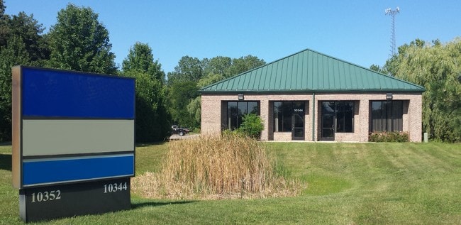
Property Record
10344 Gratiot Ave, Columbus, MI 48063

NEARBY LISTINGS FOR SALE OR LEASE
Property Detail
10344 Gratiot Ave
16-031-3014-000
N 122' OF S 851' OF SW 1/4 OF SE 1/4 LYING NW OF GRATIOT RD. SEC 31 T5N R15E 2.26 A
Gymhealthspa
St. Clair
X
Michigan
26147C0425D
2.26 AC
2024
St Clair & Lapeer Counties
2025
Detroit
651600
Detroit-Warren-Dearborn, MI
8,950 SF
DEMOGRAPHICS near 10344 Gratiot Ave
1 Mile
3 Mile
5 Mile
2024 Total Population
276
8,994
13,832
2029 Population
273
8,889
13,686
Pop Growth 2024-2029
(1.09%)
(1.17%)
(1.06%)
Average Age
43
43
42
2024 Total Households
112
3,606
5,409
HH Growth 2024-2029
(0.89%)
(1.25%)
(1.15%)
Median Household Inc
$72,856
$72,672
$75,033
Avg Household Size
2.40
2.50
2.50
2024 Avg HH Vehicles
2.00
2.00
2.00
Median Home Value
$255,555
$242,910
$247,089
Median Year Built
1979
1981
1981
Nearby Places
Map Layers
Map Styles
 Street
 Aerial
- Restaurants
- Banks
- Shops
- Fitness
- Groceries
PUBLIC TRANSPORTATION
AIRPORT
Detroit City
DRIVE
WALK
Distance
Detroit City
48 min
39.5 mi
SALE & LEASE HISTORY
LISTING DATE
SALE/LEASE

Sep 25, 2016
For Lease
Sep 23, 2016
For Sale
Oct 25, 2019
For Sale
Nov 01, 2023
For Sale
Feb 13, 2020
For Lease
Aug 10, 2017
For Sale
Apr 13, 2017
For Sale
Nearby Properties
Address
Land Use
TOTAL SIZE
Lot Size
Zoning
Address
Land Use
TOTAL SIZE
Lot Size
Zoning
102,913 SF
B-3
Address
Land Use
TOTAL SIZE
Lot Size
Zoning
86,155 SF
17.46 AC
RM-1
Address
Land Use
TOTAL SIZE
Lot Size
Zoning
83,316 SF
11.93 AC
B-3
Address
Land Use
TOTAL SIZE
Lot Size
Zoning
218,105 SF
12.09 AC
I-1
Address
Land Use
TOTAL SIZE
Lot Size
Zoning
21,520 SF
5.54 AC
B-3
Address
Land Use
TOTAL SIZE
Lot Size
Zoning
20,070 SF
5 AC
CG
Address
Land Use
TOTAL SIZE
Lot Size
Zoning
50,854 SF
3.79 AC
RM-1
Address
Land Use
TOTAL SIZE
Lot Size
Zoning
64,565 SF
16.60 AC
IND20KSF
Address
Land Use
TOTAL SIZE
Lot Size
Zoning
37,807 SF
4.41 AC
B-3
Address
Land Use
TOTAL SIZE
Lot Size
Zoning
31,170 SF
8.16 AC
B-3
Address
Land Use
TOTAL SIZE
Lot Size
Zoning
99,504 SF
10.40 AC
B-3
Address
Land Use
TOTAL SIZE
Lot Size
Zoning
1,104 SF
79.25 AC
CG
Address
Land Use
TOTAL SIZE
Lot Size
Zoning
21,200 SF
22.25 AC
CG
Address
Land Use
TOTAL SIZE
Lot Size
Zoning
27,754 SF
2.58 AC
RM-1
Address
Land Use
TOTAL SIZE
Lot Size
Zoning
26,479 SF
2.95 AC
RM-1
Address
Land Use
TOTAL SIZE
Lot Size
Zoning
25.07 AC
I-1
Address
Land Use
TOTAL SIZE
Lot Size
Zoning
91,910 SF
11.64 AC
B-3
Address
Land Use
TOTAL SIZE
Lot Size
Zoning
17,995 SF
2.66 AC
O
Address
Land Use
TOTAL SIZE
Lot Size
Zoning
11,040 SF
152.52 AC
AG
Address
Land Use
TOTAL SIZE
Lot Size
Zoning
4,416 SF
52.54 AC
RLD
Address
Land Use
TOTAL SIZE
Lot Size
Zoning
27,616 SF
1.86 AC
RM-1
Address
Land Use
TOTAL SIZE
Lot Size
Zoning
30,000 SF
10 AC
INDUSTR
Address
Land Use
TOTAL SIZE
Lot Size
Zoning
21,420 SF
5.11 AC
RM-1
Address
Land Use
TOTAL SIZE
Lot Size
Zoning
13,367 SF
1.22 AC
B-3
Address
Land Use
TOTAL SIZE
Lot Size
Zoning
9,525 SF
6.56 AC
O
Address
Land Use
TOTAL SIZE
Lot Size
Zoning
47,074 SF
6.47 AC
I-1
Address
Land Use
TOTAL SIZE
Lot Size
Zoning
1.57 AC
Address
Land Use
TOTAL SIZE
Lot Size
Zoning
3,146 SF
16.48 AC
R-4
Address
Land Use
TOTAL SIZE
Lot Size
Zoning
19,360 SF
1.25 AC
RM-1
Address
Land Use
TOTAL SIZE
Lot Size
Zoning
8,838 SF
1.16 AC
RM-1
The World's #1 Commercial Real Estate Marketplace
Connect with us
© 2025 CoStar Group
The information above has been obtained from sources believed reliable. While we do not doubt its accuracy we have not verified it and make no guarantee, warranty or representation about it. It is your responsibility to independently confirm its accuracy and completeness. Any projections, opinions, assumptions, or estimates used are for example only and do not represent the current or future performance of the property. The value of this transaction to you depends on tax and other factors which should be evaluated by your tax, financial, and legal advisors. You and your advisors should conduct a careful, independent investigation of the property to determine to your satisfaction the suitability of the property for your needs.