Property Record
10346 Sw B & R Ranch Rd, Arcadia, FL 34266
NEARBY LISTINGS FOR SALE OR LEASE
-
-
View all Arcadia listings for sale on LoopNet.com
Property Detail
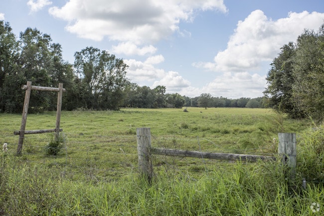
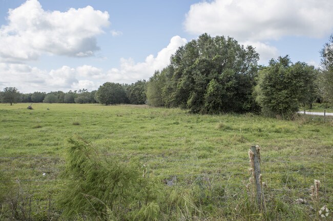
10346 Sw B & R Ranch Rd
Arcadia, FL
N1/2 OF N3/4 OF N1/2 BEING LOTS 1 THRU 8 & PART OF LOTS 9 THRU 16 LESS & EXCEPT COMM NE COR SEC 4 TH S 01D14M 06S W ALG E LI SEC 4 895.67 FT TO A POINT ON N R/W 100 FT ESMT TH N 88D38M28S W ALG SAID R/W 3612.31 FT TH N 07D11M56S W 365.31 FT TH N 17D3
32-38-23-0000-0020-0000
DeSoto
Pasture
Florida
A
1-16
12027C0257D
580.05 AC
2024
Florida Central South Area
2024
Other Market Areas
010405
DEMOGRAPHICS near 10346 Sw B & R Ranch Rd
1 Mile
3 Mile
5 Mile
2024 Total Population
107
517
3,309
2029 Population
120
564
3,590
Pop Growth 2024-2029
+ 12.15%
+ 9.09%
+ 8.49%
Average Age
50
46
51
2024 Total Households
45
202
1,400
HH Growth 2024-2029
+ 11.11%
+ 9.90%
+ 9.14%
Median Household Inc
$64,500
$48,105
$48,925
Avg Household Size
2.40
2.40
2.20
2024 Avg HH Vehicles
2.00
2.00
2.00
Median Home Value
$194,999
$187,096
$146,561
Median Year Built
1989
1988
1989
Nearby Places
Map Layers
Map Styles
 Street
 Aerial
- Restaurants
- Banks
- Shops
- Fitness
- Groceries
PUBLIC TRANSPORTATION
AIRPORT
Punta Gorda
DRIVE
WALK
Distance
Punta Gorda
33 min
18.6 mi
Freight Ports
Port Manatee
DRIVE
WALK
Distance
Port Manatee
93 min
73.1 mi
Nearby Properties
Address
Land Use
TOTAL SIZE
Lot Size
Zoning
Address
Land Use
TOTAL SIZE
Lot Size
Zoning
653.75 AC
A-10
Address
Land Use
TOTAL SIZE
Lot Size
Zoning
173.33 AC
P/I
Address
Land Use
TOTAL SIZE
Lot Size
Zoning
594.36 AC
A-10
Address
Land Use
TOTAL SIZE
Lot Size
Zoning
153.66 AC
P/I
Address
Land Use
TOTAL SIZE
Lot Size
Zoning
1,836 SF
17.80 AC
P/I
Address
Land Use
TOTAL SIZE
Lot Size
Zoning
664.09 AC
EC
Address
Land Use
TOTAL SIZE
Lot Size
Zoning
657.01 AC
EC
Address
Land Use
TOTAL SIZE
Lot Size
Zoning
651.43 AC
A-10
Address
Land Use
TOTAL SIZE
Lot Size
Zoning
649.60 AC
A-10
Address
Land Use
TOTAL SIZE
Lot Size
Zoning
603.33 AC
A-10
Address
Land Use
TOTAL SIZE
Lot Size
Zoning
520.65 AC
A-10
Address
Land Use
TOTAL SIZE
Lot Size
Zoning
31.61 AC
RVC
Address
Land Use
TOTAL SIZE
Lot Size
Zoning
435.02 AC
A-10
Address
Land Use
TOTAL SIZE
Lot Size
Zoning
65.31 AC
P/I
Address
Land Use
TOTAL SIZE
Lot Size
Zoning
332.95 AC
A-10
Address
Land Use
TOTAL SIZE
Lot Size
Zoning
6,845 SF
531.70 AC
A-10
Address
Land Use
TOTAL SIZE
Lot Size
Zoning
2,689 SF
398.23 AC
A-10
Address
Land Use
TOTAL SIZE
Lot Size
Zoning
227.49 AC
A-10
Address
Land Use
TOTAL SIZE
Lot Size
Zoning
5,937 SF
586.38 AC
A-10
Address
Land Use
TOTAL SIZE
Lot Size
Zoning
216.36 AC
A-10
Address
Land Use
TOTAL SIZE
Lot Size
Zoning
351 AC
A-10
Address
Land Use
TOTAL SIZE
Lot Size
Zoning
195.25 AC
A-10
Address
Land Use
TOTAL SIZE
Lot Size
Zoning
1,537 SF
10.97 AC
RVC
Address
Land Use
TOTAL SIZE
Lot Size
Zoning
4,828 SF
12.51 AC
A-10
Address
Land Use
TOTAL SIZE
Lot Size
Zoning
170.24 AC
A-10
Address
Land Use
TOTAL SIZE
Lot Size
Zoning
88.49 AC
A-10
Address
Land Use
TOTAL SIZE
Lot Size
Zoning
110.23 AC
A-10
Address
Land Use
TOTAL SIZE
Lot Size
Zoning
14,149 SF
12.20 AC
A-10
Address
Land Use
TOTAL SIZE
Lot Size
Zoning
169 AC
A-10
Address
Land Use
TOTAL SIZE
Lot Size
Zoning
1,866 SF
7.72 AC
A-5
The World's #1 Commercial Real Estate Marketplace
Connect with us
© 2025 CoStar Group
The information above has been obtained from sources believed reliable. While we do not doubt its accuracy we have not verified it and make no guarantee, warranty or representation about it. It is your responsibility to independently confirm its accuracy and completeness. Any projections, opinions, assumptions, or estimates used are for example only and do not represent the current or future performance of the property. The value of this transaction to you depends on tax and other factors which should be evaluated by your tax, financial, and legal advisors. You and your advisors should conduct a careful, independent investigation of the property to determine to your satisfaction the suitability of the property for your needs.