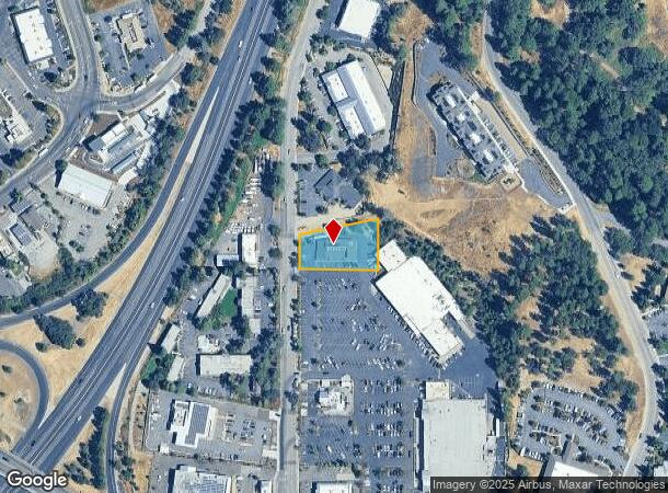
Property Record
1035 Sutton Way, Grass Valley, CA 95945
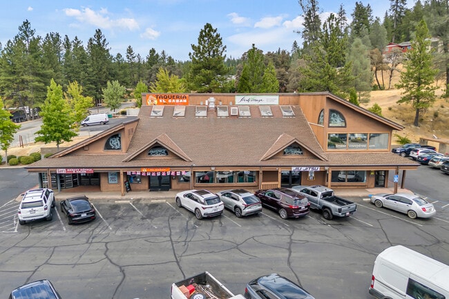


This Property Is For Sale
NEARBY LISTINGS FOR SALE OR LEASE
Property Detail
1035 Sutton Way
035-400-050-000
PCL C PM 14/39
Storebuilding
Nevada
X
California
06057C0631E
c
2024
0.60 AC
2025
California North Rural Area
000601
Other Market Areas
7,431 SF
Truckee-Grass Valley, CA
DEMOGRAPHICS near 1035 Sutton Way
1 Mile
3 Mile
5 Mile
2024 Total Population
4,818
25,004
35,814
2029 Population
4,842
24,794
35,415
Pop Growth 2024-2029
+ 0.50%
(0.84%)
(1.11%)
Average Age
49
48
48
2024 Total Households
1,973
10,922
15,467
HH Growth 2024-2029
+ 0.66%
(0.89%)
(1.14%)
Median Household Inc
$34,275
$58,022
$63,256
Avg Household Size
2.10
2.10
2.20
2024 Avg HH Vehicles
1.00
2.00
2.00
Median Home Value
$469,696
$485,048
$495,407
Median Year Built
1982
1975
1977
Nearby Places
- Restaurants
- Banks
- Shops
- Fitness
- Groceries
Nearby Properties
Address
Land Use
TOTAL SIZE
Lot Size
Zoning
Address
Land Use
TOTAL SIZE
Lot Size
Zoning
Address
Land Use
TOTAL SIZE
Lot Size
Zoning
185,765 SF
26.56 AC
Address
Land Use
TOTAL SIZE
Lot Size
Zoning
145,522 SF
6.39 AC
Address
Land Use
TOTAL SIZE
Lot Size
Zoning
74,019 SF
4.20 AC
Address
Land Use
TOTAL SIZE
Lot Size
Zoning
45,263 SF
2.61 AC
Address
Land Use
TOTAL SIZE
Lot Size
Zoning
56,318 SF
2.49 AC
Address
Land Use
TOTAL SIZE
Lot Size
Zoning
45,427 SF
4.06 AC
Address
Land Use
TOTAL SIZE
Lot Size
Zoning
11.47 AC
C2-SP
Address
Land Use
TOTAL SIZE
Lot Size
Zoning
26,556 SF
0.49 AC
Address
Land Use
TOTAL SIZE
Lot Size
Zoning
28,125 SF
7.12 AC
Address
Land Use
TOTAL SIZE
Lot Size
Zoning
14,550 SF
1.95 AC
Address
Land Use
TOTAL SIZE
Lot Size
Zoning
48,000 SF
3.52 AC
Address
Land Use
TOTAL SIZE
Lot Size
Zoning
Address
Land Use
TOTAL SIZE
Lot Size
Zoning
7.84 AC
Address
Land Use
TOTAL SIZE
Lot Size
Zoning
21,505 SF
4.13 AC
Address
Land Use
TOTAL SIZE
Lot Size
Zoning
14,504 SF
2.21 AC
Address
Land Use
TOTAL SIZE
Lot Size
Zoning
19,072 SF
2.93 AC
Address
Land Use
TOTAL SIZE
Lot Size
Zoning
87,696 SF
4.80 AC
Address
Land Use
TOTAL SIZE
Lot Size
Zoning
40,969 SF
3.48 AC
Address
Land Use
TOTAL SIZE
Lot Size
Zoning
65,468 SF
3.84 AC
Address
Land Use
TOTAL SIZE
Lot Size
Zoning
47,976 SF
4.52 AC
Address
Land Use
TOTAL SIZE
Lot Size
Zoning
41,130 SF
2.29 AC
Address
Land Use
TOTAL SIZE
Lot Size
Zoning
22,155 SF
2.77 AC
Address
Land Use
TOTAL SIZE
Lot Size
Zoning
33,642 SF
0.95 AC
Address
Land Use
TOTAL SIZE
Lot Size
Zoning
Address
Land Use
TOTAL SIZE
Lot Size
Zoning
26,218 SF
3.37 AC
Address
Land Use
TOTAL SIZE
Lot Size
Zoning
17,210 SF
2.29 AC
Address
Land Use
TOTAL SIZE
Lot Size
Zoning
33,450 SF
2.13 AC
M1-SP
Address
Land Use
TOTAL SIZE
Lot Size
Zoning
49,672 SF
6.32 AC
The World's #1 Commercial Real Estate Marketplace
Connect with us
© 2025 CoStar Group
The information above has been obtained from sources believed reliable. While we do not doubt its accuracy we have not verified it and make no guarantee, warranty or representation about it. It is your responsibility to independently confirm its accuracy and completeness. Any projections, opinions, assumptions, or estimates used are for example only and do not represent the current or future performance of the property. The value of this transaction to you depends on tax and other factors which should be evaluated by your tax, financial, and legal advisors. You and your advisors should conduct a careful, independent investigation of the property to determine to your satisfaction the suitability of the property for your needs.