Property Record
1035 Delaware Ave, Buffalo, NY 14209

Save to a Folder
{{folder.Name}}
{{folder.ListingIds.length}} Properties
{{folder.ListingIds.length}} Property
Create a New Folder
Property Detail
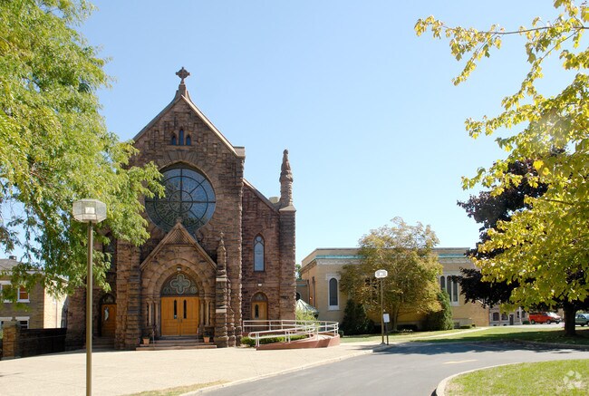
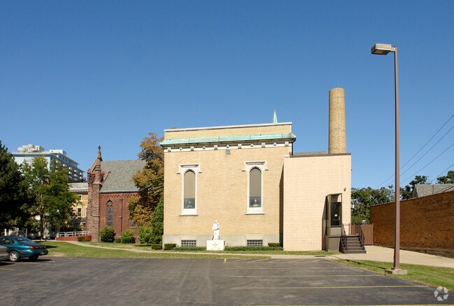
1035 Delaware Ave
140200-100-390-0001-020-121
386 N UTICA ST 291.57 N/L
Officebuilding
Erie
N-2R
New York
B and X Area of moderate flood hazard, usually the area between the limits of the 100-year and 500-year floods.
20.121
0
1.32 AC
2025
Buffalo CBD
006602
Buffalo/Niagara Falls
12,595 SF
Buffalo-Cheektowaga, NY
NEARBY LISTINGS FOR SALE OR LEASE
DEMOGRAPHICS near 1035 Delaware Ave
1 mile
3 mile
5 mile
2025 Total Population
31,000
153,924
318,614
2030 Population
30,939
151,267
313,354
Pop Growth 2025-2030
(0.20%)
(1.73%)
(1.65%)
Average Age
40
38
38
2025 Total Households
16,484
68,574
137,972
HH Growth 2025-2030
(0.02%)
(1.56%)
(1.58%)
Median Household Inc
$56,824
$46,093
$51,116
Avg Household Size
1.80
2.10
2.20
2025 Avg HH Vehicles
1.00
1.00
1.00
Median Home Value
$365,231
$237,026
$189,108
Median Year Built
1946
1946
1947
Nearby Places
Map Layers
Map Styles
 Street
 Aerial
Layers
 Traffic
 Biking
Places
Listings with unknown addresses are not visible on the map
- Restaurants
- Banks
- Shops
- Fitness
- Groceries
PUBLIC TRANSPORTATION
TRANSIT/SUBWAY
Utica (Buffalo Metro Rail - Niagara Frontier Transportation Authority Light Rail (Buffalo Metro Rail))
Drive
Walk
Distance
Utica (Buffalo Metro Rail - Niagara Frontier Transportation Authority Light Rail (Buffalo Metro Rail))
1 min
6 min
0.4 mi
Summer-Best (Buffalo Metro Rail - Niagara Frontier Transportation Authority Light Rail (Buffalo Metro Rail))
Drive
Walk
Distance
Summer-Best (Buffalo Metro Rail - Niagara Frontier Transportation Authority Light Rail (Buffalo Metro Rail))
2 min
15 min
0.8 mi
Delavan/Canisius College (Buffalo Metro Rail - Niagara Frontier Transportation Authority Light Rail (Buffalo Metro Rail))
Drive
Walk
Distance
Delavan/Canisius College (Buffalo Metro Rail - Niagara Frontier Transportation Authority Light Rail (Buffalo Metro Rail))
3 min
20 min
1.1 mi
COMMUTER RAIL
Buffalo (Empire Service - Amtrak, Maple Leaf - Amtrak)
Drive
Walk
Distance
Buffalo (Empire Service - Amtrak, Maple Leaf - Amtrak)
7 min
2.8 mi
Buffalo Depew Station (Empire Service - Amtrak, Lake Shore Limited - Amtrak, Maple Leaf - Amtrak)
Drive
Walk
Distance
Buffalo Depew Station (Empire Service - Amtrak, Lake Shore Limited - Amtrak, Maple Leaf - Amtrak)
17 min
9.1 mi
AIRPORT
Buffalo Niagara International
Drive
Walk
Distance
Buffalo Niagara International
18 min
9.8 mi
Niagara Falls International
Drive
Walk
Distance
Niagara Falls International
32 min
20.4 mi
Freight Ports
Port of Toledo
Drive
Walk
Distance
Port of Toledo
364 min
306.0 mi
Nearby Properties
Address
Land Use
TOTAL SIZE
Lot Size
Zoning
Address
Land Use
TOTAL SIZE
Lot Size
Zoning
6,120 SF
87.10 AC
D-IL
Address
Land Use
TOTAL SIZE
Lot Size
Zoning
704,072 SF
8.61 AC
N-1C
Address
Land Use
TOTAL SIZE
Lot Size
Zoning
Address
Land Use
TOTAL SIZE
Lot Size
Zoning
22,010 SF
D-M
Address
Land Use
TOTAL SIZE
Lot Size
Zoning
121,015 SF
92.60 AC
D-E
Address
Land Use
TOTAL SIZE
Lot Size
Zoning
686,000 SF
3.62 AC
N-2R
Address
Land Use
TOTAL SIZE
Lot Size
Zoning
870,511 SF
4.40 AC
D-M
Address
Land Use
TOTAL SIZE
Lot Size
Zoning
401,805 SF
2.04 AC
D-M
Address
Land Use
TOTAL SIZE
Lot Size
Zoning
8,317 SF
39.03 AC
SPLIT ZONE
Address
Land Use
TOTAL SIZE
Lot Size
Zoning
251,908 SF
D-M
Address
Land Use
TOTAL SIZE
Lot Size
Zoning
658,732 SF
1.83 AC
N-1D
Address
Land Use
TOTAL SIZE
Lot Size
Zoning
896,000 SF
3.99 AC
N-1D
Address
Land Use
TOTAL SIZE
Lot Size
Zoning
89,496 SF
6.44 AC
D-R
Address
Land Use
TOTAL SIZE
Lot Size
Zoning
569,121 SF
1.04 AC
N-1D
Address
Land Use
TOTAL SIZE
Lot Size
Zoning
561,196 SF
16 AC
D-M
Address
Land Use
TOTAL SIZE
Lot Size
Zoning
288,014 SF
3.68 AC
N-1C
Address
Land Use
TOTAL SIZE
Lot Size
Zoning
421,249 SF
10.62 AC
N-1D
Address
Land Use
TOTAL SIZE
Lot Size
Zoning
240,783 SF
1.63 AC
N-1D
Address
Land Use
TOTAL SIZE
Lot Size
Zoning
349,336 SF
2.70 AC
D-M
Address
Land Use
TOTAL SIZE
Lot Size
Zoning
12,641 SF
0.56 AC
N-2C
Address
Land Use
TOTAL SIZE
Lot Size
Zoning
465,720 SF
1.98 AC
N-1D
Address
Land Use
TOTAL SIZE
Lot Size
Zoning
156,870 SF
D-M
Address
Land Use
TOTAL SIZE
Lot Size
Zoning
321,589 SF
1.95 AC
N-1C
Address
Land Use
TOTAL SIZE
Lot Size
Zoning
19,608 SF
0.45 AC
N-3C
Address
Land Use
TOTAL SIZE
Lot Size
Zoning
4,312 SF
4.68 AC
N-1C
Address
Land Use
TOTAL SIZE
Lot Size
Zoning
7,752 SF
10.50 AC
D-R
Address
Land Use
TOTAL SIZE
Lot Size
Zoning
320,576 SF
1.90 AC
N-1S
Address
Land Use
TOTAL SIZE
Lot Size
Zoning
473,220 SF
8.18 AC
N-1C
Address
Land Use
TOTAL SIZE
Lot Size
Zoning
611,620 SF
2.20 AC
N-1S
Address
Land Use
TOTAL SIZE
Lot Size
Zoning
45,033 SF
1.18 AC
N-1C
The World's #1 Commercial Real Estate Marketplace
Connect with us
© 2026 CoStar Group
The information above has been obtained from sources believed reliable. While we do not doubt its accuracy we have not verified it and make no guarantee, warranty or representation about it. It is your responsibility to independently confirm its accuracy and completeness. Any projections, opinions, assumptions, or estimates used are for example only and do not represent the current or future performance of the property. The value of this transaction to you depends on tax and other factors which should be evaluated by your tax, financial, and legal advisors. You and your advisors should conduct a careful, independent investigation of the property to determine to your satisfaction the suitability of the property for your needs.