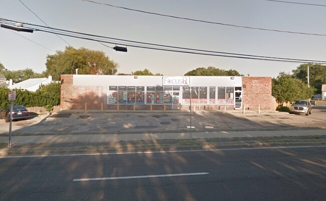
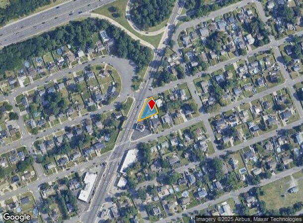
Property Record
1035 Straight Path, West Babylon, NY 11704
NEARBY LISTINGS FOR SALE OR LEASE
Property Detail
1035 Straight Path
Nassau County-Suffolk County, NY
F.M. 1733 PT OF LOT 49
0100-131-00-02-00-037-000
Suffolk
Commercialnec
New York
X
37
36103C0835H
0.17 AC
2024
Southwestern Suffolk
2024
Long Island (New York)
122901
DEMOGRAPHICS near 1035 Straight Path
1 mile
3 mile
5 mile
2024 Total Population
14,345
120,381
306,591
2029 Population
13,907
117,519
300,066
Pop Growth 2024-2029
(3.05%)
(2.38%)
(2.13%)
Average Age
40
40
41
2024 Total Households
4,465
37,296
100,806
HH Growth 2024-2029
(3.34%)
(2.58%)
(2.33%)
Median Household Inc
$114,384
$109,321
$114,409
Avg Household Size
3.10
3.10
2.90
2024 Avg HH Vehicles
2.00
2.00
2.00
Median Home Value
$427,172
$440,825
$473,468
Median Year Built
1958
1962
1960
Nearby Places
Map Layers
Map Styles
 Street
 Aerial
Transit
 Traffic
 Biking
Places
Listings with unknown addresses are not visible on the map
- Restaurants
- Banks
- Shops
- Fitness
- Groceries
PUBLIC TRANSPORTATION
COMMUTER RAIL
Wyandanch Station (Ronkonkoma Branch - Long Island Rail Road)
Drive
Walk
Distance
Wyandanch Station (Ronkonkoma Branch - Long Island Rail Road)
4 min
2.3 mi
Pinelawn Station (Ronkonkoma Branch - Long Island Rail Road)
Drive
Walk
Distance
Pinelawn Station (Ronkonkoma Branch - Long Island Rail Road)
5 min
3.3 mi
AIRPORT
Long Island MacArthur
Drive
Walk
Distance
Long Island MacArthur
26 min
18.7 mi
John F Kennedy International
Drive
Walk
Distance
John F Kennedy International
37 min
26.9 mi
LaGuardia
Drive
Walk
Distance
LaGuardia
47 min
33.9 mi
Freight Ports
NY - Red Hook Container Terminal
Drive
Walk
Distance
NY - Red Hook Container Terminal
57 min
38.3 mi
SALE & LEASE HISTORY
LISTING DATE
SALE/LEASE

Oct 23, 2019
For Lease
May 21, 2020
For Lease
Nearby Properties
Address
Land Use
TOTAL SIZE
Lot Size
Zoning
Address
Land Use
TOTAL SIZE
Lot Size
Zoning
2,131 SF
0.64 AC
R20
Address
Land Use
TOTAL SIZE
Lot Size
Zoning
2,304 SF
4.26 AC
R80
Address
Land Use
TOTAL SIZE
Lot Size
Zoning
3,351 SF
1.99 AC
R40
Address
Land Use
TOTAL SIZE
Lot Size
Zoning
3,898 SF
0.90 AC
R40
Address
Land Use
TOTAL SIZE
Lot Size
Zoning
3,366 SF
0.64 AC
R40
Address
Land Use
TOTAL SIZE
Lot Size
Zoning
4,571 SF
1.21 AC
R40
Address
Land Use
TOTAL SIZE
Lot Size
Zoning
756 SF
0.36 AC
B1
Address
Land Use
TOTAL SIZE
Lot Size
Zoning
24.90 AC
B
Address
Land Use
TOTAL SIZE
Lot Size
Zoning
3,489 SF
0.41 AC
CR40
Address
Land Use
TOTAL SIZE
Lot Size
Zoning
2,384 SF
1.44 AC
R40
Address
Land Use
TOTAL SIZE
Lot Size
Zoning
2,062 SF
0.89 AC
R40
Address
Land Use
TOTAL SIZE
Lot Size
Zoning
2,097 SF
0.24 AC
R20
Address
Land Use
TOTAL SIZE
Lot Size
Zoning
2,356 SF
0.34 AC
R15
Address
Land Use
TOTAL SIZE
Lot Size
Zoning
6.37 AC
BUS3
Address
Land Use
TOTAL SIZE
Lot Size
Zoning
1,407 SF
0.35 AC
R40
Address
Land Use
TOTAL SIZE
Lot Size
Zoning
16.71 AC
GSF
Address
Land Use
TOTAL SIZE
Lot Size
Zoning
1,390 SF
0.17 AC
R10
Address
Land Use
TOTAL SIZE
Lot Size
Zoning
2,603 SF
1.41 AC
CR120
Address
Land Use
TOTAL SIZE
Lot Size
Zoning
1,908 SF
0.45 AC
R40
Address
Land Use
TOTAL SIZE
Lot Size
Zoning
2,013 SF
0.23 AC
R15
Address
Land Use
TOTAL SIZE
Lot Size
Zoning
2,780 SF
0.43 AC
R20
Address
Land Use
TOTAL SIZE
Lot Size
Zoning
336,442 SF
43.50 AC
G
Address
Land Use
TOTAL SIZE
Lot Size
Zoning
850 SF
0.54 AC
R20
Address
Land Use
TOTAL SIZE
Lot Size
Zoning
1,558 SF
0.37 AC
VILLA
Address
Land Use
TOTAL SIZE
Lot Size
Zoning
2,186 SF
0.34 AC
R20
Address
Land Use
TOTAL SIZE
Lot Size
Zoning
1,274 SF
0.27 AC
R20
Address
Land Use
TOTAL SIZE
Lot Size
Zoning
2,388 SF
0.36 AC
B1
Address
Land Use
TOTAL SIZE
Lot Size
Zoning
1,048 SF
0.90 AC
R40
Address
Land Use
TOTAL SIZE
Lot Size
Zoning
1,980 SF
0.33 AC
R40
Address
Land Use
TOTAL SIZE
Lot Size
Zoning
4,136 SF
0.26 AC
R15
The World's #1 Commercial Real Estate Marketplace
Connect with us
© 2026 CoStar Group
The information above has been obtained from sources believed reliable. While we do not doubt its accuracy we have not verified it and make no guarantee, warranty or representation about it. It is your responsibility to independently confirm its accuracy and completeness. Any projections, opinions, assumptions, or estimates used are for example only and do not represent the current or future performance of the property. The value of this transaction to you depends on tax and other factors which should be evaluated by your tax, financial, and legal advisors. You and your advisors should conduct a careful, independent investigation of the property to determine to your satisfaction the suitability of the property for your needs.