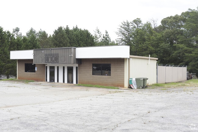
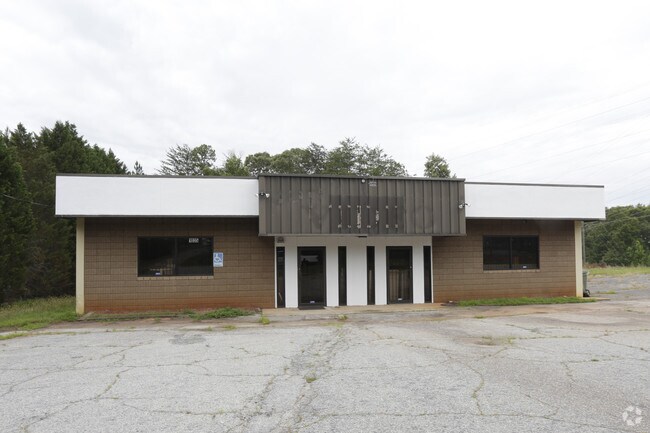
Property Record
1035 W Main St, Central, SC 29630
Property Detail
1035 W Main St
4065-14-23-9728
LOT C6 SE/SIDE HWY 93 PLAT 23/750
Medicalbuilding
PICKENS
GENERAL CO
South Carolina
B and X Area of moderate flood hazard, usually the area between the limits of the 100-year and 500-year floods.
c6
2025
0.61 AC
2025
Pickens County
011105
Greenville/Spartanburg
6,144 SF
Greenville-Anderson-Greer, SC
NEARBY LISTINGS FOR SALE OR LEASE
DEMOGRAPHICS near 1035 W Main St
1 mile
3 mile
5 mile
2025 Total Population
4,340
19,097
41,079
2030 Population
4,480
19,771
42,648
Pop Growth 2025-2030
+ 3.23%
+ 3.53%
+ 3.82%
Average Age
32
35
35
2025 Total Households
1,858
8,073
15,366
HH Growth 2025-2030
+ 3.55%
+ 3.80%
+ 4.35%
Median Household Inc
$45,309
$51,935
$54,623
Avg Household Size
2.30
2.20
2.30
2025 Avg HH Vehicles
2.00
2.00
2.00
Median Home Value
$243,090
$297,066
$281,747
Median Year Built
1993
1991
1990
Nearby Places
Map Layers
Map Styles
 Street
 Aerial
Layers
 Traffic
 Biking
Places
Listings with unknown addresses are not visible on the map
- Restaurants
- Banks
- Shops
- Fitness
- Groceries
PUBLIC TRANSPORTATION
COMMUTER RAIL
Drive
Walk
Distance
8 min
3.7 mi
AIRPORT
Greenville Spartanburg International
Drive
Walk
Distance
Greenville Spartanburg International
61 min
43.0 mi
Nearby Properties
Address
Land Use
TOTAL SIZE
Lot Size
Zoning
Address
Land Use
TOTAL SIZE
Lot Size
Zoning
5,208 SF
11.33 AC
RM16
Address
Land Use
TOTAL SIZE
Lot Size
Zoning
11,881 SF
2.02 AC
GENERAL CO
Address
Land Use
TOTAL SIZE
Lot Size
Zoning
61,130 SF
19.26 AC
PD
Address
Land Use
TOTAL SIZE
Lot Size
Zoning
7,692 SF
0.40 AC
RIL
Address
Land Use
TOTAL SIZE
Lot Size
Zoning
24,882 SF
12.94 AC
PD
Address
Land Use
TOTAL SIZE
Lot Size
Zoning
54,420 SF
9.52 AC
PD16
Address
Land Use
TOTAL SIZE
Lot Size
Zoning
20,927 SF
2.66 AC
GC
Address
Land Use
TOTAL SIZE
Lot Size
Zoning
3,712 SF
1.55 AC
RM 4 MULTI
Address
Land Use
TOTAL SIZE
Lot Size
Zoning
7,070 SF
2.59 AC
GENERAL CO
Address
Land Use
TOTAL SIZE
Lot Size
Zoning
9,112 SF
10.93 AC
RM 3 MULTI
Address
Land Use
TOTAL SIZE
Lot Size
Zoning
4.97 AC
PD
Address
Land Use
TOTAL SIZE
Lot Size
Zoning
3,160 SF
2.30 AC
RM16 RESID
Address
Land Use
TOTAL SIZE
Lot Size
Zoning
103.43 AC
Address
Land Use
TOTAL SIZE
Lot Size
Zoning
17 AC
RIL RESEAR
Address
Land Use
TOTAL SIZE
Lot Size
Zoning
20,686 SF
15.84 AC
RM16
Address
Land Use
TOTAL SIZE
Lot Size
Zoning
2,498 SF
8.27 AC
CP2
Address
Land Use
TOTAL SIZE
Lot Size
Zoning
249,600 SF
12.61 AC
RM16
Address
Land Use
TOTAL SIZE
Lot Size
Zoning
3,542 SF
0.80 AC
GC
Address
Land Use
TOTAL SIZE
Lot Size
Zoning
6,377 SF
2.01 AC
GC
Address
Land Use
TOTAL SIZE
Lot Size
Zoning
22,722 SF
12.68 AC
PD
Address
Land Use
TOTAL SIZE
Lot Size
Zoning
10.09 AC
GC
Address
Land Use
TOTAL SIZE
Lot Size
Zoning
2,111 SF
10.67 AC
RM16 RESID
Address
Land Use
TOTAL SIZE
Lot Size
Zoning
36.40 AC
RM 1 TWO F
Address
Land Use
TOTAL SIZE
Lot Size
Zoning
42,049 SF
6.26 AC
PD
Address
Land Use
TOTAL SIZE
Lot Size
Zoning
54,244 SF
1.17 AC
RIL
Address
Land Use
TOTAL SIZE
Lot Size
Zoning
196,017 SF
25.24 AC
GC
Address
Land Use
TOTAL SIZE
Lot Size
Zoning
69,132 SF
2.21 AC
CP2
Address
Land Use
TOTAL SIZE
Lot Size
Zoning
29,631 SF
5.22 AC
PDD
Address
Land Use
TOTAL SIZE
Lot Size
Zoning
1,141 SF
25.98 AC
RM 3 MULTI
The World's #1 Commercial Real Estate Marketplace
Connect with us
© 2026 CoStar Group
The information above has been obtained from sources believed reliable. While we do not doubt its accuracy we have not verified it and make no guarantee, warranty or representation about it. It is your responsibility to independently confirm its accuracy and completeness. Any projections, opinions, assumptions, or estimates used are for example only and do not represent the current or future performance of the property. The value of this transaction to you depends on tax and other factors which should be evaluated by your tax, financial, and legal advisors. You and your advisors should conduct a careful, independent investigation of the property to determine to your satisfaction the suitability of the property for your needs.