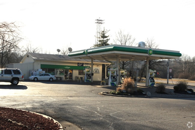
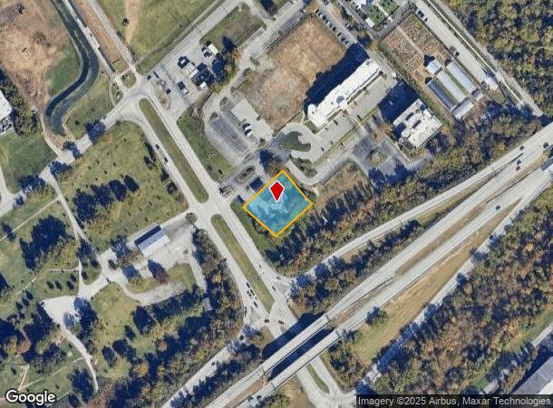
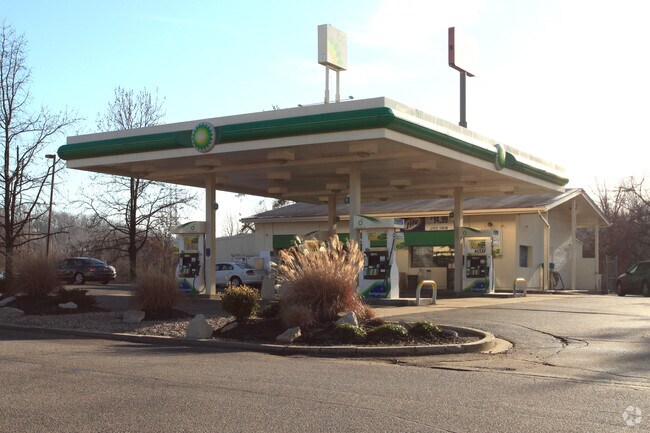
Property Record
1035 Zorn Ave, Louisville, KY 40207
NEARBY LISTINGS FOR SALE OR LEASE
Property Detail
1035 Zorn Ave
088K00910000
.6336 AC+- TRACT D MINOR PLAT DB 5834 X 706 ZORN AVE GULF OIL LEASE
Storebuilding
Jefferson
AE
Kentucky
21111C0027F
0.63 AC
2024
Westport Rd/Brownsboro Rd
2024
Louisville
007400
Louisville-Jefferson County, KY-IN
1,860 SF
DEMOGRAPHICS near 1035 Zorn Ave
1 Mile
3 Mile
5 Mile
2024 Total Population
4,436
69,517
208,785
2029 Population
4,417
70,812
211,267
Pop Growth 2024-2029
(0.43%)
+ 1.86%
+ 1.19%
Average Age
40
41
41
2024 Total Households
2,242
32,918
96,920
HH Growth 2024-2029
(0.40%)
+ 1.74%
+ 1.14%
Median Household Inc
$62,158
$59,997
$59,910
Avg Household Size
1.90
2.00
2.00
2024 Avg HH Vehicles
2.00
2.00
2.00
Median Home Value
$233,625
$280,206
$263,123
Median Year Built
1971
1962
1960
Nearby Places
Map Layers
Map Styles
 Street
 Aerial
- Restaurants
- Banks
- Shops
- Fitness
- Groceries
PUBLIC TRANSPORTATION
AIRPORT
Louisville Muhammad Ali International
DRIVE
WALK
Distance
Louisville Muhammad Ali International
19 min
10.6 mi
Freight Ports
Port of Toledo
DRIVE
WALK
Distance
Port of Toledo
347 min
300.9 mi
Nearby Properties
Address
Land Use
TOTAL SIZE
Lot Size
Zoning
Address
Land Use
TOTAL SIZE
Lot Size
Zoning
106,330 SF
9.44 AC
M3-INDUSTR
Address
Land Use
TOTAL SIZE
Lot Size
Zoning
4,337 SF
3.71 AC
(C2)COMMER
Address
Land Use
TOTAL SIZE
Lot Size
Zoning
23.42 AC
(W
Address
Land Use
TOTAL SIZE
Lot Size
Zoning
21,767 SF
1.47 AC
EZ1-ENTERP
Address
Land Use
TOTAL SIZE
Lot Size
Zoning
59,648 SF
1.66 AC
OR3-OFFICE
Address
Land Use
TOTAL SIZE
Lot Size
Zoning
34.06 AC
Address
Land Use
TOTAL SIZE
Lot Size
Zoning
50,946 SF
2.66 AC
(CM)COMMER
Address
Land Use
TOTAL SIZE
Lot Size
Zoning
6,254 SF
1.48 AC
C2-COMMERC
Address
Land Use
TOTAL SIZE
Lot Size
Zoning
400 SF
13.92 AC
R6-RESIDEN
Address
Land Use
TOTAL SIZE
Lot Size
Zoning
24,302 SF
0.27 AC
CM-COMMERC
Address
Land Use
TOTAL SIZE
Lot Size
Zoning
109,470 SF
2.27 AC
Address
Land Use
TOTAL SIZE
Lot Size
Zoning
28,408 SF
1.55 AC
EZ1-ENTERP
Address
Land Use
TOTAL SIZE
Lot Size
Zoning
2.81 AC
Address
Land Use
TOTAL SIZE
Lot Size
Zoning
176,448 SF
2.45 AC
Address
Land Use
TOTAL SIZE
Lot Size
Zoning
2,032 SF
6.48 AC
R7-RESIDEN
Address
Land Use
TOTAL SIZE
Lot Size
Zoning
Address
Land Use
TOTAL SIZE
Lot Size
Zoning
0.13 AC
C2-COMMERC
Address
Land Use
TOTAL SIZE
Lot Size
Zoning
4,750 SF
9.60 AC
OR2-OFFICE
Address
Land Use
TOTAL SIZE
Lot Size
Zoning
16,221 SF
2.40 AC
Address
Land Use
TOTAL SIZE
Lot Size
Zoning
303,047 SF
7.21 AC
Address
Land Use
TOTAL SIZE
Lot Size
Zoning
11.97 AC
Address
Land Use
TOTAL SIZE
Lot Size
Zoning
11.90 AC
Address
Land Use
TOTAL SIZE
Lot Size
Zoning
1.59 AC
U-N-URBAN
Address
Land Use
TOTAL SIZE
Lot Size
Zoning
17,520 SF
12.62 AC
Address
Land Use
TOTAL SIZE
Lot Size
Zoning
104,082 SF
14.78 AC
EZ1-ENTERP
Address
Land Use
TOTAL SIZE
Lot Size
Zoning
10,172 SF
1.58 AC
C2-COMMERC
Address
Land Use
TOTAL SIZE
Lot Size
Zoning
48,128 SF
21.17 AC
R5-RESIDEN
Address
Land Use
TOTAL SIZE
Lot Size
Zoning
7,760 SF
0.86 AC
C2-COMMERC
Address
Land Use
TOTAL SIZE
Lot Size
Zoning
19,610 SF
2.16 AC
R7-RESIDEN
Address
Land Use
TOTAL SIZE
Lot Size
Zoning
8.31 AC
(CM)COMMER
The World's #1 Commercial Real Estate Marketplace
Connect with us
© 2025 CoStar Group
The information above has been obtained from sources believed reliable. While we do not doubt its accuracy we have not verified it and make no guarantee, warranty or representation about it. It is your responsibility to independently confirm its accuracy and completeness. Any projections, opinions, assumptions, or estimates used are for example only and do not represent the current or future performance of the property. The value of this transaction to you depends on tax and other factors which should be evaluated by your tax, financial, and legal advisors. You and your advisors should conduct a careful, independent investigation of the property to determine to your satisfaction the suitability of the property for your needs.