Property Record
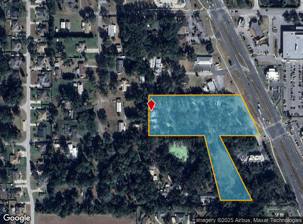
10366 Se Us Highway 441, Belleview, FL 34420
This Property Is For Sale
NEARBY LISTINGS FOR SALE OR LEASE
Property Detail
10366 Se Us Highway 441
37209-000-00
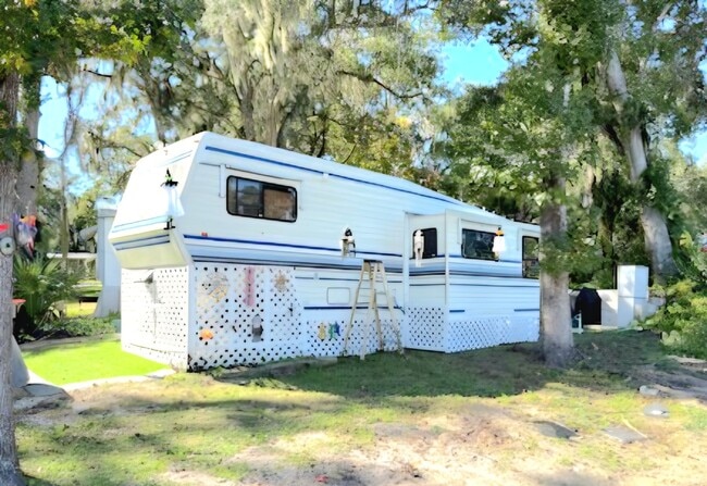
Silver Oaks Campground
Campgroundrvpark
SEC 26 TWP 16 RGE 22 N 860.89 FT OF SE 1/4 OF NE 1/4 LYING W OF HWY 441 EXC THE N 573.92 FT THEREOF & FROM THE INTERSECTION OF THE S BDY OF THE SE 1/4 OF NE 1/4 WITH ROW OF US 441 TH W ALONG SAID S BDY 280.10 FT FOR THE POB FROM THE POB TH NWLY PARAL
AE
Marion
12083C0729D
Florida
2024
6.96 AC
2024
Outlying Marion County
001106
Ocala
2,819 SF
Ocala, FL
DEMOGRAPHICS near 10366 Se Us Highway 441
1 Mile
3 Mile
5 Mile
2024 Total Population
3,765
19,450
59,276
2029 Population
4,308
22,091
67,503
Pop Growth 2024-2029
+ 14.42%
+ 13.58%
+ 13.88%
Average Age
42
41
41
2024 Total Households
1,514
7,702
22,875
HH Growth 2024-2029
+ 14.40%
+ 13.50%
+ 13.81%
Median Household Inc
$60,371
$58,276
$57,279
Avg Household Size
2.50
2.50
2.50
2024 Avg HH Vehicles
2.00
2.00
2.00
Median Home Value
$210,991
$193,974
$176,526
Median Year Built
1992
1990
1992
Nearby Places
- Restaurants
- Banks
- Shops
- Fitness
- Groceries
Nearby Properties
Address
Land Use
TOTAL SIZE
Lot Size
Zoning
Address
Land Use
TOTAL SIZE
Lot Size
Zoning
364,073 SF
119.27 AC
A1
Address
Land Use
TOTAL SIZE
Lot Size
Zoning
64,086 SF
28.11 AC
A1
Address
Land Use
TOTAL SIZE
Lot Size
Zoning
680,069 SF
62.96 AC
B5
Address
Land Use
TOTAL SIZE
Lot Size
Zoning
83,881 SF
16.60 AC
A1
Address
Land Use
TOTAL SIZE
Lot Size
Zoning
76,351 SF
14.60 AC
GU
Address
Land Use
TOTAL SIZE
Lot Size
Zoning
54,297 SF
6.32 AC
B2
Address
Land Use
TOTAL SIZE
Lot Size
Zoning
52,400 SF
6.50 AC
R3
Address
Land Use
TOTAL SIZE
Lot Size
Zoning
97,449 SF
13.29 AC
B2
Address
Land Use
TOTAL SIZE
Lot Size
Zoning
540 AC
A1
Address
Land Use
TOTAL SIZE
Lot Size
Zoning
28,457 SF
3.30 AC
B4
Address
Land Use
TOTAL SIZE
Lot Size
Zoning
30,862 SF
8.09 AC
B2
Address
Land Use
TOTAL SIZE
Lot Size
Zoning
501 SF
428.83 AC
B4
Address
Land Use
TOTAL SIZE
Lot Size
Zoning
22,960 SF
3.09 AC
B4
Address
Land Use
TOTAL SIZE
Lot Size
Zoning
43,281 SF
21.36 AC
B2
Address
Land Use
TOTAL SIZE
Lot Size
Zoning
66,190 SF
6.41 AC
B5
Address
Land Use
TOTAL SIZE
Lot Size
Zoning
50,776 SF
12.05 AC
B2
Address
Land Use
TOTAL SIZE
Lot Size
Zoning
13,858 SF
1.83 AC
B4
Address
Land Use
TOTAL SIZE
Lot Size
Zoning
98,428 SF
10 AC
M2
Address
Land Use
TOTAL SIZE
Lot Size
Zoning
8,194 SF
10.98 AC
A1
Address
Land Use
TOTAL SIZE
Lot Size
Zoning
18,213 SF
6.88 AC
GU
Address
Land Use
TOTAL SIZE
Lot Size
Zoning
34,277 SF
14.94 AC
B5
Address
Land Use
TOTAL SIZE
Lot Size
Zoning
43,882 SF
3.93 AC
B4
Address
Land Use
TOTAL SIZE
Lot Size
Zoning
60,978 SF
6.88 AC
PUD
Address
Land Use
TOTAL SIZE
Lot Size
Zoning
40,000 SF
4.06 AC
M1
Address
Land Use
TOTAL SIZE
Lot Size
Zoning
6,709 SF
133.58 AC
A1
Address
Land Use
TOTAL SIZE
Lot Size
Zoning
67,198 SF
9 AC
B5
Address
Land Use
TOTAL SIZE
Lot Size
Zoning
9,687 SF
118.25 AC
B5
Address
Land Use
TOTAL SIZE
Lot Size
Zoning
13,920 SF
2.09 AC
B2
Address
Land Use
TOTAL SIZE
Lot Size
Zoning
24,816 SF
3.34 AC
R3
Address
Land Use
TOTAL SIZE
Lot Size
Zoning
310 AC
A1
The World's #1 Commercial Real Estate Marketplace
Connect with us
© 2025 CoStar Group
The information above has been obtained from sources believed reliable. While we do not doubt its accuracy we have not verified it and make no guarantee, warranty or representation about it. It is your responsibility to independently confirm its accuracy and completeness. Any projections, opinions, assumptions, or estimates used are for example only and do not represent the current or future performance of the property. The value of this transaction to you depends on tax and other factors which should be evaluated by your tax, financial, and legal advisors. You and your advisors should conduct a careful, independent investigation of the property to determine to your satisfaction the suitability of the property for your needs.