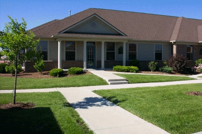
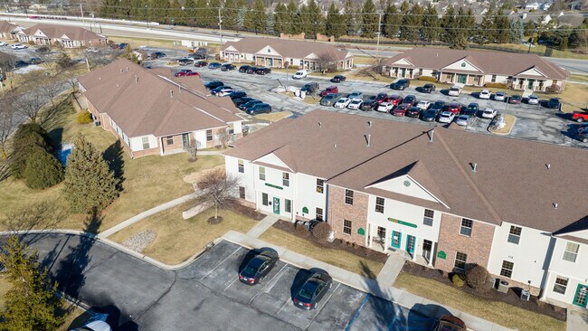
Property Record
10351 Dawsons Creek Blvd, Fort Wayne, IN 46825
NEARBY LISTINGS FOR SALE OR LEASE
Property Detail
10351 Dawsons Creek Blvd
02-07-02-201-012.000-073
Dawsons Creek Professional Village
Officebuilding
BUILDING 4 UNIT B DAWSONS CREEK PROFESSIONAL VILLAGE UPPER LEVEL
X
Allen
18003C0170G
Indiana
2023
0.04 AC
2024
Outlying Allen County
010707
Fort Wayne
1,894 SF
Fort Wayne, IN
DEMOGRAPHICS near 10351 Dawsons Creek Blvd
1 Mile
3 Mile
5 Mile
2024 Total Population
6,721
47,265
107,278
2029 Population
6,944
49,144
112,013
Pop Growth 2024-2029
+ 3.32%
+ 3.98%
+ 4.41%
Average Age
41
39
38
2024 Total Households
2,814
18,350
42,502
HH Growth 2024-2029
+ 3.45%
+ 4.08%
+ 4.48%
Median Household Inc
$83,683
$85,147
$72,046
Avg Household Size
2.40
2.50
2.40
2024 Avg HH Vehicles
2.00
2.00
2.00
Median Home Value
$235,253
$214,388
$192,474
Median Year Built
1994
1994
1990
Nearby Places
Map Layers
Map Styles
 Street
 Aerial
- Restaurants
- Banks
- Shops
- Fitness
- Groceries
PUBLIC TRANSPORTATION
AIRPORT
Fort Wayne International
DRIVE
WALK
Distance
Fort Wayne International
33 min
21.6 mi
Freight Ports
Port of Toledo
DRIVE
WALK
Distance
Port of Toledo
141 min
107.0 mi
SALE & LEASE HISTORY
LISTING DATE
SALE/LEASE

Oct 26, 2022
For Lease
Oct 16, 2018
For Lease
Oct 02, 2020
For Lease
Nov 13, 2018
For Lease
Nov 11, 2019
For Lease
Nov 11, 2019
For Sale
Jun 18, 2018
For Sale
Jun 18, 2018
For Lease
Jul 13, 2022
For Lease
Feb 21, 2025
For Sale
Nearby Properties
Address
Land Use
TOTAL SIZE
Lot Size
Zoning
Address
Land Use
TOTAL SIZE
Lot Size
Zoning
1,230,577 SF
21.07 AC
Address
Land Use
TOTAL SIZE
Lot Size
Zoning
162,697 SF
14 AC
Address
Land Use
TOTAL SIZE
Lot Size
Zoning
28,590 SF
55.23 AC
Address
Land Use
TOTAL SIZE
Lot Size
Zoning
242,556 SF
17.18 AC
Address
Land Use
TOTAL SIZE
Lot Size
Zoning
206,109 SF
12.21 AC
Address
Land Use
TOTAL SIZE
Lot Size
Zoning
179,472 SF
23.26 AC
Address
Land Use
TOTAL SIZE
Lot Size
Zoning
293,400 SF
16.75 AC
Address
Land Use
TOTAL SIZE
Lot Size
Zoning
152,404 SF
27.47 AC
Address
Land Use
TOTAL SIZE
Lot Size
Zoning
59,089 SF
28.68 AC
Address
Land Use
TOTAL SIZE
Lot Size
Zoning
57,938 SF
34.20 AC
Address
Land Use
TOTAL SIZE
Lot Size
Zoning
116,411 SF
5.08 AC
Address
Land Use
TOTAL SIZE
Lot Size
Zoning
116,507 SF
6.54 AC
Address
Land Use
TOTAL SIZE
Lot Size
Zoning
125,604 SF
0.82 AC
Address
Land Use
TOTAL SIZE
Lot Size
Zoning
106,005 SF
25.50 AC
Address
Land Use
TOTAL SIZE
Lot Size
Zoning
185,729 SF
14 AC
Address
Land Use
TOTAL SIZE
Lot Size
Zoning
81,654 SF
13.07 AC
Address
Land Use
TOTAL SIZE
Lot Size
Zoning
88,120 SF
9.32 AC
Address
Land Use
TOTAL SIZE
Lot Size
Zoning
79,886 SF
5.85 AC
Address
Land Use
TOTAL SIZE
Lot Size
Zoning
111,186 SF
1 AC
Address
Land Use
TOTAL SIZE
Lot Size
Zoning
156,706 SF
20.04 AC
Address
Land Use
TOTAL SIZE
Lot Size
Zoning
125,356 SF
16.20 AC
Address
Land Use
TOTAL SIZE
Lot Size
Zoning
62,214 SF
4.18 AC
Address
Land Use
TOTAL SIZE
Lot Size
Zoning
222,349 SF
32.27 AC
Address
Land Use
TOTAL SIZE
Lot Size
Zoning
248,016 SF
50.67 AC
Address
Land Use
TOTAL SIZE
Lot Size
Zoning
196,815 SF
32.76 AC
Address
Land Use
TOTAL SIZE
Lot Size
Zoning
66,101 SF
7.49 AC
Address
Land Use
TOTAL SIZE
Lot Size
Zoning
67,032 SF
16.06 AC
Address
Land Use
TOTAL SIZE
Lot Size
Zoning
58,254 SF
4.47 AC
Address
Land Use
TOTAL SIZE
Lot Size
Zoning
86,016 SF
6.89 AC
Address
Land Use
TOTAL SIZE
Lot Size
Zoning
52,910 SF
4.91 AC
The World's #1 Commercial Real Estate Marketplace
Connect with us
© 2025 CoStar Group
The information above has been obtained from sources believed reliable. While we do not doubt its accuracy we have not verified it and make no guarantee, warranty or representation about it. It is your responsibility to independently confirm its accuracy and completeness. Any projections, opinions, assumptions, or estimates used are for example only and do not represent the current or future performance of the property. The value of this transaction to you depends on tax and other factors which should be evaluated by your tax, financial, and legal advisors. You and your advisors should conduct a careful, independent investigation of the property to determine to your satisfaction the suitability of the property for your needs.