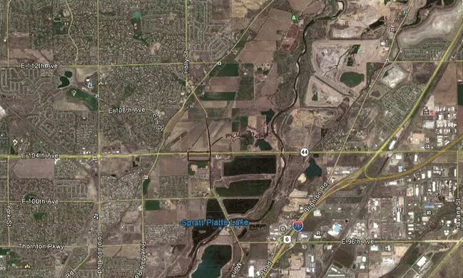
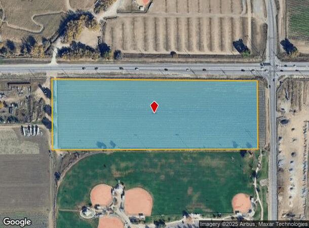
Property Record
10351 Mc Kay Rd, Thornton, CO
NEARBY LISTINGS FOR SALE OR LEASE
Property Detail
10351 Mc Kay Rd
Denver-Aurora-Lakewood, CO
Agriculture Prop
1721-17-0-00-048
SECT,TWN,RNG:17-2-67 DESC: NW4 NW4 EXC HIWAY AND N2 N2 SW4 NW4 INCL D L AND NW R R EXC PARCS AND EXC RD 9/978A (2013 - ENTIRE PARCEL TO THE CITY OF THORNTON (EXEMPT) PER DEED IN RECEPTION NO 2013000041659. PRORATED FOR 135 DAYS FOR 2013 AND FULL EXEM
Municipalproperty
Adams
X
Colorado
08001C0318J
9.98 AC
0
North Denver
2024
Denver
0091031000
DEMOGRAPHICS near 10351 Mc Kay Rd
1 Mile
3 Mile
5 Mile
2024 Total Population
5,874
87,242
241,446
2029 Population
6,018
90,367
250,251
Pop Growth 2024-2029
+ 2.45%
+ 3.58%
+ 3.65%
Average Age
35
36
36
2024 Total Households
1,805
29,552
82,711
HH Growth 2024-2029
+ 2.44%
+ 3.64%
+ 3.72%
Median Household Inc
$75,269
$86,061
$82,567
Avg Household Size
3.20
2.90
2.90
2024 Avg HH Vehicles
2.00
2.00
2.00
Median Home Value
$315,785
$392,828
$400,592
Median Year Built
1988
1992
1991
Nearby Places
Map Layers
Map Styles
 Street
 Aerial
- Restaurants
- Banks
- Shops
- Fitness
- Groceries
PUBLIC TRANSPORTATION
COMMUTER RAIL
Thornton Crossroads - 104Th Station Track 1 (Union Station to Eastlake & 124th Station - Regional Transportation District)
DRIVE
WALK
Distance
Thornton Crossroads - 104Th Station Track 1 (Union Station to Eastlake & 124th Station - Regional Transportation District)
3 min
1.4 mi
Northglenn - 112Th Station Track 1 (Union Station to Eastlake & 124th Station - Regional Transportation District)
DRIVE
WALK
Distance
Northglenn - 112Th Station Track 1 (Union Station to Eastlake & 124th Station - Regional Transportation District)
6 min
3.3 mi
AIRPORT
Denver International
DRIVE
WALK
Distance
Denver International
28 min
17.9 mi
Freight Ports
Tulsa Port Of Catoosa
DRIVE
WALK
Distance
Tulsa Port Of Catoosa
733 min
712.0 mi
Nearby Properties
Address
Land Use
TOTAL SIZE
Lot Size
Zoning
Address
Land Use
TOTAL SIZE
Lot Size
Zoning
106,680 SF
17.39 AC
Address
Land Use
TOTAL SIZE
Lot Size
Zoning
8,556 SF
382.73 AC
A3
Address
Land Use
TOTAL SIZE
Lot Size
Zoning
549,866 SF
33.82 AC
Address
Land Use
TOTAL SIZE
Lot Size
Zoning
282,144 SF
4.01 AC
Address
Land Use
TOTAL SIZE
Lot Size
Zoning
616.10 AC
A3
Address
Land Use
TOTAL SIZE
Lot Size
Zoning
330,176 SF
17.12 AC
Address
Land Use
TOTAL SIZE
Lot Size
Zoning
328,674 SF
47.13 AC
Address
Land Use
TOTAL SIZE
Lot Size
Zoning
329,940 SF
10.31 AC
Address
Land Use
TOTAL SIZE
Lot Size
Zoning
153,301 SF
26.75 AC
Address
Land Use
TOTAL SIZE
Lot Size
Zoning
512,780 SF
25.11 AC
Address
Land Use
TOTAL SIZE
Lot Size
Zoning
250,523 SF
70.73 AC
I1
Address
Land Use
TOTAL SIZE
Lot Size
Zoning
172,816 SF
59.89 AC
Address
Land Use
TOTAL SIZE
Lot Size
Zoning
258,279 SF
70.11 AC
I2
Address
Land Use
TOTAL SIZE
Lot Size
Zoning
547,908 SF
12.24 AC
Address
Land Use
TOTAL SIZE
Lot Size
Zoning
411,708 SF
22.39 AC
Address
Land Use
TOTAL SIZE
Lot Size
Zoning
219,959 SF
10 AC
Address
Land Use
TOTAL SIZE
Lot Size
Zoning
445,016 SF
23.77 AC
Address
Land Use
TOTAL SIZE
Lot Size
Zoning
208,864 SF
19.26 AC
Address
Land Use
TOTAL SIZE
Lot Size
Zoning
459,283 SF
16.88 AC
Address
Land Use
TOTAL SIZE
Lot Size
Zoning
311,274 SF
18.75 AC
Address
Land Use
TOTAL SIZE
Lot Size
Zoning
86,977 SF
4.14 AC
Address
Land Use
TOTAL SIZE
Lot Size
Zoning
295,688 SF
20.66 AC
Address
Land Use
TOTAL SIZE
Lot Size
Zoning
204,000 SF
9.96 AC
Address
Land Use
TOTAL SIZE
Lot Size
Zoning
199,500 SF
15.03 AC
Address
Land Use
TOTAL SIZE
Lot Size
Zoning
72,628 SF
12.60 AC
Address
Land Use
TOTAL SIZE
Lot Size
Zoning
373,767 SF
18.87 AC
Address
Land Use
TOTAL SIZE
Lot Size
Zoning
67,395 SF
13.38 AC
Address
Land Use
TOTAL SIZE
Lot Size
Zoning
158,001 SF
20.40 AC
Address
Land Use
TOTAL SIZE
Lot Size
Zoning
128,257 SF
11.85 AC
Address
Land Use
TOTAL SIZE
Lot Size
Zoning
96,628 SF
4.35 AC
The World's #1 Commercial Real Estate Marketplace
Connect with us
© 2025 CoStar Group
The information above has been obtained from sources believed reliable. While we do not doubt its accuracy we have not verified it and make no guarantee, warranty or representation about it. It is your responsibility to independently confirm its accuracy and completeness. Any projections, opinions, assumptions, or estimates used are for example only and do not represent the current or future performance of the property. The value of this transaction to you depends on tax and other factors which should be evaluated by your tax, financial, and legal advisors. You and your advisors should conduct a careful, independent investigation of the property to determine to your satisfaction the suitability of the property for your needs.