Property Record
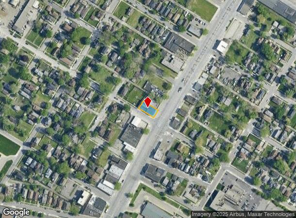
10356 W Jefferson Ave, River Rouge, MI 48218

NEARBY LISTINGS FOR SALE OR LEASE
Property Detail
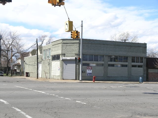
10356 W Jefferson Ave
Detroit-Warren-Dearborn, MI
Furgasons
50-007-06-0011-000
114F11 BL4 LOT 11 BLOCK 4 2ND ADDITION TO FURGASONS SUB BLOCK PC 114 L18 P89 WCR
Storebuilding
Wayne
X
Michigan
26163C0269F
11
2024
0.12 AC
2025
Downriver North
579100
Detroit
5,175 SF
DEMOGRAPHICS near 10356 W Jefferson Ave
1 Mile
3 Mile
5 Mile
2024 Total Population
8,324
68,977
207,916
2029 Population
8,309
67,132
201,155
Pop Growth 2024-2029
(0.18%)
(2.67%)
(3.25%)
Average Age
37
36
37
2024 Total Households
3,119
24,440
74,671
HH Growth 2024-2029
(0.32%)
(2.65%)
(3.27%)
Median Household Inc
$33,005
$37,494
$46,282
Avg Household Size
2.50
2.70
2.70
2024 Avg HH Vehicles
1.00
1.00
2.00
Median Home Value
$57,240
$72,634
$124,176
Median Year Built
1948
1949
1951
Nearby Places
Map Layers
Map Styles
 Street
 Aerial
- Restaurants
- Banks
- Shops
- Fitness
- Groceries
PUBLIC TRANSPORTATION
COMMUTER RAIL
DRIVE
WALK
Distance
17 min
7.3 mi
DRIVE
WALK
Distance
17 min
9.0 mi
AIRPORT
Windsor International
DRIVE
WALK
Distance
Windsor International
34 min
15.8 mi
Detroit Metro Wayne County
DRIVE
WALK
Distance
Detroit Metro Wayne County
30 min
16.9 mi
Freight Ports
DRIVE
WALK
Distance
69 min
54.4 mi
Nearby Properties
Address
Land Use
TOTAL SIZE
Lot Size
Zoning
Address
Land Use
TOTAL SIZE
Lot Size
Zoning
590,116 SF
388.80 AC
ID
Address
Land Use
TOTAL SIZE
Lot Size
Zoning
2,822,007 SF
75.54 AC
ID
Address
Land Use
TOTAL SIZE
Lot Size
Zoning
7,320 SF
226.49 AC
Address
Land Use
TOTAL SIZE
Lot Size
Zoning
309,661 SF
8.81 AC
M4
Address
Land Use
TOTAL SIZE
Lot Size
Zoning
1,076,924 SF
125.54 AC
ID
Address
Land Use
TOTAL SIZE
Lot Size
Zoning
102,646 SF
77.55 AC
ID
Address
Land Use
TOTAL SIZE
Lot Size
Zoning
303,705 SF
17.28 AC
ID
Address
Land Use
TOTAL SIZE
Lot Size
Zoning
196,801 SF
38.32 AC
M5
Address
Land Use
TOTAL SIZE
Lot Size
Zoning
193,155 SF
8.68 AC
R1 1 FA
Address
Land Use
TOTAL SIZE
Lot Size
Zoning
145,572 SF
58.41 AC
M4
Address
Land Use
TOTAL SIZE
Lot Size
Zoning
314,003 SF
26.32 AC
B6
Address
Land Use
TOTAL SIZE
Lot Size
Zoning
76,350 SF
0.69 AC
Address
Land Use
TOTAL SIZE
Lot Size
Zoning
79.03 AC
M2 HEAV
Address
Land Use
TOTAL SIZE
Lot Size
Zoning
52,964 SF
10.89 AC
Address
Land Use
TOTAL SIZE
Lot Size
Zoning
351,906 SF
42.21 AC
M4
Address
Land Use
TOTAL SIZE
Lot Size
Zoning
418,631 SF
13.88 AC
ID
Address
Land Use
TOTAL SIZE
Lot Size
Zoning
183,311 SF
15.99 AC
M4
Address
Land Use
TOTAL SIZE
Lot Size
Zoning
897,317 SF
34.53 AC
ID
Address
Land Use
TOTAL SIZE
Lot Size
Zoning
383,352 SF
8.23 AC
M4
Address
Land Use
TOTAL SIZE
Lot Size
Zoning
90,005 SF
611 AC
BLL
Address
Land Use
TOTAL SIZE
Lot Size
Zoning
660 SF
41.97 AC
R1 1 FA
Address
Land Use
TOTAL SIZE
Lot Size
Zoning
105,920 SF
12.46 AC
Address
Land Use
TOTAL SIZE
Lot Size
Zoning
45,400 SF
R1 1 FA
Address
Land Use
TOTAL SIZE
Lot Size
Zoning
32,245 SF
23.27 AC
M5
Address
Land Use
TOTAL SIZE
Lot Size
Zoning
105,503 SF
19.83 AC
Address
Land Use
TOTAL SIZE
Lot Size
Zoning
95,679 SF
27.44 AC
M4
Address
Land Use
TOTAL SIZE
Lot Size
Zoning
77,026 SF
9.64 AC
R1 1 FA
Address
Land Use
TOTAL SIZE
Lot Size
Zoning
106.97 AC
M2 HEAV
Address
Land Use
TOTAL SIZE
Lot Size
Zoning
47,778 SF
27.12 AC
R1 1 FA
Address
Land Use
TOTAL SIZE
Lot Size
Zoning
3,430 SF
79.54 AC
M2 HEAV
The World's #1 Commercial Real Estate Marketplace
Connect with us
© 2025 CoStar Group
The information above has been obtained from sources believed reliable. While we do not doubt its accuracy we have not verified it and make no guarantee, warranty or representation about it. It is your responsibility to independently confirm its accuracy and completeness. Any projections, opinions, assumptions, or estimates used are for example only and do not represent the current or future performance of the property. The value of this transaction to you depends on tax and other factors which should be evaluated by your tax, financial, and legal advisors. You and your advisors should conduct a careful, independent investigation of the property to determine to your satisfaction the suitability of the property for your needs.