Property Record
1036 Crestwood Blvd, Birmingham, AL 35212
NEARBY LISTINGS FOR SALE OR LEASE
-
-
View all Birmingham listings for sale on LoopNet.com
Property Detail
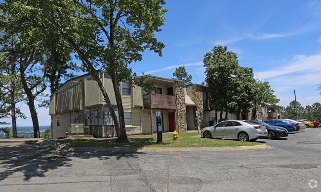
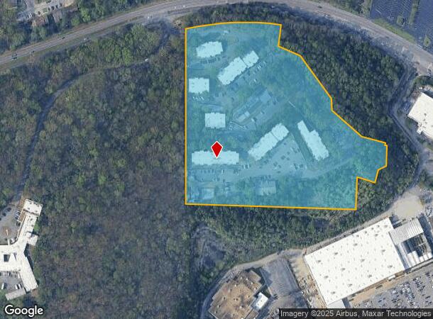
1036 Crestwood Blvd
Birmingham-Hoover, AL
Crestwood Man Re 23-27-1
23-00-27-1-002-003.001
POB SW COR OF LOT 3-A CRESTWOOD MANOR RESUR OF LOT 3 ALSO BEING SW COR OF NW 1/4 OF NE 1/4 TH N 880 FT TH ELY 390 FT TH S 102.9 FT TH SE 110.7 FT TH SE 243 FT TH SE 54.4 FT TH SE 181.8 FT TH SE 113 FT TH S 10 FT TH E 7 FT TH S 95 FT TH SW 41 FT TH SW
Apartment
Jefferson
X
Alabama
01073C0413H
3-a,3
2023
12.60 AC
2024
Oak Ridge Park
000300
Birmingham
122,098 SF
DEMOGRAPHICS near 1036 Crestwood Blvd
1 Mile
3 Mile
5 Mile
2024 Total Population
8,352
56,227
130,587
2029 Population
8,249
55,578
129,375
Pop Growth 2024-2029
(1.23%)
(1.15%)
(0.93%)
Average Age
38
39
39
2024 Total Households
3,799
23,777
55,621
HH Growth 2024-2029
(1.50%)
(1.34%)
(0.90%)
Median Household Inc
$53,569
$55,357
$54,988
Avg Household Size
2.00
2.20
2.10
2024 Avg HH Vehicles
1.00
2.00
2.00
Median Home Value
$251,926
$274,286
$287,485
Median Year Built
1964
1964
1966
Nearby Places
Map Layers
Map Styles
 Street
 Aerial
- Restaurants
- Banks
- Shops
- Fitness
- Groceries
PUBLIC TRANSPORTATION
COMMUTER RAIL
Birmingham (Crescent - Amtrak)
DRIVE
WALK
Distance
Birmingham (Crescent - Amtrak)
9 min
5.1 mi
AIRPORT
Birmingham-Shuttlesworth International
DRIVE
WALK
Distance
Birmingham-Shuttlesworth International
9 min
4.2 mi
Freight Ports
Port of Mobile
DRIVE
WALK
Distance
Port of Mobile
287 min
260.4 mi
Nearby Properties
Address
Land Use
TOTAL SIZE
Lot Size
Zoning
Address
Land Use
TOTAL SIZE
Lot Size
Zoning
145,865 SF
142 AC
M1-M
Address
Land Use
TOTAL SIZE
Lot Size
Zoning
298,966 SF
73 AC
M1
Address
Land Use
TOTAL SIZE
Lot Size
Zoning
166,863 SF
21 AC
CB2
Address
Land Use
TOTAL SIZE
Lot Size
Zoning
80,288 SF
2.91 AC
CB2
Address
Land Use
TOTAL SIZE
Lot Size
Zoning
155,160 SF
14.20 AC
B6
Address
Land Use
TOTAL SIZE
Lot Size
Zoning
423,995 SF
25 AC
R3
Address
Land Use
TOTAL SIZE
Lot Size
Zoning
144,135 SF
31.95 AC
CR5
Address
Land Use
TOTAL SIZE
Lot Size
Zoning
Address
Land Use
TOTAL SIZE
Lot Size
Zoning
297,391 SF
27.10 AC
CR5
Address
Land Use
TOTAL SIZE
Lot Size
Zoning
345,035 SF
39 AC
M1
Address
Land Use
TOTAL SIZE
Lot Size
Zoning
50,794 SF
2.02 AC
R6
Address
Land Use
TOTAL SIZE
Lot Size
Zoning
50,794 SF
1.62 AC
R6
Address
Land Use
TOTAL SIZE
Lot Size
Zoning
131,319 SF
13.28 AC
CB2
Address
Land Use
TOTAL SIZE
Lot Size
Zoning
235,552 SF
10.13 AC
R3
Address
Land Use
TOTAL SIZE
Lot Size
Zoning
83,931 SF
5.90 AC
O&I
Address
Land Use
TOTAL SIZE
Lot Size
Zoning
456,619 SF
27.30 AC
M2
Address
Land Use
TOTAL SIZE
Lot Size
Zoning
52,407 SF
25.71 AC
R2
Address
Land Use
TOTAL SIZE
Lot Size
Zoning
74,154 SF
4.20 AC
R-A
Address
Land Use
TOTAL SIZE
Lot Size
Zoning
83,776 SF
3.79 AC
B6
Address
Land Use
TOTAL SIZE
Lot Size
Zoning
22 AC
CB2
Address
Land Use
TOTAL SIZE
Lot Size
Zoning
127,131 SF
22.40 AC
QR7
Address
Land Use
TOTAL SIZE
Lot Size
Zoning
210,920 SF
22.41 AC
CB2
Address
Land Use
TOTAL SIZE
Lot Size
Zoning
145,949 SF
10.01 AC
QR6
Address
Land Use
TOTAL SIZE
Lot Size
Zoning
222,082 SF
46 AC
R3
Address
Land Use
TOTAL SIZE
Lot Size
Zoning
102,748 SF
8.50 AC
CB2
Address
Land Use
TOTAL SIZE
Lot Size
Zoning
113,147 SF
115 AC
M1
Address
Land Use
TOTAL SIZE
Lot Size
Zoning
8.10 AC
QR6
Address
Land Use
TOTAL SIZE
Lot Size
Zoning
223,365 SF
15 AC
I1
Address
Land Use
TOTAL SIZE
Lot Size
Zoning
108,813 SF
156 AC
M-1
Address
Land Use
TOTAL SIZE
Lot Size
Zoning
29,095 SF
2.64 AC
B2
The World's #1 Commercial Real Estate Marketplace
Connect with us
© 2026 CoStar Group
The information above has been obtained from sources believed reliable. While we do not doubt its accuracy we have not verified it and make no guarantee, warranty or representation about it. It is your responsibility to independently confirm its accuracy and completeness. Any projections, opinions, assumptions, or estimates used are for example only and do not represent the current or future performance of the property. The value of this transaction to you depends on tax and other factors which should be evaluated by your tax, financial, and legal advisors. You and your advisors should conduct a careful, independent investigation of the property to determine to your satisfaction the suitability of the property for your needs.