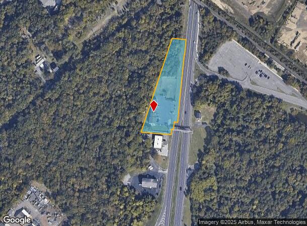
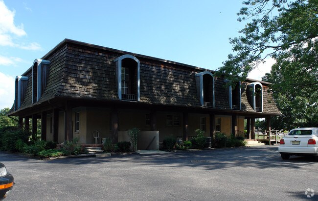
Property Record
1036 S Route 73, Berlin, NJ 08009

NEARBY LISTINGS FOR SALE OR LEASE
Property Detail
1036 S Route 73
Philadelphia-Camden-Wilmington, PA-NJ-DE-MD
FACILITY NAME: RED CARPET INN
05-01601-0000-00013
Camden
Commercialnec
New Jersey
X
13
34005C0366F
1.83 AC
2024
South Camden County
2025
Philadelphia
608700
DEMOGRAPHICS near 1036 S Route 73
1 Mile
3 Mile
5 Mile
2024 Total Population
4,399
31,992
88,482
2029 Population
4,545
32,277
88,498
Pop Growth 2024-2029
+ 3.32%
+ 0.89%
+ 0.02%
Average Age
42
42
41
2024 Total Households
1,800
12,102
33,318
HH Growth 2024-2029
+ 3.56%
+ 1.00%
+ 0.07%
Median Household Inc
$102,996
$102,164
$85,392
Avg Household Size
2.40
2.60
2.60
2024 Avg HH Vehicles
2.00
2.00
2.00
Median Home Value
$244,782
$275,620
$265,928
Median Year Built
1982
1978
1978
Nearby Places
Map Layers
Map Styles
 Street
 Aerial
- Restaurants
- Banks
- Shops
- Fitness
- Groceries
PUBLIC TRANSPORTATION
TRANSIT/SUBWAY
Atco (Atlantic City Line - NJ Transit Commuter Rail (NJ Transit))
DRIVE
WALK
Distance
Atco (Atlantic City Line - NJ Transit Commuter Rail (NJ Transit))
3 min
2 min
0.1 mi
COMMUTER RAIL
Atco (Atlantic City Line - NJ Transit Commuter Rail (NJ Transit))
DRIVE
WALK
Distance
Atco (Atlantic City Line - NJ Transit Commuter Rail (NJ Transit))
3 min
2 min
0.1 mi
Lindenwold (NJT) (Atlantic City Line - NJ Transit Commuter Rail (NJ Transit))
DRIVE
WALK
Distance
Lindenwold (NJT) (Atlantic City Line - NJ Transit Commuter Rail (NJ Transit))
10 min
6.7 mi
AIRPORT
Philadelphia International
DRIVE
WALK
Distance
Philadelphia International
39 min
25.4 mi
Atlantic City International
DRIVE
WALK
Distance
Atlantic City International
62 min
33.1 mi
Trenton Mercer
DRIVE
WALK
Distance
Trenton Mercer
64 min
45.4 mi
Freight Ports
Broadway Terminal - Pier 5
DRIVE
WALK
Distance
Broadway Terminal - Pier 5
24 min
16.9 mi
Nearby Properties
Address
Land Use
TOTAL SIZE
Lot Size
Zoning
Address
Land Use
TOTAL SIZE
Lot Size
Zoning
6,208 SF
30.73 AC
PARC
Address
Land Use
TOTAL SIZE
Lot Size
Zoning
137.33 AC
PR3
Address
Land Use
TOTAL SIZE
Lot Size
Zoning
44.34 AC
C1
Address
Land Use
TOTAL SIZE
Lot Size
Zoning
88.36 AC
PR4
Address
Land Use
TOTAL SIZE
Lot Size
Zoning
73.95 AC
PI3
Address
Land Use
TOTAL SIZE
Lot Size
Zoning
27.18 AC
PR4
Address
Land Use
TOTAL SIZE
Lot Size
Zoning
14.53 AC
C2
Address
Land Use
TOTAL SIZE
Lot Size
Zoning
4.67 AC
INST
Address
Land Use
TOTAL SIZE
Lot Size
Zoning
155 AC
PI
Address
Land Use
TOTAL SIZE
Lot Size
Zoning
34.55 AC
INS
Address
Land Use
TOTAL SIZE
Lot Size
Zoning
19.46 AC
INST
Address
Land Use
TOTAL SIZE
Lot Size
Zoning
69,324 SF
20.26 AC
Address
Land Use
TOTAL SIZE
Lot Size
Zoning
59,361 SF
19.21 AC
INST
Address
Land Use
TOTAL SIZE
Lot Size
Zoning
5,739 SF
11.75 AC
C2
Address
Land Use
TOTAL SIZE
Lot Size
Zoning
22.93 AC
PC-2
Address
Land Use
TOTAL SIZE
Lot Size
Zoning
14.10 AC
RD-1
Address
Land Use
TOTAL SIZE
Lot Size
Zoning
2,098 SF
27 AC
C-2
Address
Land Use
TOTAL SIZE
Lot Size
Zoning
8.16 AC
I1
Address
Land Use
TOTAL SIZE
Lot Size
Zoning
8.56 AC
PARC
Address
Land Use
TOTAL SIZE
Lot Size
Zoning
14.42 AC
MB
Address
Land Use
TOTAL SIZE
Lot Size
Zoning
0.42 AC
E-1
Address
Land Use
TOTAL SIZE
Lot Size
Zoning
6.21 AC
R3
Address
Land Use
TOTAL SIZE
Lot Size
Zoning
26,184 SF
3.77 AC
C-2
Address
Land Use
TOTAL SIZE
Lot Size
Zoning
15,950 SF
12.73 AC
C
Address
Land Use
TOTAL SIZE
Lot Size
Zoning
29,300 SF
3.36 AC
C2
Address
Land Use
TOTAL SIZE
Lot Size
Zoning
5,092 SF
7 AC
C2
Address
Land Use
TOTAL SIZE
Lot Size
Zoning
3.61 AC
C1
Address
Land Use
TOTAL SIZE
Lot Size
Zoning
5.06 AC
PF
Address
Land Use
TOTAL SIZE
Lot Size
Zoning
15.84 AC
RPF
Address
Land Use
TOTAL SIZE
Lot Size
Zoning
7.07 AC
PF
The World's #1 Commercial Real Estate Marketplace
Connect with us
© 2026 CoStar Group
The information above has been obtained from sources believed reliable. While we do not doubt its accuracy we have not verified it and make no guarantee, warranty or representation about it. It is your responsibility to independently confirm its accuracy and completeness. Any projections, opinions, assumptions, or estimates used are for example only and do not represent the current or future performance of the property. The value of this transaction to you depends on tax and other factors which should be evaluated by your tax, financial, and legal advisors. You and your advisors should conduct a careful, independent investigation of the property to determine to your satisfaction the suitability of the property for your needs.