Property Record
1036 Sprenkle Rd, Spring Grove, PA 17362
This Property Is For Sale
NEARBY LISTINGS FOR SALE OR LEASE
Property Detail
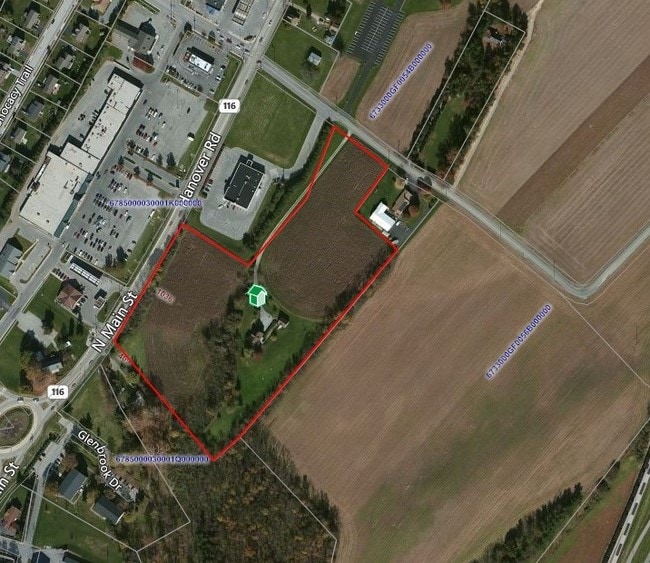
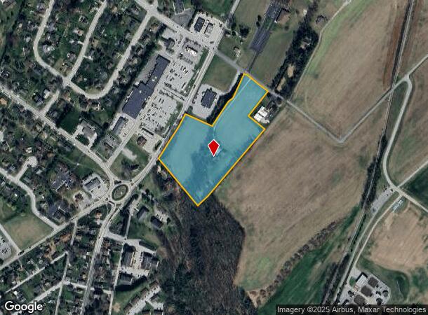
1036 Sprenkle Rd
33-000-GF-0062.C0-00000
Weacer Plan Of Lots
Cropfieldcropsrowcropsallsoilclasses
LOT 2; PP OO-850
X
York
42133C0313F
Pennsylvania
2025
10.68 AC
2025
York County
020524
Philadelphia
2,705 SF
York-Hanover, PA
DEMOGRAPHICS near 1036 Sprenkle Rd
1 mile
3 mile
5 mile
2024 Total Population
3,378
12,038
27,082
2029 Population
3,493
12,364
27,615
Pop Growth 2024-2029
+ 3.40%
+ 2.71%
+ 1.97%
Average Age
40
42
42
2024 Total Households
1,366
4,670
10,545
HH Growth 2024-2029
+ 3.44%
+ 2.72%
+ 2.00%
Median Household Inc
$70,081
$75,492
$78,260
Avg Household Size
2.50
2.50
2.50
2024 Avg HH Vehicles
2.00
2.00
2.00
Median Home Value
$195,160
$226,542
$228,535
Median Year Built
1974
1982
1977
Nearby Places
Map Layers
Map Styles
 Street
 Aerial
Transit
 Traffic
 Biking
Places
Listings with unknown addresses are not visible on the map
- Restaurants
- Banks
- Shops
- Fitness
- Groceries
PUBLIC TRANSPORTATION
AIRPORT
Harrisburg International
Drive
Walk
Distance
Harrisburg International
57 min
38.7 mi
Freight Ports
Port of Baltimore
Drive
Walk
Distance
Port of Baltimore
87 min
53.2 mi
Nearby Properties
Address
Land Use
TOTAL SIZE
Lot Size
Zoning
Address
Land Use
TOTAL SIZE
Lot Size
Zoning
22,100 SF
138.33 AC
ID
Address
Land Use
TOTAL SIZE
Lot Size
Zoning
10,684 SF
57.59 AC
AG
Address
Land Use
TOTAL SIZE
Lot Size
Zoning
252,000 SF
50.45 AC
I
Address
Land Use
TOTAL SIZE
Lot Size
Zoning
62,707 SF
8.70 AC
CM
Address
Land Use
TOTAL SIZE
Lot Size
Zoning
2,814 SF
116.97 AC
ID
Address
Land Use
TOTAL SIZE
Lot Size
Zoning
28,372 SF
5.15 AC
C
Address
Land Use
TOTAL SIZE
Lot Size
Zoning
1,924 SF
33.09 AC
AG
Address
Land Use
TOTAL SIZE
Lot Size
Zoning
50,094 SF
5.69 AC
RS
Address
Land Use
TOTAL SIZE
Lot Size
Zoning
2,484 SF
70 AC
MU
Address
Land Use
TOTAL SIZE
Lot Size
Zoning
14,004 SF
4.15 AC
RS
Address
Land Use
TOTAL SIZE
Lot Size
Zoning
4,992 SF
212 AC
ID
Address
Land Use
TOTAL SIZE
Lot Size
Zoning
1,440 SF
10 AC
Address
Land Use
TOTAL SIZE
Lot Size
Zoning
43,308 SF
40.34 AC
RS
Address
Land Use
TOTAL SIZE
Lot Size
Zoning
22,995 SF
1.51 AC
TR
Address
Land Use
TOTAL SIZE
Lot Size
Zoning
80,728 SF
6.28 AC
RS
Address
Land Use
TOTAL SIZE
Lot Size
Zoning
93.86 AC
Address
Land Use
TOTAL SIZE
Lot Size
Zoning
3,745 SF
149.39 AC
AG
Address
Land Use
TOTAL SIZE
Lot Size
Zoning
10.70 AC
CM
Address
Land Use
TOTAL SIZE
Lot Size
Zoning
1,672 SF
5.11 AC
I
Address
Land Use
TOTAL SIZE
Lot Size
Zoning
61,012 SF
3.02 AC
ID
Address
Land Use
TOTAL SIZE
Lot Size
Zoning
29,840 SF
125.52 AC
CM
Address
Land Use
TOTAL SIZE
Lot Size
Zoning
11,301 SF
3.39 AC
C
Address
Land Use
TOTAL SIZE
Lot Size
Zoning
12,486 SF
3.33 AC
TR
Address
Land Use
TOTAL SIZE
Lot Size
Zoning
6,400 SF
106 AC
RAC
Address
Land Use
TOTAL SIZE
Lot Size
Zoning
14,552 SF
1.46 AC
RS
Address
Land Use
TOTAL SIZE
Lot Size
Zoning
3,942 SF
1.42 AC
CM
Address
Land Use
TOTAL SIZE
Lot Size
Zoning
6,467 SF
86.54 AC
MU
Address
Land Use
TOTAL SIZE
Lot Size
Zoning
4,861 SF
2.85 AC
R1
Address
Land Use
TOTAL SIZE
Lot Size
Zoning
94.50 AC
ID
Address
Land Use
TOTAL SIZE
Lot Size
Zoning
13,942 SF
1.22 AC
RS
The World's #1 Commercial Real Estate Marketplace
Connect with us
© 2026 CoStar Group
The information above has been obtained from sources believed reliable. While we do not doubt its accuracy we have not verified it and make no guarantee, warranty or representation about it. It is your responsibility to independently confirm its accuracy and completeness. Any projections, opinions, assumptions, or estimates used are for example only and do not represent the current or future performance of the property. The value of this transaction to you depends on tax and other factors which should be evaluated by your tax, financial, and legal advisors. You and your advisors should conduct a careful, independent investigation of the property to determine to your satisfaction the suitability of the property for your needs.