Property Record
1037 E Bobier Dr, Vista, CA 92084
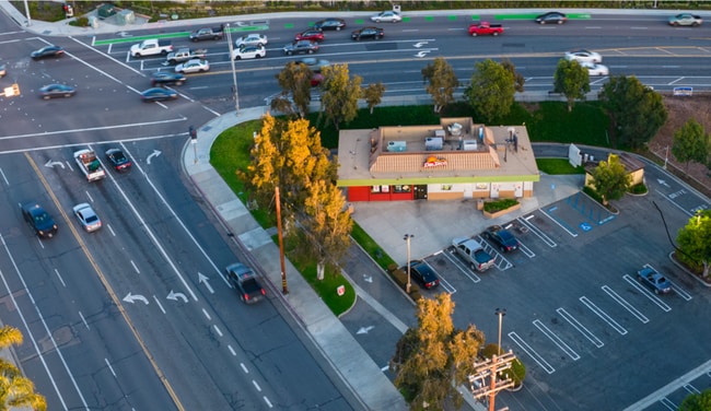


Property Detail
1037 E Bobier Dr
173-250-40
PAR A (EX STS) TR PM11215
Publicstorage
San Diego
C-1
California
C and X Area of minimal flood hazard, usually depicted on FIRMs as above the 500-year flood level.
0.72 AC
2024
Vista
2025
San Diego
019206
San Diego-Chula Vista-Carlsbad, CA
1,959 SF
NEARBY LISTINGS FOR SALE OR LEASE
DEMOGRAPHICS near 1037 E Bobier Dr
1 mile
3 mile
5 mile
2025 Total Population
21,970
96,691
211,593
2030 Population
22,181
97,221
212,235
Pop Growth 2025-2030
+ 0.96%
+ 0.55%
+ 0.30%
Average Age
37
39
40
2025 Total Households
6,591
30,246
69,197
HH Growth 2025-2030
+ 0.80%
+ 0.37%
+ 0.15%
Median Household Inc
$84,642
$97,558
$104,471
Avg Household Size
3.20
3.00
2.90
2025 Avg HH Vehicles
2.00
2.00
2.00
Median Home Value
$675,000
$754,332
$769,211
Median Year Built
1977
1980
1984
Nearby Places
Map Layers
Map Styles
 Street
 Aerial
Transit
 Traffic
 Biking
Places
Listings with unknown addresses are not visible on the map
- Restaurants
- Banks
- Shops
- Fitness
- Groceries
PUBLIC TRANSPORTATION
COMMUTER RAIL
Carlsbad Village (Coaster - San Diego North County Transit District (Coaster/Sprinter/Breeze))
Drive
Walk
Distance
Carlsbad Village (Coaster - San Diego North County Transit District (Coaster/Sprinter/Breeze))
16 min
10.0 mi
Freight Ports
Port of San Diego
Drive
Walk
Distance
Port of San Diego
59 min
45.2 mi
SALE & LEASE HISTORY
LISTING DATE
SALE/LEASE

Mar 13, 2024
For Sale
Jun 26, 2023
For Sale
Jun 06, 2025
For Lease
Aug 11, 2025
For Lease
Nearby Properties
Address
Land Use
TOTAL SIZE
Lot Size
Zoning
Address
Land Use
TOTAL SIZE
Lot Size
Zoning
20.10 AC
M-U
Address
Land Use
TOTAL SIZE
Lot Size
Zoning
10.39 AC
M-U (40)
Address
Land Use
TOTAL SIZE
Lot Size
Zoning
11.17 AC
M-U
Address
Land Use
TOTAL SIZE
Lot Size
Zoning
21.44 AC
C-1
Address
Land Use
TOTAL SIZE
Lot Size
Zoning
1.23 AC
SPI
Address
Land Use
TOTAL SIZE
Lot Size
Zoning
7.97 AC
SPI-DV
Address
Land Use
TOTAL SIZE
Lot Size
Zoning
9.48 AC
R-M
Address
Land Use
TOTAL SIZE
Lot Size
Zoning
14.08 AC
RH
Address
Land Use
TOTAL SIZE
Lot Size
Zoning
8.67 AC
R-M
Address
Land Use
TOTAL SIZE
Lot Size
Zoning
10.38 AC
R-M
Address
Land Use
TOTAL SIZE
Lot Size
Zoning
6.55 AC
R-M
Address
Land Use
TOTAL SIZE
Lot Size
Zoning
3.32 AC
SPI
Address
Land Use
TOTAL SIZE
Lot Size
Zoning
10.59 AC
RH
Address
Land Use
TOTAL SIZE
Lot Size
Zoning
3.99 AC
M-U
Address
Land Use
TOTAL SIZE
Lot Size
Zoning
4.34 AC
SP-08
Address
Land Use
TOTAL SIZE
Lot Size
Zoning
74,866 SF
3.18 AC
C-1
Address
Land Use
TOTAL SIZE
Lot Size
Zoning
7.18 AC
R-M
Address
Land Use
TOTAL SIZE
Lot Size
Zoning
99,906 SF
5.06 AC
R-M
Address
Land Use
TOTAL SIZE
Lot Size
Zoning
14.67 AC
R-M
Address
Land Use
TOTAL SIZE
Lot Size
Zoning
59,481 SF
2.63 AC
C-1
Address
Land Use
TOTAL SIZE
Lot Size
Zoning
77,084 SF
2.12 AC
SPI
Address
Land Use
TOTAL SIZE
Lot Size
Zoning
3.30 AC
M-U
Address
Land Use
TOTAL SIZE
Lot Size
Zoning
6.53 AC
R-M
Address
Land Use
TOTAL SIZE
Lot Size
Zoning
89,926 SF
4.25 AC
C-1
Address
Land Use
TOTAL SIZE
Lot Size
Zoning
43,610 SF
10.57 AC
SPI
Address
Land Use
TOTAL SIZE
Lot Size
Zoning
56,500 SF
5.02 AC
R-1
Address
Land Use
TOTAL SIZE
Lot Size
Zoning
10.25 AC
C-1
Address
Land Use
TOTAL SIZE
Lot Size
Zoning
4.03 AC
70
Address
Land Use
TOTAL SIZE
Lot Size
Zoning
7.82 AC
IL-MP-3-82
Address
Land Use
TOTAL SIZE
Lot Size
Zoning
88,361 SF
4.94 AC
IL
The World's #1 Commercial Real Estate Marketplace
Connect with us
© 2026 CoStar Group
The information above has been obtained from sources believed reliable. While we do not doubt its accuracy we have not verified it and make no guarantee, warranty or representation about it. It is your responsibility to independently confirm its accuracy and completeness. Any projections, opinions, assumptions, or estimates used are for example only and do not represent the current or future performance of the property. The value of this transaction to you depends on tax and other factors which should be evaluated by your tax, financial, and legal advisors. You and your advisors should conduct a careful, independent investigation of the property to determine to your satisfaction the suitability of the property for your needs.