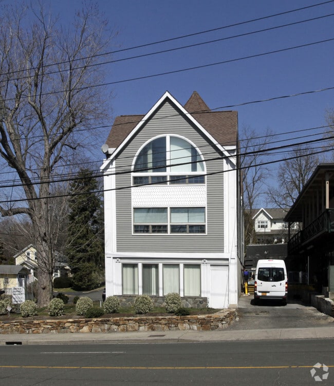
Property Record
1037 E Putnam Ave, Riverside, CT 06878


Current Lease Availabilities
Property Detail
1037 E Putnam Ave
Commercialofficeresidentialmixeduse
Western Ct
LBR-2
Connecticut
B and X Area of moderate flood hazard, usually the area between the limits of the 100-year and 500-year floods.
0.26 AC
2025
Greenwich
2025
Westchester/So Connecticut
010900
Bridgeport-Stamford-Danbury, CT
6,796 SF
GREE-000012-000000-001001-S000000
NEARBY LISTINGS FOR SALE OR LEASE
DEMOGRAPHICS near 1037 E Putnam Ave
1 mile
3 mile
5 mile
2025 Total Population
12,570
94,778
200,142
2030 Population
12,821
97,534
204,205
Pop Growth 2025-2030
+ 2.00%
+ 2.91%
+ 2.03%
Average Age
41
40
40
2025 Total Households
4,445
38,162
77,149
HH Growth 2025-2030
+ 1.84%
+ 3.28%
+ 2.24%
Median Household Inc
$204,917
$116,542
$117,105
Avg Household Size
2.80
2.40
2.50
2025 Avg HH Vehicles
2.00
2.00
2.00
Median Home Value
$1,077,173
$1,026,312
$849,932
Median Year Built
1961
1979
1968
Nearby Places
Map Layers
Map Styles
 Street
 Aerial
Transit
 Traffic
 Biking
Places
Listings with unknown addresses are not visible on the map
- Restaurants
- Banks
- Shops
- Fitness
- Groceries
PUBLIC TRANSPORTATION
COMMUTER RAIL
Riverside Station (New Haven Line - Metro-North Commuter Railroad Company (Metro-North))
Drive
Walk
Distance
Riverside Station (New Haven Line - Metro-North Commuter Railroad Company (Metro-North))
2 min
16 min
0.8 mi
Cos Cob Station (New Haven Line - Metro-North Commuter Railroad Company (Metro-North))
Drive
Walk
Distance
Cos Cob Station (New Haven Line - Metro-North Commuter Railroad Company (Metro-North))
3 min
1.5 mi
AIRPORT
Westchester County
Drive
Walk
Distance
Westchester County
18 min
9.7 mi
LaGuardia
Drive
Walk
Distance
LaGuardia
46 min
29.6 mi
John F Kennedy International
Drive
Walk
Distance
John F Kennedy International
52 min
37.1 mi
Freight Ports
NY - Red Hook Container Terminal
Drive
Walk
Distance
NY - Red Hook Container Terminal
61 min
40.1 mi
Nearby Properties
Address
Land Use
TOTAL SIZE
Lot Size
Zoning
Address
Land Use
TOTAL SIZE
Lot Size
Zoning
244,937 SF
4.20 AC
WB
Address
Land Use
TOTAL SIZE
Lot Size
Zoning
13.21 AC
CSCD
Address
Land Use
TOTAL SIZE
Lot Size
Zoning
4,179 SF
3.32 AC
GBO
Address
Land Use
TOTAL SIZE
Lot Size
Zoning
5.10 AC
MXD
Address
Land Use
TOTAL SIZE
Lot Size
Zoning
7,791 SF
33.47 AC
RA-1
Address
Land Use
TOTAL SIZE
Lot Size
Zoning
175,339 SF
2.12 AC
CGB
Address
Land Use
TOTAL SIZE
Lot Size
Zoning
57,033 SF
33.04 AC
RA-1
Address
Land Use
TOTAL SIZE
Lot Size
Zoning
397,378 SF
4.25 AC
CC
Address
Land Use
TOTAL SIZE
Lot Size
Zoning
543,005 SF
2.23 AC
RHD
Address
Land Use
TOTAL SIZE
Lot Size
Zoning
411,596 SF
3.30 AC
MZN
Address
Land Use
TOTAL SIZE
Lot Size
Zoning
4.13 AC
CC
Address
Land Use
TOTAL SIZE
Lot Size
Zoning
Address
Land Use
TOTAL SIZE
Lot Size
Zoning
17.54 AC
DWD
Address
Land Use
TOTAL SIZE
Lot Size
Zoning
359,686 SF
1.67 AC
CCN
Address
Land Use
TOTAL SIZE
Lot Size
Zoning
377,754 SF
2.06 AC
PD
Address
Land Use
TOTAL SIZE
Lot Size
Zoning
78,159 SF
4.17 AC
CGB
Address
Land Use
TOTAL SIZE
Lot Size
Zoning
192,254 SF
1.15 AC
GBO
Address
Land Use
TOTAL SIZE
Lot Size
Zoning
8.21 AC
CWD
Address
Land Use
TOTAL SIZE
Lot Size
Zoning
9.56 AC
R-6
Address
Land Use
TOTAL SIZE
Lot Size
Zoning
98,106 SF
42.71 AC
RA-2
Address
Land Use
TOTAL SIZE
Lot Size
Zoning
304,617 SF
CI
Address
Land Use
TOTAL SIZE
Lot Size
Zoning
74,446 SF
10.39 AC
R-MF
Address
Land Use
TOTAL SIZE
Lot Size
Zoning
121,807 SF
16.08 AC
R-12
Address
Land Use
TOTAL SIZE
Lot Size
Zoning
377,918 SF
22.42 AC
MZN
Address
Land Use
TOTAL SIZE
Lot Size
Zoning
304,345 SF
1.15 AC
PD
Address
Land Use
TOTAL SIZE
Lot Size
Zoning
277,740 SF
2.82 AC
TCDD
Address
Land Use
TOTAL SIZE
Lot Size
Zoning
308,621 SF
CI
Address
Land Use
TOTAL SIZE
Lot Size
Zoning
93,514 SF
5 AC
CGB
Address
Land Use
TOTAL SIZE
Lot Size
Zoning
235,186 SF
1.29 AC
CG
Address
Land Use
TOTAL SIZE
Lot Size
Zoning
1.95 AC
SRDS
The World's #1 Commercial Real Estate Marketplace
Connect with us
© 2026 CoStar Group
The information above has been obtained from sources believed reliable. While we do not doubt its accuracy we have not verified it and make no guarantee, warranty or representation about it. It is your responsibility to independently confirm its accuracy and completeness. Any projections, opinions, assumptions, or estimates used are for example only and do not represent the current or future performance of the property. The value of this transaction to you depends on tax and other factors which should be evaluated by your tax, financial, and legal advisors. You and your advisors should conduct a careful, independent investigation of the property to determine to your satisfaction the suitability of the property for your needs.