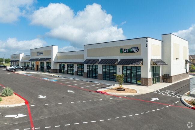
Property Record
1037 State Highway 46 S, New Braunfels, TX 78130
NEARBY LISTINGS FOR SALE OR LEASE
Property Detail
1037 State Highway 46 S
San Antonio-New Braunfels, TX
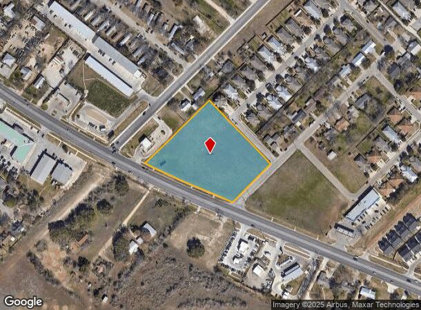
Oelkers Acres 2
40-0565-0095-00
OELKERS ACRES 2, LOT 1
Commercialnec
Comal
X
Texas
48091C0455G
1
2024
3.45 AC
2025
Comal County
310502
San Antonio
23,702 SF
DEMOGRAPHICS near 1037 State Highway 46 S
1 Mile
3 Mile
5 Mile
2024 Total Population
6,752
60,389
112,471
2029 Population
9,087
78,761
147,516
Pop Growth 2024-2029
+ 34.58%
+ 30.42%
+ 31.16%
Average Age
34
37
38
2024 Total Households
2,386
22,974
42,313
HH Growth 2024-2029
+ 34.70%
+ 31.27%
+ 31.82%
Median Household Inc
$79,120
$83,269
$82,090
Avg Household Size
2.70
2.50
2.60
2024 Avg HH Vehicles
2.00
2.00
2.00
Median Home Value
$207,512
$257,240
$268,583
Median Year Built
2006
2003
2004
Nearby Places
Map Layers
Map Styles
 Street
 Aerial
- Restaurants
- Banks
- Shops
- Fitness
- Groceries
PUBLIC TRANSPORTATION
AIRPORT
San Antonio International
DRIVE
WALK
Distance
San Antonio International
36 min
28.7 mi
Nearby Properties
Address
Land Use
TOTAL SIZE
Lot Size
Zoning
Address
Land Use
TOTAL SIZE
Lot Size
Zoning
111.44 AC
Address
Land Use
TOTAL SIZE
Lot Size
Zoning
396,438 SF
55.62 AC
Address
Land Use
TOTAL SIZE
Lot Size
Zoning
458,447 SF
19 AC
Address
Land Use
TOTAL SIZE
Lot Size
Zoning
331,273 SF
14.02 AC
Address
Land Use
TOTAL SIZE
Lot Size
Zoning
203,147 SF
816 AC
Address
Land Use
TOTAL SIZE
Lot Size
Zoning
538,760 SF
21.01 AC
Address
Land Use
TOTAL SIZE
Lot Size
Zoning
292,822 SF
12.29 AC
Address
Land Use
TOTAL SIZE
Lot Size
Zoning
248,377 SF
23.66 AC
Address
Land Use
TOTAL SIZE
Lot Size
Zoning
352,688 SF
23.58 AC
Address
Land Use
TOTAL SIZE
Lot Size
Zoning
381,528 SF
82.50 AC
Address
Land Use
TOTAL SIZE
Lot Size
Zoning
314,265 SF
10.10 AC
Address
Land Use
TOTAL SIZE
Lot Size
Zoning
304,441 SF
17.46 AC
Address
Land Use
TOTAL SIZE
Lot Size
Zoning
261,155 SF
11.57 AC
Address
Land Use
TOTAL SIZE
Lot Size
Zoning
269,288 SF
16.32 AC
Address
Land Use
TOTAL SIZE
Lot Size
Zoning
Address
Land Use
TOTAL SIZE
Lot Size
Zoning
146,400 SF
17.36 AC
Address
Land Use
TOTAL SIZE
Lot Size
Zoning
257,960 SF
8.85 AC
Address
Land Use
TOTAL SIZE
Lot Size
Zoning
186,838 SF
14.53 AC
Address
Land Use
TOTAL SIZE
Lot Size
Zoning
145,856 SF
9.52 AC
Address
Land Use
TOTAL SIZE
Lot Size
Zoning
163,226 SF
29.14 AC
Address
Land Use
TOTAL SIZE
Lot Size
Zoning
152,240 SF
14.13 AC
Address
Land Use
TOTAL SIZE
Lot Size
Zoning
116,316 SF
12.21 AC
Address
Land Use
TOTAL SIZE
Lot Size
Zoning
170,019 SF
4.46 AC
Address
Land Use
TOTAL SIZE
Lot Size
Zoning
3,937 SF
87.21 AC
Address
Land Use
TOTAL SIZE
Lot Size
Zoning
179,869 SF
10 AC
Address
Land Use
TOTAL SIZE
Lot Size
Zoning
266,325 SF
4.34 AC
Address
Land Use
TOTAL SIZE
Lot Size
Zoning
96,092 SF
52.22 AC
Address
Land Use
TOTAL SIZE
Lot Size
Zoning
180,795 SF
8.29 AC
Address
Land Use
TOTAL SIZE
Lot Size
Zoning
198,793 SF
9.38 AC
Address
Land Use
TOTAL SIZE
Lot Size
Zoning
49,770 SF
15.14 AC
The World's #1 Commercial Real Estate Marketplace
Connect with us
© 2026 CoStar Group
The information above has been obtained from sources believed reliable. While we do not doubt its accuracy we have not verified it and make no guarantee, warranty or representation about it. It is your responsibility to independently confirm its accuracy and completeness. Any projections, opinions, assumptions, or estimates used are for example only and do not represent the current or future performance of the property. The value of this transaction to you depends on tax and other factors which should be evaluated by your tax, financial, and legal advisors. You and your advisors should conduct a careful, independent investigation of the property to determine to your satisfaction the suitability of the property for your needs.