Property Record
10370 Haligus Rd, Huntley, IL 60142


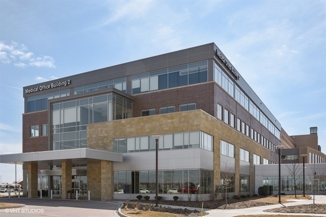
Property Detail
10370 Haligus Rd
Chicago-Naperville-Elgin, IL-IN
DOC 2014R0041747 (PLAT) PT LT A CENTEGRA HEALTH CARECAMPUS CONSOLIDATION MEMO: DIVISION PER OWNERS REQUEST
18-27-201-006
McHenry
Commercialnec
Illinois
B and X Area of moderate flood hazard, usually the area between the limits of the 100-year and 500-year floods.
a
2024
3.50 AC
2024
Far Northwest
871114
Chicago
NEARBY LISTINGS FOR SALE OR LEASE
DEMOGRAPHICS near 10370 Haligus Rd
1 mile
3 mile
5 mile
2025 Total Population
10,825
53,022
113,547
2030 Population
10,938
53,883
115,097
Pop Growth 2025-2030
+ 1.04%
+ 1.62%
+ 1.37%
Average Age
36
39
42
2025 Total Households
3,192
17,348
41,165
HH Growth 2025-2030
+ 1.10%
+ 1.74%
+ 1.40%
Median Household Inc
$141,120
$129,373
$109,157
Avg Household Size
3.30
3.00
2.70
2025 Avg HH Vehicles
2.00
2.00
2.00
Median Home Value
$343,045
$363,957
$337,322
Median Year Built
1999
2000
1996
Nearby Places
Map Layers
Map Styles
 Street
 Aerial
Layers
 Traffic
 Biking
Places
Listings with unknown addresses are not visible on the map
- Restaurants
- Banks
- Shops
- Fitness
- Groceries
PUBLIC TRANSPORTATION
COMMUTER RAIL
Crystal Lake Station (Union Pacific Northwest Line - Northeast Illinois Regional Commuter Railroad (Metra))
Drive
Walk
Distance
Crystal Lake Station (Union Pacific Northwest Line - Northeast Illinois Regional Commuter Railroad (Metra))
18 min
8.8 mi
Pingree Road Station (Union Pacific Northwest Line - Northeast Illinois Regional Commuter Railroad (Metra))
Drive
Walk
Distance
Pingree Road Station (Union Pacific Northwest Line - Northeast Illinois Regional Commuter Railroad (Metra))
19 min
9.0 mi
AIRPORT
Chicago O'Hare International
Drive
Walk
Distance
Chicago O'Hare International
51 min
37.4 mi
Freight Ports
Port Milwaukee
Drive
Walk
Distance
Port Milwaukee
113 min
78.6 mi
SALE & LEASE HISTORY
LISTING DATE
SALE/LEASE

Sep 25, 2016
For Lease
Mar 29, 2017
For Lease
Nearby Properties
Address
Land Use
TOTAL SIZE
Lot Size
Zoning
Address
Land Use
TOTAL SIZE
Lot Size
Zoning
7.26 AC
Address
Land Use
TOTAL SIZE
Lot Size
Zoning
11.86 AC
Address
Land Use
TOTAL SIZE
Lot Size
Zoning
189,735 SF
21.85 AC
Address
Land Use
TOTAL SIZE
Lot Size
Zoning
Address
Land Use
TOTAL SIZE
Lot Size
Zoning
Address
Land Use
TOTAL SIZE
Lot Size
Zoning
Address
Land Use
TOTAL SIZE
Lot Size
Zoning
0.71 AC
Address
Land Use
TOTAL SIZE
Lot Size
Zoning
9.28 AC
Address
Land Use
TOTAL SIZE
Lot Size
Zoning
8.23 AC
Address
Land Use
TOTAL SIZE
Lot Size
Zoning
57,813 SF
4.11 AC
Address
Land Use
TOTAL SIZE
Lot Size
Zoning
Address
Land Use
TOTAL SIZE
Lot Size
Zoning
92,850 SF
5 AC
Address
Land Use
TOTAL SIZE
Lot Size
Zoning
24,700 SF
3.08 AC
Address
Land Use
TOTAL SIZE
Lot Size
Zoning
3,144 SF
4.81 AC
Address
Land Use
TOTAL SIZE
Lot Size
Zoning
85,500 SF
7 AC
Address
Land Use
TOTAL SIZE
Lot Size
Zoning
2.55 AC
Address
Land Use
TOTAL SIZE
Lot Size
Zoning
5.40 AC
Address
Land Use
TOTAL SIZE
Lot Size
Zoning
Address
Land Use
TOTAL SIZE
Lot Size
Zoning
Address
Land Use
TOTAL SIZE
Lot Size
Zoning
14,606 SF
2.14 AC
Address
Land Use
TOTAL SIZE
Lot Size
Zoning
0.27 AC
Address
Land Use
TOTAL SIZE
Lot Size
Zoning
24,157 SF
1.97 AC
Address
Land Use
TOTAL SIZE
Lot Size
Zoning
71,064 SF
7 AC
Address
Land Use
TOTAL SIZE
Lot Size
Zoning
65,235 SF
4.74 AC
Address
Land Use
TOTAL SIZE
Lot Size
Zoning
48,150 SF
3.42 AC
Address
Land Use
TOTAL SIZE
Lot Size
Zoning
9,440 SF
1.68 AC
Address
Land Use
TOTAL SIZE
Lot Size
Zoning
Address
Land Use
TOTAL SIZE
Lot Size
Zoning
22,100 SF
3 AC
Address
Land Use
TOTAL SIZE
Lot Size
Zoning
71,331 SF
8 AC
The World's #1 Commercial Real Estate Marketplace
Connect with us
© 2026 CoStar Group
The information above has been obtained from sources believed reliable. While we do not doubt its accuracy we have not verified it and make no guarantee, warranty or representation about it. It is your responsibility to independently confirm its accuracy and completeness. Any projections, opinions, assumptions, or estimates used are for example only and do not represent the current or future performance of the property. The value of this transaction to you depends on tax and other factors which should be evaluated by your tax, financial, and legal advisors. You and your advisors should conduct a careful, independent investigation of the property to determine to your satisfaction the suitability of the property for your needs.