Property Record
1038 State Route 50, Ballston Lake, NY 12019
NEARBY LISTINGS FOR SALE OR LEASE
-
-
View all Ballston Lake listings for sale on LoopNet.com
Property Detail
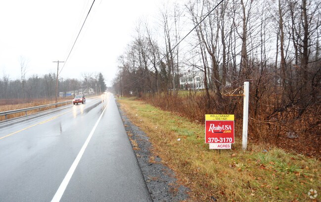
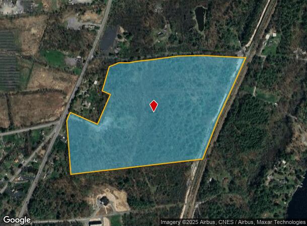
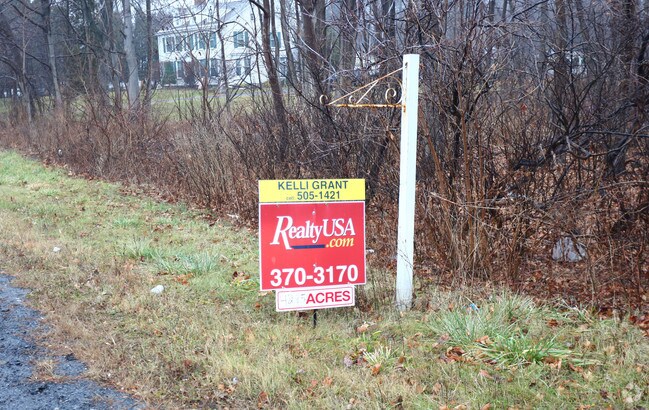
1038 State Route 50
Albany-Schenectady-Troy, NY
Saratoga
412089-239-000-0001-091-000-0000
New York
Agriculturalland
91.000
2025
42.85 AC
2024
Saratoga County
061702
Albany/Schenectady/Troy
DEMOGRAPHICS near 1038 State Route 50
1 Mile
3 Mile
5 Mile
2024 Total Population
761
14,196
45,191
2029 Population
800
14,850
46,936
Pop Growth 2024-2029
+ 5.12%
+ 4.61%
+ 3.86%
Average Age
42
42
43
2024 Total Households
294
5,857
18,692
HH Growth 2024-2029
+ 5.10%
+ 4.39%
+ 3.84%
Median Household Inc
$118,144
$95,387
$93,581
Avg Household Size
2.50
2.40
2.40
2024 Avg HH Vehicles
2.00
2.00
2.00
Median Home Value
$388,888
$374,999
$303,326
Median Year Built
2000
1993
1981
Nearby Places
- Restaurants
- Banks
- Shops
- Fitness
- Groceries
PUBLIC TRANSPORTATION
AIRPORT
Albany International
DRIVE
WALK
Distance
Albany International
31 min
22.4 mi
Freight Ports
Albany, NY Port
DRIVE
WALK
Distance
Albany, NY Port
47 min
32.9 mi
SALE & LEASE HISTORY
LISTING DATE
SALE/LEASE

Sep 24, 2016
For Sale
Nearby Properties
Address
Land Use
TOTAL SIZE
Lot Size
Zoning
Address
Land Use
TOTAL SIZE
Lot Size
Zoning
131,567 SF
47.50 AC
Address
Land Use
TOTAL SIZE
Lot Size
Zoning
7,000 SF
16.50 AC
PDD
Address
Land Use
TOTAL SIZE
Lot Size
Zoning
223,380 SF
58.20 AC
Address
Land Use
TOTAL SIZE
Lot Size
Zoning
5,400 SF
20.87 AC
PDD
Address
Land Use
TOTAL SIZE
Lot Size
Zoning
12,768 SF
22.12 AC
Address
Land Use
TOTAL SIZE
Lot Size
Zoning
74,400 SF
10.68 AC
PDD
Address
Land Use
TOTAL SIZE
Lot Size
Zoning
4,437 SF
9.18 AC
PDD
Address
Land Use
TOTAL SIZE
Lot Size
Zoning
4,437 SF
11.06 AC
PDD
Address
Land Use
TOTAL SIZE
Lot Size
Zoning
46,800 SF
9.70 AC
Address
Land Use
TOTAL SIZE
Lot Size
Zoning
7,000 SF
7.41 AC
PDD
Address
Land Use
TOTAL SIZE
Lot Size
Zoning
16,648 SF
7.17 AC
Address
Land Use
TOTAL SIZE
Lot Size
Zoning
57,616 SF
11 AC
PDD
Address
Land Use
TOTAL SIZE
Lot Size
Zoning
7,000 SF
5.87 AC
R1
Address
Land Use
TOTAL SIZE
Lot Size
Zoning
46,800 SF
5.63 AC
Address
Land Use
TOTAL SIZE
Lot Size
Zoning
71,473 SF
4 AC
Address
Land Use
TOTAL SIZE
Lot Size
Zoning
211,150 SF
23 AC
0
Address
Land Use
TOTAL SIZE
Lot Size
Zoning
33,000 SF
2.84 AC
Address
Land Use
TOTAL SIZE
Lot Size
Zoning
89,900 SF
22.03 AC
Address
Land Use
TOTAL SIZE
Lot Size
Zoning
5,100 SF
9.25 AC
PDD
Address
Land Use
TOTAL SIZE
Lot Size
Zoning
35,486 SF
11.40 AC
Address
Land Use
TOTAL SIZE
Lot Size
Zoning
4,437 SF
6.09 AC
PDD
Address
Land Use
TOTAL SIZE
Lot Size
Zoning
7,000 SF
4.25 AC
PDD
Address
Land Use
TOTAL SIZE
Lot Size
Zoning
8,974 SF
5.08 AC
Address
Land Use
TOTAL SIZE
Lot Size
Zoning
5,100 SF
5.72 AC
PDD
Address
Land Use
TOTAL SIZE
Lot Size
Zoning
7,000 SF
3.50 AC
PDD
Address
Land Use
TOTAL SIZE
Lot Size
Zoning
7,000 SF
4.06 AC
PDD
Address
Land Use
TOTAL SIZE
Lot Size
Zoning
31,840 SF
1.72 AC
Address
Land Use
TOTAL SIZE
Lot Size
Zoning
15,120 SF
5 AC
PDD
Address
Land Use
TOTAL SIZE
Lot Size
Zoning
22,032 SF
5.33 AC
Address
Land Use
TOTAL SIZE
Lot Size
Zoning
7,000 SF
3.28 AC
R1
The World's #1 Commercial Real Estate Marketplace
Connect with us
© 2025 CoStar Group
The information above has been obtained from sources believed reliable. While we do not doubt its accuracy we have not verified it and make no guarantee, warranty or representation about it. It is your responsibility to independently confirm its accuracy and completeness. Any projections, opinions, assumptions, or estimates used are for example only and do not represent the current or future performance of the property. The value of this transaction to you depends on tax and other factors which should be evaluated by your tax, financial, and legal advisors. You and your advisors should conduct a careful, independent investigation of the property to determine to your satisfaction the suitability of the property for your needs.