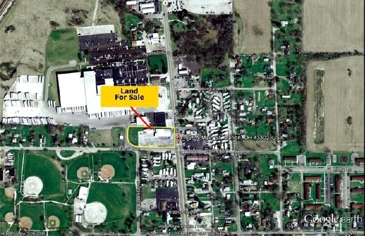
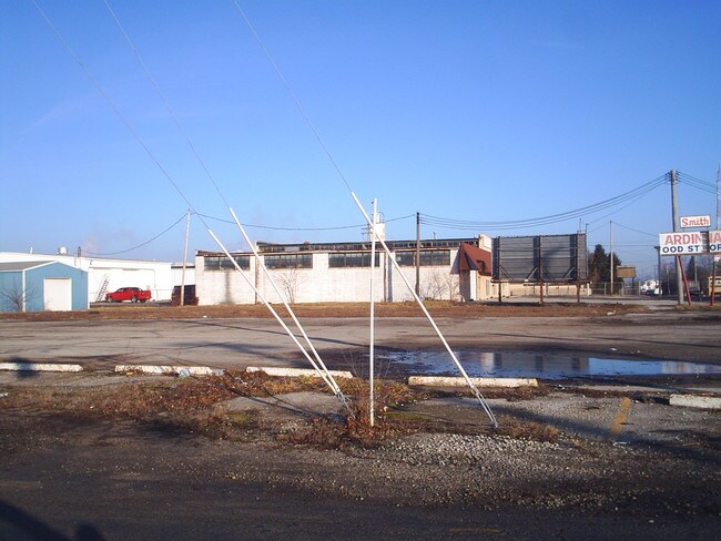
Property Record
1039 N Main St, Marion, OH 43302

Property Detail
1039 N Main St
Marion, OH
MARION LIME & STONE LOTS 1-3 PG 29 & LOTS 80-83 PG 2-29 & PT VAC ALLEY IRREG
16-0050100.200
MARION
Commercialnec
Ohio
B and X Area of moderate flood hazard, usually the area between the limits of the 100-year and 500-year floods.
1-3pg
2024
1 AC
2025
Ohio North Area
000502
Other Market Areas
NEARBY LISTINGS FOR SALE OR LEASE
-
-
View all Marion listings for sale on LoopNet.com
DEMOGRAPHICS near 1039 N Main St
1 mile
3 mile
5 mile
2025 Total Population
5,909
36,196
46,005
2030 Population
5,959
36,355
46,065
Pop Growth 2025-2030
+ 0.85%
+ 0.44%
+ 0.13%
Average Age
38
40
41
2025 Total Households
2,337
13,957
18,211
HH Growth 2025-2030
+ 0.77%
+ 0.47%
+ 0.13%
Median Household Inc
$40,540
$47,462
$51,498
Avg Household Size
2.40
2.30
2.30
2025 Avg HH Vehicles
2.00
2.00
2.00
Median Home Value
$81,302
$116,932
$138,060
Median Year Built
1958
1953
1959
Nearby Places
Map Layers
Map Styles
 Street
 Aerial
Layers
 Traffic
 Biking
Places
Listings with unknown addresses are not visible on the map
- Restaurants
- Banks
- Shops
- Fitness
- Groceries
SALE & LEASE HISTORY
LISTING DATE
SALE/LEASE

Sep 24, 2016
For Sale
Nearby Properties
Address
Land Use
TOTAL SIZE
Lot Size
Zoning
Address
Land Use
TOTAL SIZE
Lot Size
Zoning
881,106 SF
225.79 AC
Address
Land Use
TOTAL SIZE
Lot Size
Zoning
304,391 SF
19.05 AC
Address
Land Use
TOTAL SIZE
Lot Size
Zoning
356,764 SF
143.16 AC
Address
Land Use
TOTAL SIZE
Lot Size
Zoning
264,549 SF
107.63 AC
Address
Land Use
TOTAL SIZE
Lot Size
Zoning
135,911 SF
19.60 AC
Address
Land Use
TOTAL SIZE
Lot Size
Zoning
232,864 SF
38.03 AC
Address
Land Use
TOTAL SIZE
Lot Size
Zoning
264,578 SF
40.74 AC
Address
Land Use
TOTAL SIZE
Lot Size
Zoning
340,408 SF
47.81 AC
Address
Land Use
TOTAL SIZE
Lot Size
Zoning
67,783 SF
21.85 AC
Address
Land Use
TOTAL SIZE
Lot Size
Zoning
24,627 SF
281.31 AC
Address
Land Use
TOTAL SIZE
Lot Size
Zoning
60,165 SF
Address
Land Use
TOTAL SIZE
Lot Size
Zoning
61,664 SF
10.86 AC
Address
Land Use
TOTAL SIZE
Lot Size
Zoning
63,161 SF
10.02 AC
Address
Land Use
TOTAL SIZE
Lot Size
Zoning
588,222 SF
27.92 AC
Address
Land Use
TOTAL SIZE
Lot Size
Zoning
263,963 SF
40.86 AC
Address
Land Use
TOTAL SIZE
Lot Size
Zoning
56,632 SF
10.57 AC
Address
Land Use
TOTAL SIZE
Lot Size
Zoning
23,386 SF
78.15 AC
Address
Land Use
TOTAL SIZE
Lot Size
Zoning
645,632 SF
45.90 AC
Address
Land Use
TOTAL SIZE
Lot Size
Zoning
190,637 SF
15.66 AC
Address
Land Use
TOTAL SIZE
Lot Size
Zoning
74,872 SF
11.33 AC
Address
Land Use
TOTAL SIZE
Lot Size
Zoning
140,834 SF
16.63 AC
Address
Land Use
TOTAL SIZE
Lot Size
Zoning
32,260 SF
7.73 AC
Address
Land Use
TOTAL SIZE
Lot Size
Zoning
89,960 SF
8.95 AC
Address
Land Use
TOTAL SIZE
Lot Size
Zoning
58,756 SF
0.15 AC
Address
Land Use
TOTAL SIZE
Lot Size
Zoning
37,566 SF
Address
Land Use
TOTAL SIZE
Lot Size
Zoning
57,802 SF
5.66 AC
Address
Land Use
TOTAL SIZE
Lot Size
Zoning
265,232 SF
17.45 AC
Address
Land Use
TOTAL SIZE
Lot Size
Zoning
45,588 SF
5.23 AC
Address
Land Use
TOTAL SIZE
Lot Size
Zoning
147,097 SF
12.07 AC
Address
Land Use
TOTAL SIZE
Lot Size
Zoning
32,124 SF
2.05 AC
The World's #1 Commercial Real Estate Marketplace
Connect with us
© 2026 CoStar Group
The information above has been obtained from sources believed reliable. While we do not doubt its accuracy we have not verified it and make no guarantee, warranty or representation about it. It is your responsibility to independently confirm its accuracy and completeness. Any projections, opinions, assumptions, or estimates used are for example only and do not represent the current or future performance of the property. The value of this transaction to you depends on tax and other factors which should be evaluated by your tax, financial, and legal advisors. You and your advisors should conduct a careful, independent investigation of the property to determine to your satisfaction the suitability of the property for your needs.