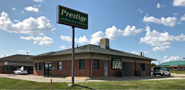
Property Record
1039 Peoples Sq, Waterloo, IA 50702

NEARBY LISTINGS FOR SALE OR LEASE
Property Detail
1039 Peoples Sq
Waterloo-Cedar Falls, IA
Kaspend Addition A Replat Of
8813-04-478-047
KASPEND ADDITION A REPLAT OF PART OF TRACT C GRANGERS SECOND ADDITION AND A PART OF VACATED WEST SAN MARNAN DR AND VACATED
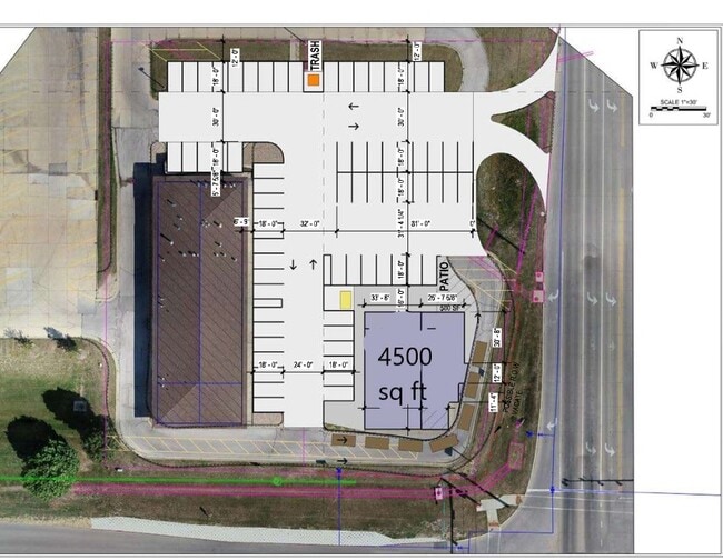
Stripcommercialcenter
Black Hawk
X
Iowa
19013C0303G
2,118
2024
0.74 AC
2025
Iowa City/Waterloo
001302
Other Market Areas
4,057 SF
DEMOGRAPHICS near 1039 Peoples Sq
1 Mile
3 Mile
5 Mile
2024 Total Population
7,156
39,728
78,637
2029 Population
7,087
39,460
78,163
Pop Growth 2024-2029
(0.96%)
(0.67%)
(0.60%)
Average Age
41
39
39
2024 Total Households
3,173
17,207
34,022
HH Growth 2024-2029
(0.91%)
(0.64%)
(0.59%)
Median Household Inc
$64,654
$55,461
$54,155
Avg Household Size
2.20
2.20
2.20
2024 Avg HH Vehicles
2.00
2.00
2.00
Median Home Value
$166,617
$154,903
$145,816
Median Year Built
1970
1962
1963
Nearby Places
Map Layers
Map Styles
 Street
 Aerial
- Restaurants
- Banks
- Shops
- Fitness
- Groceries
SALE & LEASE HISTORY
LISTING DATE
SALE/LEASE

Aug 09, 2018
For Sale
Nearby Properties
Address
Land Use
TOTAL SIZE
Lot Size
Zoning
Address
Land Use
TOTAL SIZE
Lot Size
Zoning
156,098 SF
52.58 AC
Address
Land Use
TOTAL SIZE
Lot Size
Zoning
596,653 SF
31.45 AC
Address
Land Use
TOTAL SIZE
Lot Size
Zoning
108,671 SF
3.72 AC
Address
Land Use
TOTAL SIZE
Lot Size
Zoning
186,130 SF
10.89 AC
Address
Land Use
TOTAL SIZE
Lot Size
Zoning
622 SF
106.81 AC
Address
Land Use
TOTAL SIZE
Lot Size
Zoning
117,384 SF
19.56 AC
Address
Land Use
TOTAL SIZE
Lot Size
Zoning
172,479 SF
9.39 AC
Address
Land Use
TOTAL SIZE
Lot Size
Zoning
341 SF
1.83 AC
Address
Land Use
TOTAL SIZE
Lot Size
Zoning
101,633 SF
7 AC
Address
Land Use
TOTAL SIZE
Lot Size
Zoning
110,177 SF
1.19 AC
Address
Land Use
TOTAL SIZE
Lot Size
Zoning
202,974 SF
19.11 AC
Address
Land Use
TOTAL SIZE
Lot Size
Zoning
174,244 SF
34.27 AC
Address
Land Use
TOTAL SIZE
Lot Size
Zoning
2,735 SF
158.87 AC
Address
Land Use
TOTAL SIZE
Lot Size
Zoning
59,565 SF
0.28 AC
Address
Land Use
TOTAL SIZE
Lot Size
Zoning
205,163 SF
15 AC
Address
Land Use
TOTAL SIZE
Lot Size
Zoning
115,819 SF
2.07 AC
Address
Land Use
TOTAL SIZE
Lot Size
Zoning
125,340 SF
0.80 AC
Address
Land Use
TOTAL SIZE
Lot Size
Zoning
197,968 SF
6.10 AC
Address
Land Use
TOTAL SIZE
Lot Size
Zoning
82,449 SF
10.62 AC
Address
Land Use
TOTAL SIZE
Lot Size
Zoning
157,119 SF
15.78 AC
Address
Land Use
TOTAL SIZE
Lot Size
Zoning
86,363 SF
21.46 AC
Address
Land Use
TOTAL SIZE
Lot Size
Zoning
960 SF
39.19 AC
Address
Land Use
TOTAL SIZE
Lot Size
Zoning
70,933 SF
27.58 AC
Address
Land Use
TOTAL SIZE
Lot Size
Zoning
102,131 SF
9.16 AC
Address
Land Use
TOTAL SIZE
Lot Size
Zoning
Address
Land Use
TOTAL SIZE
Lot Size
Zoning
71,035 SF
8.27 AC
Address
Land Use
TOTAL SIZE
Lot Size
Zoning
145,720 SF
17.98 AC
Address
Land Use
TOTAL SIZE
Lot Size
Zoning
84,388 SF
7.79 AC
Address
Land Use
TOTAL SIZE
Lot Size
Zoning
15,132 SF
Address
Land Use
TOTAL SIZE
Lot Size
Zoning
The World's #1 Commercial Real Estate Marketplace
Connect with us
© 2025 CoStar Group
The information above has been obtained from sources believed reliable. While we do not doubt its accuracy we have not verified it and make no guarantee, warranty or representation about it. It is your responsibility to independently confirm its accuracy and completeness. Any projections, opinions, assumptions, or estimates used are for example only and do not represent the current or future performance of the property. The value of this transaction to you depends on tax and other factors which should be evaluated by your tax, financial, and legal advisors. You and your advisors should conduct a careful, independent investigation of the property to determine to your satisfaction the suitability of the property for your needs.