Property Record
1039 Pulinski Rd, Warminster, PA 18974

Save to a Folder
{{folder.Name}}
{{folder.ListingIds.length}} Properties
{{folder.ListingIds.length}} Property
Create a New Folder
Property Detail
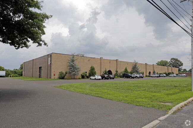
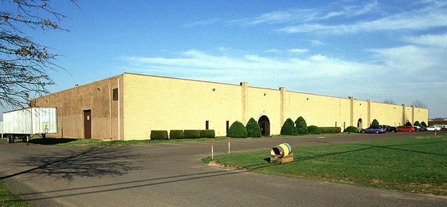
1039 Pulinski Rd
31-001-006-003
4.032AC MUSCARA IND PARK LOT3&4 500 ON POLINSKI
Warehouse
Bucks
I1
Pennsylvania
B and X Area of moderate flood hazard, usually the area between the limits of the 100-year and 500-year floods.
3,4
2025
4.03 AC
2026
Bucks
105008
Philadelphia
49,680 SF
Philadelphia-Camden-Wilmington, PA-NJ-DE-MD
NEARBY LISTINGS FOR SALE OR LEASE
DEMOGRAPHICS near 1039 Pulinski Rd
1 mile
3 mile
5 mile
2025 Total Population
2,801
50,897
146,693
2030 Population
2,814
51,311
148,486
Pop Growth 2025-2030
+ 0.46%
+ 0.81%
+ 1.22%
Average Age
44
45
44
2025 Total Households
954
19,653
55,617
HH Growth 2025-2030
+ 0.42%
+ 0.94%
+ 1.31%
Median Household Inc
$140,789
$109,684
$112,781
Avg Household Size
2.80
2.50
2.60
2025 Avg HH Vehicles
3.00
2.00
2.00
Median Home Value
$770,460
$476,176
$475,658
Median Year Built
1991
1977
1974
Nearby Places
Map Layers
Map Styles
 Street
 Aerial
Layers
 Traffic
 Biking
Places
Listings with unknown addresses are not visible on the map
- Restaurants
- Banks
- Shops
- Fitness
- Groceries
PUBLIC TRANSPORTATION
COMMUTER RAIL
Warminster (R2 - Southeastern Pennsylvania Transportation Authority Regional Rail (SEPTA Regional Rail))
Drive
Walk
Distance
Warminster (R2 - Southeastern Pennsylvania Transportation Authority Regional Rail (SEPTA Regional Rail))
7 min
2.9 mi
Hatboro (R2 - Southeastern Pennsylvania Transportation Authority Regional Rail (SEPTA Regional Rail))
Drive
Walk
Distance
Hatboro (R2 - Southeastern Pennsylvania Transportation Authority Regional Rail (SEPTA Regional Rail))
9 min
4.2 mi
AIRPORT
Trenton Mercer
Drive
Walk
Distance
Trenton Mercer
31 min
17.1 mi
Philadelphia International
Drive
Walk
Distance
Philadelphia International
60 min
38.6 mi
Lehigh Valley International
Drive
Walk
Distance
Lehigh Valley International
75 min
42.5 mi
Freight Ports
Port of Philadelphia
Drive
Walk
Distance
Port of Philadelphia
40 min
21.1 mi
Nearby Properties
Address
Land Use
TOTAL SIZE
Lot Size
Zoning
Address
Land Use
TOTAL SIZE
Lot Size
Zoning
256,810 SF
36.13 AC
C
Address
Land Use
TOTAL SIZE
Lot Size
Zoning
29,308 SF
15.96 AC
I
Address
Land Use
TOTAL SIZE
Lot Size
Zoning
37,806 SF
21.50 AC
R5
Address
Land Use
TOTAL SIZE
Lot Size
Zoning
25,021 SF
10.82 AC
I
Address
Land Use
TOTAL SIZE
Lot Size
Zoning
249,396 SF
18.70 AC
I
Address
Land Use
TOTAL SIZE
Lot Size
Zoning
56,440 SF
11.55 AC
R2
Address
Land Use
TOTAL SIZE
Lot Size
Zoning
10,000 SF
10.54 AC
MF1
Address
Land Use
TOTAL SIZE
Lot Size
Zoning
140,444 SF
15.31 AC
I
Address
Land Use
TOTAL SIZE
Lot Size
Zoning
73,663 SF
14.84 AC
MF-1
Address
Land Use
TOTAL SIZE
Lot Size
Zoning
110,473 SF
13.96 AC
C
Address
Land Use
TOTAL SIZE
Lot Size
Zoning
12,000 SF
12.57 AC
MF1
Address
Land Use
TOTAL SIZE
Lot Size
Zoning
104,516 SF
13.98 AC
SC
Address
Land Use
TOTAL SIZE
Lot Size
Zoning
89,417 SF
13.30 AC
CR
Address
Land Use
TOTAL SIZE
Lot Size
Zoning
10,000 SF
9.10 AC
MF1
Address
Land Use
TOTAL SIZE
Lot Size
Zoning
94,271 SF
8.96 AC
C3
Address
Land Use
TOTAL SIZE
Lot Size
Zoning
155,000 SF
16.18 AC
I1
Address
Land Use
TOTAL SIZE
Lot Size
Zoning
56,191 SF
9.15 AC
SC
Address
Land Use
TOTAL SIZE
Lot Size
Zoning
19.90 AC
Address
Land Use
TOTAL SIZE
Lot Size
Zoning
117,282 SF
12.20 AC
SC
Address
Land Use
TOTAL SIZE
Lot Size
Zoning
61,048 SF
14.62 AC
PK
Address
Land Use
TOTAL SIZE
Lot Size
Zoning
212,642 SF
18.81 AC
I
Address
Land Use
TOTAL SIZE
Lot Size
Zoning
25,500 SF
9 AC
I
Address
Land Use
TOTAL SIZE
Lot Size
Zoning
607 SF
87.56 AC
MF2
Address
Land Use
TOTAL SIZE
Lot Size
Zoning
113,256 SF
12.59 AC
HC
Address
Land Use
TOTAL SIZE
Lot Size
Zoning
222,666 SF
11.95 AC
I
Address
Land Use
TOTAL SIZE
Lot Size
Zoning
97,361 SF
5.62 AC
R2
Address
Land Use
TOTAL SIZE
Lot Size
Zoning
800 SF
147.62 AC
QA
Address
Land Use
TOTAL SIZE
Lot Size
Zoning
112,412 SF
11.24 AC
I
Address
Land Use
TOTAL SIZE
Lot Size
Zoning
92,454 SF
12.48 AC
R1
Address
Land Use
TOTAL SIZE
Lot Size
Zoning
137,592 SF
18.52 AC
LI
The World's #1 Commercial Real Estate Marketplace
Connect with us
© 2026 CoStar Group
The information above has been obtained from sources believed reliable. While we do not doubt its accuracy we have not verified it and make no guarantee, warranty or representation about it. It is your responsibility to independently confirm its accuracy and completeness. Any projections, opinions, assumptions, or estimates used are for example only and do not represent the current or future performance of the property. The value of this transaction to you depends on tax and other factors which should be evaluated by your tax, financial, and legal advisors. You and your advisors should conduct a careful, independent investigation of the property to determine to your satisfaction the suitability of the property for your needs.