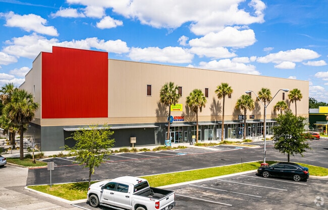
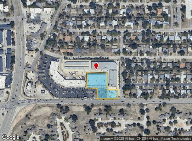
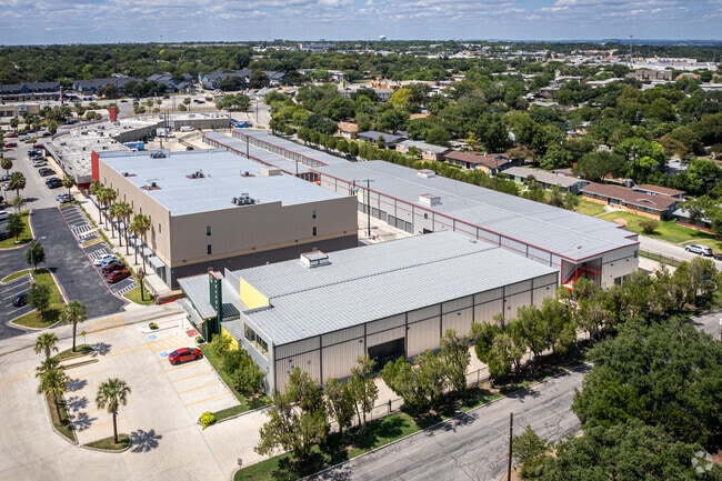
Property Record
1039 Rittiman Rd, San Antonio, TX 78218
Current Lease Availabilities
NEARBY LISTINGS FOR SALE OR LEASE
Property Detail
1039 Rittiman Rd
San Antonio-New Braunfels, TX
Ncb 11003 (Sam Houston Bakke (Replat))
11003-004-0100
NCB 11003 (SAM HOUSTON BAKKE (REPLAT)), BLOCK 4 LOT 10 2017-CREATED PER AMMENDING PLAT 9704/75-78 FILED 07-29-2016 2011-NEW ACCT PER SPLIT PER PLAT 9616/90 FILED 7/30/2010
Publicstorage
Bexar
X
Texas
48029C0406H
10
2024
1.40 AC
2025
Northeast
120503
San Antonio
78,285 SF
DEMOGRAPHICS near 1039 Rittiman Rd
1 Mile
3 Mile
5 Mile
2024 Total Population
10,969
90,114
254,850
2029 Population
11,687
96,207
272,452
Pop Growth 2024-2029
+ 6.55%
+ 6.76%
+ 6.91%
Average Age
37
38
37
2024 Total Households
4,414
36,458
98,806
HH Growth 2024-2029
+ 6.52%
+ 6.93%
+ 7.12%
Median Household Inc
$51,321
$57,432
$54,723
Avg Household Size
2.20
2.30
2.40
2024 Avg HH Vehicles
1.00
2.00
2.00
Median Home Value
$183,333
$312,256
$202,548
Median Year Built
1968
1972
1975
Nearby Places
Map Layers
Map Styles
 Street
 Aerial
- Restaurants
- Banks
- Shops
- Fitness
- Groceries
PUBLIC TRANSPORTATION
COMMUTER RAIL
San Antonio Amtrak Station (Sunset Limited - Amtrak, Texas Eagle - Amtrak)
DRIVE
WALK
Distance
San Antonio Amtrak Station (Sunset Limited - Amtrak, Texas Eagle - Amtrak)
14 min
7.6 mi
AIRPORT
San Antonio International
DRIVE
WALK
Distance
San Antonio International
10 min
5.2 mi
Freight Ports
Calhoun Port
DRIVE
WALK
Distance
Calhoun Port
179 min
147.1 mi
Nearby Properties
Address
Land Use
TOTAL SIZE
Lot Size
Zoning
Address
Land Use
TOTAL SIZE
Lot Size
Zoning
2,544.56 AC
Address
Land Use
TOTAL SIZE
Lot Size
Zoning
1,649,488 SF
70 AC
Address
Land Use
TOTAL SIZE
Lot Size
Zoning
246,000 SF
22.54 AC
Address
Land Use
TOTAL SIZE
Lot Size
Zoning
25,513 SF
18.14 AC
Address
Land Use
TOTAL SIZE
Lot Size
Zoning
239,264 SF
9.02 AC
Address
Land Use
TOTAL SIZE
Lot Size
Zoning
316,556 SF
6.56 AC
Address
Land Use
TOTAL SIZE
Lot Size
Zoning
10,342 SF
1.41 AC
Address
Land Use
TOTAL SIZE
Lot Size
Zoning
71,253 SF
25.52 AC
Address
Land Use
TOTAL SIZE
Lot Size
Zoning
23,738 SF
4.84 AC
Address
Land Use
TOTAL SIZE
Lot Size
Zoning
268,495 SF
13.04 AC
Address
Land Use
TOTAL SIZE
Lot Size
Zoning
307,193 SF
7.18 AC
Address
Land Use
TOTAL SIZE
Lot Size
Zoning
157,762 SF
9.26 AC
Address
Land Use
TOTAL SIZE
Lot Size
Zoning
139,410 SF
35.75 AC
Address
Land Use
TOTAL SIZE
Lot Size
Zoning
598,070 SF
46.05 AC
Address
Land Use
TOTAL SIZE
Lot Size
Zoning
328,605 SF
25.69 AC
Address
Land Use
TOTAL SIZE
Lot Size
Zoning
74,510 SF
6.58 AC
Address
Land Use
TOTAL SIZE
Lot Size
Zoning
279,012 SF
12.17 AC
Address
Land Use
TOTAL SIZE
Lot Size
Zoning
273,516 SF
17.50 AC
Address
Land Use
TOTAL SIZE
Lot Size
Zoning
132.44 AC
Address
Land Use
TOTAL SIZE
Lot Size
Zoning
110,252 SF
20.04 AC
Address
Land Use
TOTAL SIZE
Lot Size
Zoning
265,015 SF
12.81 AC
Address
Land Use
TOTAL SIZE
Lot Size
Zoning
337,468 SF
21.84 AC
Address
Land Use
TOTAL SIZE
Lot Size
Zoning
275,327 SF
13.52 AC
Address
Land Use
TOTAL SIZE
Lot Size
Zoning
373,134 SF
16.29 AC
Address
Land Use
TOTAL SIZE
Lot Size
Zoning
364,894 SF
10.28 AC
Address
Land Use
TOTAL SIZE
Lot Size
Zoning
300,987 SF
29.07 AC
Address
Land Use
TOTAL SIZE
Lot Size
Zoning
222,865 SF
17.75 AC
Address
Land Use
TOTAL SIZE
Lot Size
Zoning
300,555 SF
29.35 AC
Address
Land Use
TOTAL SIZE
Lot Size
Zoning
106,139 SF
5.84 AC
Address
Land Use
TOTAL SIZE
Lot Size
Zoning
101,218 SF
7.78 AC
The World's #1 Commercial Real Estate Marketplace
Connect with us
© 2025 CoStar Group
The information above has been obtained from sources believed reliable. While we do not doubt its accuracy we have not verified it and make no guarantee, warranty or representation about it. It is your responsibility to independently confirm its accuracy and completeness. Any projections, opinions, assumptions, or estimates used are for example only and do not represent the current or future performance of the property. The value of this transaction to you depends on tax and other factors which should be evaluated by your tax, financial, and legal advisors. You and your advisors should conduct a careful, independent investigation of the property to determine to your satisfaction the suitability of the property for your needs.