Property Record
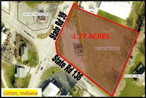
104 E Main St, Lizton, IN 46149


Property Detail
104 E Main St
32-03-28-300-002.000-021
PT NW SW 28-17-1W .39 AC
Commercialacreage
Hendricks
B and X Area of moderate flood hazard, usually the area between the limits of the 100-year and 500-year floods.
Indiana
2025
0.39 AC
2025
Hendricks County
210400
Indianapolis
1,296 SF
Indianapolis-Carmel-Greenwood, IN
NEARBY LISTINGS FOR SALE OR LEASE
DEMOGRAPHICS near 104 E Main St
1 mile
3 mile
5 mile
2025 Total Population
819
2,525
7,447
2030 Population
878
2,704
8,005
Pop Growth 2025-2030
+ 7.20%
+ 7.09%
+ 7.49%
Average Age
41
42
41
2025 Total Households
310
949
2,773
HH Growth 2025-2030
+ 7.42%
+ 7.38%
+ 7.79%
Median Household Inc
$78,532
$90,050
$105,273
Avg Household Size
2.60
2.70
2.70
2025 Avg HH Vehicles
3.00
3.00
3.00
Median Home Value
$249,418
$280,113
$302,554
Median Year Built
1981
1983
1989
Nearby Places
Map Layers
Map Styles
 Street
 Aerial
Layers
 Traffic
 Biking
Places
Listings with unknown addresses are not visible on the map
- Restaurants
- Banks
- Shops
- Fitness
- Groceries
PUBLIC TRANSPORTATION
AIRPORT
Indianapolis International
Drive
Walk
Distance
Indianapolis International
39 min
25.7 mi
SALE & LEASE HISTORY
LISTING DATE
SALE/LEASE

Mar 22, 2017
For Sale
Jan 23, 2018
For Sale
Nearby Properties
Address
Land Use
TOTAL SIZE
Lot Size
Zoning
Address
Land Use
TOTAL SIZE
Lot Size
Zoning
32,280 SF
39.18 AC
Address
Land Use
TOTAL SIZE
Lot Size
Zoning
35,500 SF
5 AC
Address
Land Use
TOTAL SIZE
Lot Size
Zoning
15,000 SF
10 AC
Address
Land Use
TOTAL SIZE
Lot Size
Zoning
2,400 SF
91.37 AC
Address
Land Use
TOTAL SIZE
Lot Size
Zoning
26,058 SF
1.84 AC
Address
Land Use
TOTAL SIZE
Lot Size
Zoning
3,663 SF
2.08 AC
Address
Land Use
TOTAL SIZE
Lot Size
Zoning
2,800 SF
1.25 AC
Address
Land Use
TOTAL SIZE
Lot Size
Zoning
9,504 SF
1.37 AC
Address
Land Use
TOTAL SIZE
Lot Size
Zoning
570 SF
38.04 AC
Address
Land Use
TOTAL SIZE
Lot Size
Zoning
3,840 SF
7.90 AC
Address
Land Use
TOTAL SIZE
Lot Size
Zoning
5,151 SF
2.01 AC
Address
Land Use
TOTAL SIZE
Lot Size
Zoning
4,000 SF
1.18 AC
Address
Land Use
TOTAL SIZE
Lot Size
Zoning
7,686 SF
1.60 AC
Address
Land Use
TOTAL SIZE
Lot Size
Zoning
4,649 SF
2.97 AC
Address
Land Use
TOTAL SIZE
Lot Size
Zoning
5,160 SF
6.70 AC
Address
Land Use
TOTAL SIZE
Lot Size
Zoning
Address
Land Use
TOTAL SIZE
Lot Size
Zoning
13,260 SF
2.97 AC
Address
Land Use
TOTAL SIZE
Lot Size
Zoning
2,828 SF
0.45 AC
Address
Land Use
TOTAL SIZE
Lot Size
Zoning
6,865 SF
3.09 AC
Address
Land Use
TOTAL SIZE
Lot Size
Zoning
6,720 SF
1.52 AC
Address
Land Use
TOTAL SIZE
Lot Size
Zoning
116.14 AC
ZO01
Address
Land Use
TOTAL SIZE
Lot Size
Zoning
1,284 SF
83.85 AC
Address
Land Use
TOTAL SIZE
Lot Size
Zoning
3,360 SF
0.12 AC
Address
Land Use
TOTAL SIZE
Lot Size
Zoning
8,688 SF
0.37 AC
Address
Land Use
TOTAL SIZE
Lot Size
Zoning
1,656 SF
14.70 AC
Address
Land Use
TOTAL SIZE
Lot Size
Zoning
Address
Land Use
TOTAL SIZE
Lot Size
Zoning
880 SF
1.33 AC
The World's #1 Commercial Real Estate Marketplace
Connect with us
© 2026 CoStar Group
The information above has been obtained from sources believed reliable. While we do not doubt its accuracy we have not verified it and make no guarantee, warranty or representation about it. It is your responsibility to independently confirm its accuracy and completeness. Any projections, opinions, assumptions, or estimates used are for example only and do not represent the current or future performance of the property. The value of this transaction to you depends on tax and other factors which should be evaluated by your tax, financial, and legal advisors. You and your advisors should conduct a careful, independent investigation of the property to determine to your satisfaction the suitability of the property for your needs.