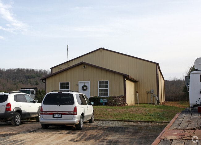
Property Record
104 Eastwind Dr, Hendersonville, NC 28739


NEARBY LISTINGS FOR SALE OR LEASE
-
-
View all Hendersonville listings for sale on LoopNet.com
Property Detail
104 Eastwind Dr
Asheville, NC
Etowah Estates
9933823
ETOWAH ESTATES MHP PLA-195A
Autorepair
Henderson
AE
North Carolina
3700953900J
378
2025
10.36 AC
2025
Henderson County
930703
Asheville
1,200 SF
DEMOGRAPHICS near 104 Eastwind Dr
1 Mile
3 Mile
5 Mile
2024 Total Population
643
11,156
26,194
2029 Population
659
11,587
27,235
Pop Growth 2024-2029
+ 2.49%
+ 3.86%
+ 3.97%
Average Age
48
48
49
2024 Total Households
280
4,781
11,231
HH Growth 2024-2029
+ 2.50%
+ 3.87%
+ 4.02%
Median Household Inc
$88,157
$68,461
$72,412
Avg Household Size
2.30
2.30
2.30
2024 Avg HH Vehicles
2.00
2.00
2.00
Median Home Value
$297,530
$321,096
$336,967
Median Year Built
1992
1992
1988
Nearby Places
Map Layers
Map Styles
 Street
 Aerial
- Restaurants
- Banks
- Shops
- Fitness
- Groceries
PUBLIC TRANSPORTATION
AIRPORT
Asheville Regional
DRIVE
WALK
Distance
Asheville Regional
23 min
11.7 mi
Freight Ports
North Charleston Terminal
DRIVE
WALK
Distance
North Charleston Terminal
282 min
245.2 mi
Nearby Properties
Address
Land Use
TOTAL SIZE
Lot Size
Zoning
Address
Land Use
TOTAL SIZE
Lot Size
Zoning
35.90 AC
10005135~R
Address
Land Use
TOTAL SIZE
Lot Size
Zoning
43,839 SF
10.87 AC
9933934~R1
Address
Land Use
TOTAL SIZE
Lot Size
Zoning
6,955 SF
173.84 AC
9963128~R1
Address
Land Use
TOTAL SIZE
Lot Size
Zoning
13,600 SF
4.43 AC
10012116~C
Address
Land Use
TOTAL SIZE
Lot Size
Zoning
40,940 SF
7.39 AC
9928960~CC
Address
Land Use
TOTAL SIZE
Lot Size
Zoning
4,250 SF
3.67 AC
10007980~C
Address
Land Use
TOTAL SIZE
Lot Size
Zoning
23,112 SF
9.55 AC
9902435~I
Address
Land Use
TOTAL SIZE
Lot Size
Zoning
44,884 SF
4.55 AC
1018998~CC
Address
Land Use
TOTAL SIZE
Lot Size
Zoning
36.01 AC
10008054~M
Address
Land Use
TOTAL SIZE
Lot Size
Zoning
4,281 SF
88.88 AC
1008348~R2
Address
Land Use
TOTAL SIZE
Lot Size
Zoning
16,620 SF
2.76 AC
9933590~R1
Address
Land Use
TOTAL SIZE
Lot Size
Zoning
22,068 SF
3.05 AC
1012993~CC
Address
Land Use
TOTAL SIZE
Lot Size
Zoning
8,048 SF
2.30 AC
1003374~CC
Address
Land Use
TOTAL SIZE
Lot Size
Zoning
15,008 SF
1.72 AC
9926305~R2
Address
Land Use
TOTAL SIZE
Lot Size
Zoning
6,720 SF
71.05 AC
10009792~R
Address
Land Use
TOTAL SIZE
Lot Size
Zoning
56,440 SF
5.16 AC
401929~R2R
Address
Land Use
TOTAL SIZE
Lot Size
Zoning
10,126 SF
3.07 AC
9974230~CC
Address
Land Use
TOTAL SIZE
Lot Size
Zoning
18,212 SF
0.87 AC
9933816~LC
Address
Land Use
TOTAL SIZE
Lot Size
Zoning
2,334 SF
5.11 AC
9933856~R1
Address
Land Use
TOTAL SIZE
Lot Size
Zoning
3,936 SF
2.46 AC
1008415~CC
Address
Land Use
TOTAL SIZE
Lot Size
Zoning
19,880 SF
1.21 AC
10007979~C
Address
Land Use
TOTAL SIZE
Lot Size
Zoning
3,900 SF
5.93 AC
9905114~MR
Address
Land Use
TOTAL SIZE
Lot Size
Zoning
7,304 SF
1.90 AC
10007087~C
Address
Land Use
TOTAL SIZE
Lot Size
Zoning
52.30 AC
10013369~R
Address
Land Use
TOTAL SIZE
Lot Size
Zoning
4,536 SF
1.28 AC
802874~R1
Address
Land Use
TOTAL SIZE
Lot Size
Zoning
4,636 SF
1.53 AC
9961034~CC
Address
Land Use
TOTAL SIZE
Lot Size
Zoning
3,200 SF
4.03 AC
9902450~CC
Address
Land Use
TOTAL SIZE
Lot Size
Zoning
5,400 SF
0.95 AC
1008414~CC
The World's #1 Commercial Real Estate Marketplace
Connect with us
© 2025 CoStar Group
The information above has been obtained from sources believed reliable. While we do not doubt its accuracy we have not verified it and make no guarantee, warranty or representation about it. It is your responsibility to independently confirm its accuracy and completeness. Any projections, opinions, assumptions, or estimates used are for example only and do not represent the current or future performance of the property. The value of this transaction to you depends on tax and other factors which should be evaluated by your tax, financial, and legal advisors. You and your advisors should conduct a careful, independent investigation of the property to determine to your satisfaction the suitability of the property for your needs.