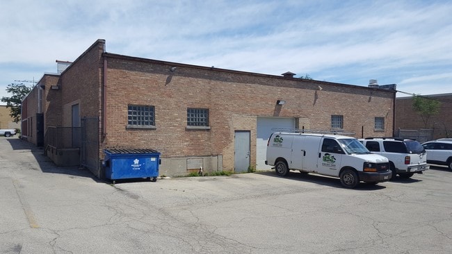
Property Record
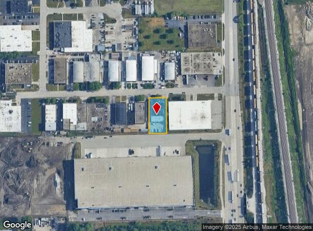
104 Gateway Rd, Bensenville, IL 60106
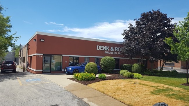

This Property Is For Sale
NEARBY LISTINGS FOR SALE OR LEASE
Property Detail
104 Gateway Rd
Chicago-Naperville-Elgin, IL-IN-WI
Bensenville Ind Sub
03-14-207-005
BENSENVILLE IND SUB W 1/2
Industrialgeneral
DuPage
X
Illinois
17043C0079J
11
2024
0.46 AC
2024
O'Hare
840000
Chicago
7,627 SF
DEMOGRAPHICS near 104 Gateway Rd
1 Mile
3 Mile
5 Mile
2024 Total Population
8,234
37,956
212,554
2029 Population
8,127
36,945
207,135
Pop Growth 2024-2029
(1.30%)
(2.66%)
(2.55%)
Average Age
39
41
41
2024 Total Households
2,701
13,357
75,836
HH Growth 2024-2029
(1.37%)
(2.85%)
(2.76%)
Median Household Inc
$69,574
$76,128
$77,332
Avg Household Size
2.90
2.70
2.70
2024 Avg HH Vehicles
2.00
2.00
2.00
Median Home Value
$239,366
$273,309
$277,403
Median Year Built
1971
1969
1967
Nearby Places
- Restaurants
- Banks
- Shops
- Fitness
- Groceries
PUBLIC TRANSPORTATION
COMMUTER RAIL
Bensenville Station (Milwaukee District West Line - Northeast Illinois Regional Commuter Railroad (Metra))
DRIVE
WALK
Distance
Bensenville Station (Milwaukee District West Line - Northeast Illinois Regional Commuter Railroad (Metra))
2 min
14 min
0.8 mi
Wood Dale Station (Milwaukee District West Line - Northeast Illinois Regional Commuter Railroad (Metra))
DRIVE
WALK
Distance
Wood Dale Station (Milwaukee District West Line - Northeast Illinois Regional Commuter Railroad (Metra))
4 min
2.2 mi
AIRPORT
Chicago O'Hare International
DRIVE
WALK
Distance
Chicago O'Hare International
12 min
7.5 mi
Chicago Midway International
DRIVE
WALK
Distance
Chicago Midway International
34 min
20.4 mi
Freight Ports
Port Milwaukee
DRIVE
WALK
Distance
Port Milwaukee
96 min
81.0 mi
Nearby Properties
Address
Land Use
TOTAL SIZE
Lot Size
Zoning
Address
Land Use
TOTAL SIZE
Lot Size
Zoning
108,216 SF
7.87 AC
Address
Land Use
TOTAL SIZE
Lot Size
Zoning
Address
Land Use
TOTAL SIZE
Lot Size
Zoning
310,751 SF
15.04 AC
Address
Land Use
TOTAL SIZE
Lot Size
Zoning
333,258 SF
9.48 AC
Address
Land Use
TOTAL SIZE
Lot Size
Zoning
179,780 SF
8.12 AC
I
Address
Land Use
TOTAL SIZE
Lot Size
Zoning
17.67 AC
Address
Land Use
TOTAL SIZE
Lot Size
Zoning
4,100 SF
PD 0
Address
Land Use
TOTAL SIZE
Lot Size
Zoning
17.73 AC
Address
Land Use
TOTAL SIZE
Lot Size
Zoning
14.76 AC
Address
Land Use
TOTAL SIZE
Lot Size
Zoning
15.32 AC
Address
Land Use
TOTAL SIZE
Lot Size
Zoning
15.29 AC
Address
Land Use
TOTAL SIZE
Lot Size
Zoning
28.36 AC
Address
Land Use
TOTAL SIZE
Lot Size
Zoning
14.35 AC
Address
Land Use
TOTAL SIZE
Lot Size
Zoning
469,492 SF
14.87 AC
I
Address
Land Use
TOTAL SIZE
Lot Size
Zoning
Address
Land Use
TOTAL SIZE
Lot Size
Zoning
4,100 SF
PD 0
Address
Land Use
TOTAL SIZE
Lot Size
Zoning
441,232 SF
34.52 AC
I
Address
Land Use
TOTAL SIZE
Lot Size
Zoning
208,000 SF
10.35 AC
Address
Land Use
TOTAL SIZE
Lot Size
Zoning
132,699 SF
6.74 AC
Address
Land Use
TOTAL SIZE
Lot Size
Zoning
338,816 SF
16.84 AC
I
Address
Land Use
TOTAL SIZE
Lot Size
Zoning
193,020 SF
8.94 AC
I
Address
Land Use
TOTAL SIZE
Lot Size
Zoning
189,290 SF
9.51 AC
Address
Land Use
TOTAL SIZE
Lot Size
Zoning
186,486 SF
2.43 AC
A
Address
Land Use
TOTAL SIZE
Lot Size
Zoning
256,686 SF
10.60 AC
I
Address
Land Use
TOTAL SIZE
Lot Size
Zoning
15.33 AC
M
Address
Land Use
TOTAL SIZE
Lot Size
Zoning
9.59 AC
Address
Land Use
TOTAL SIZE
Lot Size
Zoning
269,260 SF
10.61 AC
I
Address
Land Use
TOTAL SIZE
Lot Size
Zoning
79,628 SF
9.31 AC
I
Address
Land Use
TOTAL SIZE
Lot Size
Zoning
111,232 SF
5.41 AC
I
Address
Land Use
TOTAL SIZE
Lot Size
Zoning
179,220 SF
9.29 AC
I
The World's #1 Commercial Real Estate Marketplace
Connect with us
© 2025 CoStar Group
The information above has been obtained from sources believed reliable. While we do not doubt its accuracy we have not verified it and make no guarantee, warranty or representation about it. It is your responsibility to independently confirm its accuracy and completeness. Any projections, opinions, assumptions, or estimates used are for example only and do not represent the current or future performance of the property. The value of this transaction to you depends on tax and other factors which should be evaluated by your tax, financial, and legal advisors. You and your advisors should conduct a careful, independent investigation of the property to determine to your satisfaction the suitability of the property for your needs.