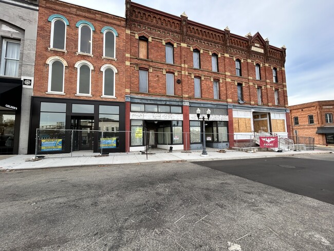
Property Record
96 N Howell St, Hillsdale, MI 49242
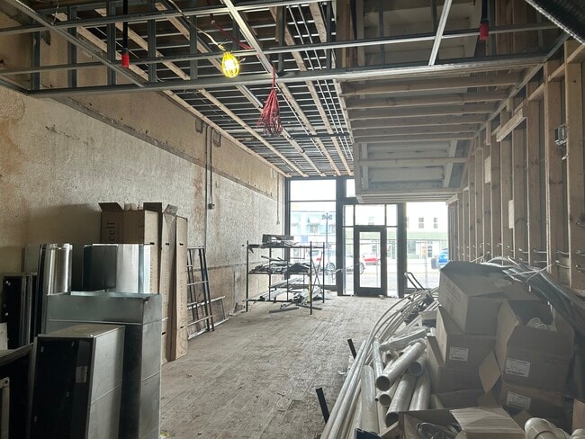
Current Lease Availabilities
NEARBY LISTINGS FOR SALE OR LEASE
-
-
View all Hillsdale listings for lease on LoopNet.com
Property Detail
96 N Howell St
Hillsdale, MI
Old Plat
006-227-282-06
S21 1/2 FT LOT 57
Miscellaneous
Hillsdale
X
Michigan
26059C0167D
57
0
0.09 AC
2025
Ann Arbor/Jackson
050700
Other Market Areas
DEMOGRAPHICS near 96 N Howell St
1 Mile
3 Mile
5 Mile
2024 Total Population
6,479
9,806
16,570
2029 Population
6,415
9,701
16,454
Pop Growth 2024-2029
(0.99%)
(1.07%)
(0.70%)
Average Age
36
38
40
2024 Total Households
2,442
3,760
6,492
HH Growth 2024-2029
(1.15%)
(1.28%)
(0.80%)
Median Household Inc
$48,165
$51,773
$53,204
Avg Household Size
2.30
2.30
2.30
2024 Avg HH Vehicles
2.00
2.00
2.00
Median Home Value
$129,053
$148,873
$154,467
Median Year Built
1953
1961
1966
Nearby Places
- Restaurants
- Banks
- Shops
- Fitness
- Groceries
Nearby Properties
Address
Land Use
TOTAL SIZE
Lot Size
Zoning
Address
Land Use
TOTAL SIZE
Lot Size
Zoning
77,528 SF
26.75 AC
C1
Address
Land Use
TOTAL SIZE
Lot Size
Zoning
171,597 SF
55.32 AC
C1
Address
Land Use
TOTAL SIZE
Lot Size
Zoning
Address
Land Use
TOTAL SIZE
Lot Size
Zoning
1,104 SF
48.64 AC
Address
Land Use
TOTAL SIZE
Lot Size
Zoning
135,240 SF
10 AC
RM1
Address
Land Use
TOTAL SIZE
Lot Size
Zoning
77,009 SF
6.03 AC
C1
Address
Land Use
TOTAL SIZE
Lot Size
Zoning
22,719 SF
1.90 AC
B2
Address
Land Use
TOTAL SIZE
Lot Size
Zoning
47,074 SF
6.62 AC
RM1
Address
Land Use
TOTAL SIZE
Lot Size
Zoning
128,464 SF
23.66 AC
PRF
Address
Land Use
TOTAL SIZE
Lot Size
Zoning
31,104 SF
6.36 AC
C1
Address
Land Use
TOTAL SIZE
Lot Size
Zoning
107,352 SF
2.67 AC
RM1
Address
Land Use
TOTAL SIZE
Lot Size
Zoning
20,696 SF
1.73 AC
C1
Address
Land Use
TOTAL SIZE
Lot Size
Zoning
31,500 SF
25 AC
C1
Address
Land Use
TOTAL SIZE
Lot Size
Zoning
100,000 SF
3.91 AC
RM1
Address
Land Use
TOTAL SIZE
Lot Size
Zoning
4,510 SF
B3
Address
Land Use
TOTAL SIZE
Lot Size
Zoning
17,856 SF
0.70 AC
C1
Address
Land Use
TOTAL SIZE
Lot Size
Zoning
114,879 SF
12.47 AC
B3
Address
Land Use
TOTAL SIZE
Lot Size
Zoning
1,212 SF
144 AC
PRF
Address
Land Use
TOTAL SIZE
Lot Size
Zoning
19,118 SF
8.85 AC
B1
Address
Land Use
TOTAL SIZE
Lot Size
Zoning
35,457 SF
3.35 AC
C1
Address
Land Use
TOTAL SIZE
Lot Size
Zoning
54,016 SF
4.84 AC
RM1
Address
Land Use
TOTAL SIZE
Lot Size
Zoning
81,225 SF
49.49 AC
I1
Address
Land Use
TOTAL SIZE
Lot Size
Zoning
133,532 SF
22.67 AC
I1
Address
Land Use
TOTAL SIZE
Lot Size
Zoning
8,865 SF
1.43 AC
C1
Address
Land Use
TOTAL SIZE
Lot Size
Zoning
12,400 SF
12.04 AC
B1
Address
Land Use
TOTAL SIZE
Lot Size
Zoning
0.93 AC
Address
Land Use
TOTAL SIZE
Lot Size
Zoning
Address
Land Use
TOTAL SIZE
Lot Size
Zoning
75,380 SF
5.53 AC
I1
Address
Land Use
TOTAL SIZE
Lot Size
Zoning
35,000 SF
4.73 AC
R1
Address
Land Use
TOTAL SIZE
Lot Size
Zoning
73,521 SF
7.33 AC
RM1
The World's #1 Commercial Real Estate Marketplace
Connect with us
© 2025 CoStar Group
The information above has been obtained from sources believed reliable. While we do not doubt its accuracy we have not verified it and make no guarantee, warranty or representation about it. It is your responsibility to independently confirm its accuracy and completeness. Any projections, opinions, assumptions, or estimates used are for example only and do not represent the current or future performance of the property. The value of this transaction to you depends on tax and other factors which should be evaluated by your tax, financial, and legal advisors. You and your advisors should conduct a careful, independent investigation of the property to determine to your satisfaction the suitability of the property for your needs.