Property Record
104 Oglesby Bridge Rd Se, Conyers, GA 30094
NEARBY LISTINGS FOR SALE OR LEASE
-
-
View all Conyers listings for sale on LoopNet.com
Property Detail
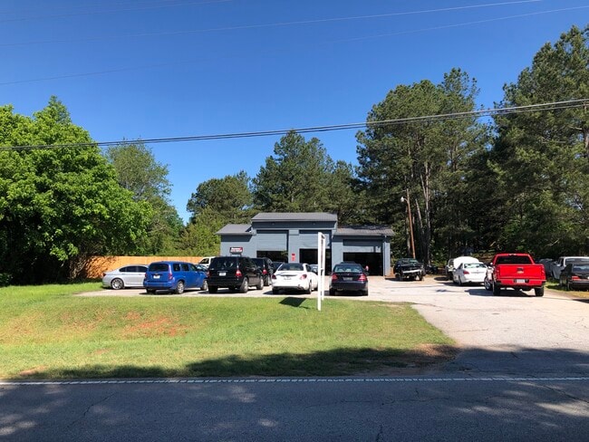
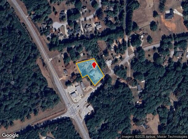
104 Oglesby Bridge Rd Se
032-0-01-009E
Commercial
Autorepair
LL112 LD11 NW/SIDE OGLESBY BRIDGE RD
X
Rockdale
13247C0158D
Georgia
2024
1.03 AC
2025
Lithonia/Conyers
060409
Atlanta
2,400 SF
Atlanta-Sandy Springs-Roswell, GA
DEMOGRAPHICS near 104 Oglesby Bridge Rd Se
1 Mile
3 Mile
5 Mile
2024 Total Population
3,431
20,489
58,794
2029 Population
3,549
21,482
62,250
Pop Growth 2024-2029
+ 3.44%
+ 4.85%
+ 5.88%
Average Age
42
42
41
2024 Total Households
1,217
7,176
20,269
HH Growth 2024-2029
+ 3.45%
+ 4.86%
+ 5.92%
Median Household Inc
$73,662
$83,175
$80,549
Avg Household Size
2.80
2.80
2.90
2024 Avg HH Vehicles
2.00
2.00
2.00
Median Home Value
$220,747
$239,951
$241,391
Median Year Built
1991
1989
1993
Nearby Places
Map Layers
Map Styles
 Street
 Aerial
- Restaurants
- Banks
- Shops
- Fitness
- Groceries
PUBLIC TRANSPORTATION
AIRPORT
Hartsfield - Jackson Atlanta International
DRIVE
WALK
Distance
Hartsfield - Jackson Atlanta International
48 min
30.6 mi
Freight Ports
Georgia Ports - Savannah
DRIVE
WALK
Distance
Georgia Ports - Savannah
268 min
234.4 mi
SALE & LEASE HISTORY
LISTING DATE
SALE/LEASE

May 16, 2021
For Sale
Nearby Properties
Address
Land Use
TOTAL SIZE
Lot Size
Zoning
Address
Land Use
TOTAL SIZE
Lot Size
Zoning
18,648 SF
2.48 AC
C1
Address
Land Use
TOTAL SIZE
Lot Size
Zoning
81,591 SF
12.80 AC
C2
Address
Land Use
TOTAL SIZE
Lot Size
Zoning
81,730 SF
17.98 AC
C1
Address
Land Use
TOTAL SIZE
Lot Size
Zoning
27.26 AC
R1
Address
Land Use
TOTAL SIZE
Lot Size
Zoning
50,096 SF
4.19 AC
C1
Address
Land Use
TOTAL SIZE
Lot Size
Zoning
9,779 SF
1.41 AC
C1
Address
Land Use
TOTAL SIZE
Lot Size
Zoning
17,700 SF
1.69 AC
C2
Address
Land Use
TOTAL SIZE
Lot Size
Zoning
63,328 SF
10.67 AC
C2
Address
Land Use
TOTAL SIZE
Lot Size
Zoning
64,800 SF
16.19 AC
AR
Address
Land Use
TOTAL SIZE
Lot Size
Zoning
18,751 SF
4.14 AC
C2/OI
Address
Land Use
TOTAL SIZE
Lot Size
Zoning
6,000 SF
2.61 AC
C1
Address
Land Use
TOTAL SIZE
Lot Size
Zoning
13,332 SF
1.17 AC
C1
Address
Land Use
TOTAL SIZE
Lot Size
Zoning
489.57 AC
AR
Address
Land Use
TOTAL SIZE
Lot Size
Zoning
17,558 SF
5.08 AC
AR/C1
Address
Land Use
TOTAL SIZE
Lot Size
Zoning
15,953 SF
1.94 AC
C1
Address
Land Use
TOTAL SIZE
Lot Size
Zoning
560.20 AC
AR
Address
Land Use
TOTAL SIZE
Lot Size
Zoning
24,750 SF
6 AC
R1
Address
Land Use
TOTAL SIZE
Lot Size
Zoning
3,500 SF
0.85 AC
C1
Address
Land Use
TOTAL SIZE
Lot Size
Zoning
13,182 SF
1.89 AC
CN
Address
Land Use
TOTAL SIZE
Lot Size
Zoning
5,880 SF
0.54 AC
C1
Address
Land Use
TOTAL SIZE
Lot Size
Zoning
8,964 SF
0.86 AC
C2
Address
Land Use
TOTAL SIZE
Lot Size
Zoning
12,600 SF
1.33 AC
C2
Address
Land Use
TOTAL SIZE
Lot Size
Zoning
12,546 SF
3.44 AC
OI/C
Address
Land Use
TOTAL SIZE
Lot Size
Zoning
11,876 SF
115.43 AC
R1
Address
Land Use
TOTAL SIZE
Lot Size
Zoning
12,934 SF
2.37 AC
E3
Address
Land Use
TOTAL SIZE
Lot Size
Zoning
2,128 SF
10 AC
AR
Address
Land Use
TOTAL SIZE
Lot Size
Zoning
10,112 SF
1.14 AC
C1
Address
Land Use
TOTAL SIZE
Lot Size
Zoning
16,620 SF
10.86 AC
AR
Address
Land Use
TOTAL SIZE
Lot Size
Zoning
6,161 SF
3.68 AC
C1
Address
Land Use
TOTAL SIZE
Lot Size
Zoning
26,000 SF
3.09 AC
C1
The World's #1 Commercial Real Estate Marketplace
Connect with us
© 2026 CoStar Group
The information above has been obtained from sources believed reliable. While we do not doubt its accuracy we have not verified it and make no guarantee, warranty or representation about it. It is your responsibility to independently confirm its accuracy and completeness. Any projections, opinions, assumptions, or estimates used are for example only and do not represent the current or future performance of the property. The value of this transaction to you depends on tax and other factors which should be evaluated by your tax, financial, and legal advisors. You and your advisors should conduct a careful, independent investigation of the property to determine to your satisfaction the suitability of the property for your needs.