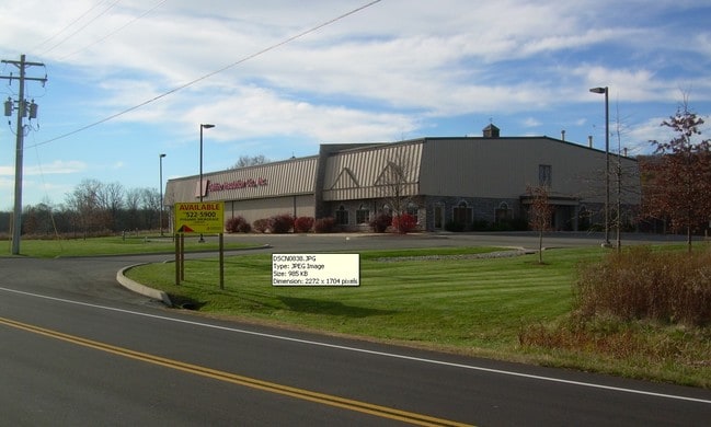
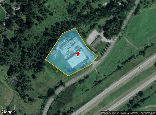
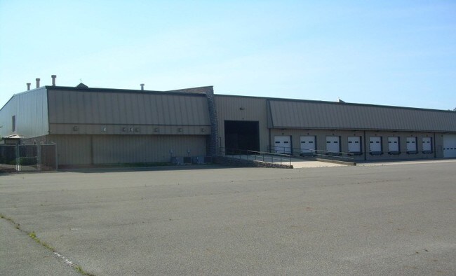
Property Record
104 Ohaire Rd, Middletown, NY 10941
NEARBY LISTINGS FOR SALE OR LEASE
Property Detail
104 Ohaire Rd
New York-Jersey City-White Plains, NY-NJ
Subdivision Property Shearman
335200-046-000-0001-076.200-0000
LT 2 SHEARMAN SUBMP 10131SEE ALSO L4069/280-7/5/94
Warehouse
Orange
X
New York
36071C0281E
76.20
2024
4.10 AC
2024
Orange County
011000
Northern New Jersey
20,000 SF
DEMOGRAPHICS near 104 Ohaire Rd
1 Mile
3 Mile
5 Mile
2024 Total Population
412
8,944
33,888
2029 Population
421
9,132
34,510
Pop Growth 2024-2029
+ 2.18%
+ 2.10%
+ 1.84%
Average Age
43
40
41
2024 Total Households
134
3,099
12,463
HH Growth 2024-2029
+ 2.24%
+ 2.19%
+ 1.93%
Median Household Inc
$102,083
$95,343
$92,884
Avg Household Size
2.70
2.70
2.60
2024 Avg HH Vehicles
2.00
2.00
2.00
Median Home Value
$373,809
$334,036
$320,745
Median Year Built
1979
1979
1979
Nearby Places
- Restaurants
- Banks
- Shops
- Fitness
- Groceries
PUBLIC TRANSPORTATION
COMMUTER RAIL
Campbell Hall (Bergen County/Port Jervis Line - NJ Transit Commuter Rail (NJ Transit), Main/Port Jervis Line - NJ Transit Commuter Rail (NJ Transit))
DRIVE
WALK
Distance
Campbell Hall (Bergen County/Port Jervis Line - NJ Transit Commuter Rail (NJ Transit), Main/Port Jervis Line - NJ Transit Commuter Rail (NJ Transit))
9 min
3.7 mi
Middletown New York (Bergen County/Port Jervis Line - NJ Transit Commuter Rail (NJ Transit), Main/Port Jervis Line - NJ Transit Commuter Rail (NJ Transit))
DRIVE
WALK
Distance
Middletown New York (Bergen County/Port Jervis Line - NJ Transit Commuter Rail (NJ Transit), Main/Port Jervis Line - NJ Transit Commuter Rail (NJ Transit))
11 min
5.0 mi
AIRPORT
New York Stewart International
DRIVE
WALK
Distance
New York Stewart International
25 min
14.8 mi
Freight Ports
Port Newark Container Terminal
DRIVE
WALK
Distance
Port Newark Container Terminal
98 min
72.2 mi
Nearby Properties
Address
Land Use
TOTAL SIZE
Lot Size
Zoning
Address
Land Use
TOTAL SIZE
Lot Size
Zoning
58.10 AC
R1
Address
Land Use
TOTAL SIZE
Lot Size
Zoning
330.10 AC
R4A*
Address
Land Use
TOTAL SIZE
Lot Size
Zoning
637,520 SF
44.70 AC
ENT-L
Address
Land Use
TOTAL SIZE
Lot Size
Zoning
4,022 SF
360.50 AC
R4A*
Address
Land Use
TOTAL SIZE
Lot Size
Zoning
55,200 SF
11.80 AC
R3A*
Address
Land Use
TOTAL SIZE
Lot Size
Zoning
136,784 SF
6 AC
O/R
Address
Land Use
TOTAL SIZE
Lot Size
Zoning
430,275 SF
35.60 AC
O/R
Address
Land Use
TOTAL SIZE
Lot Size
Zoning
10 AC
HRC4*
Address
Land Use
TOTAL SIZE
Lot Size
Zoning
1,240 SF
188 AC
R4A*
Address
Land Use
TOTAL SIZE
Lot Size
Zoning
60,120 SF
7.70 AC
O/R
Address
Land Use
TOTAL SIZE
Lot Size
Zoning
6,910 SF
186.70 AC
R4A
Address
Land Use
TOTAL SIZE
Lot Size
Zoning
312,196 SF
18.60 AC
ENT-L
Address
Land Use
TOTAL SIZE
Lot Size
Zoning
90,708 SF
9.50 AC
R1
Address
Land Use
TOTAL SIZE
Lot Size
Zoning
7,948 SF
115 AC
R4A
Address
Land Use
TOTAL SIZE
Lot Size
Zoning
90,708 SF
3.30 AC
R1
Address
Land Use
TOTAL SIZE
Lot Size
Zoning
90,708 SF
3.30 AC
R1
Address
Land Use
TOTAL SIZE
Lot Size
Zoning
53,185 SF
22.10 AC
ENT-L
Address
Land Use
TOTAL SIZE
Lot Size
Zoning
72,228 SF
9 AC
O/R
Address
Land Use
TOTAL SIZE
Lot Size
Zoning
7,080 SF
72.40 AC
R4A
Address
Land Use
TOTAL SIZE
Lot Size
Zoning
153,825 SF
56.60 AC
ENT-L
Address
Land Use
TOTAL SIZE
Lot Size
Zoning
62,770 SF
10.60 AC
IP
Address
Land Use
TOTAL SIZE
Lot Size
Zoning
48,088 SF
5.90 AC
R2
Address
Land Use
TOTAL SIZE
Lot Size
Zoning
11,645 SF
84.20 AC
R4A
Address
Land Use
TOTAL SIZE
Lot Size
Zoning
Address
Land Use
TOTAL SIZE
Lot Size
Zoning
264,708 SF
37.10 AC
O/R
Address
Land Use
TOTAL SIZE
Lot Size
Zoning
160,430 SF
26.80 AC
ENT-L
Address
Land Use
TOTAL SIZE
Lot Size
Zoning
26,617 SF
11.40 AC
HRC4*
Address
Land Use
TOTAL SIZE
Lot Size
Zoning
7.50 AC
HC
Address
Land Use
TOTAL SIZE
Lot Size
Zoning
16,624 SF
1.80 AC
IP
Address
Land Use
TOTAL SIZE
Lot Size
Zoning
7.70 AC
NB*
The World's #1 Commercial Real Estate Marketplace
Connect with us
© 2025 CoStar Group
The information above has been obtained from sources believed reliable. While we do not doubt its accuracy we have not verified it and make no guarantee, warranty or representation about it. It is your responsibility to independently confirm its accuracy and completeness. Any projections, opinions, assumptions, or estimates used are for example only and do not represent the current or future performance of the property. The value of this transaction to you depends on tax and other factors which should be evaluated by your tax, financial, and legal advisors. You and your advisors should conduct a careful, independent investigation of the property to determine to your satisfaction the suitability of the property for your needs.