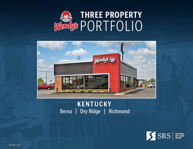
Property Record
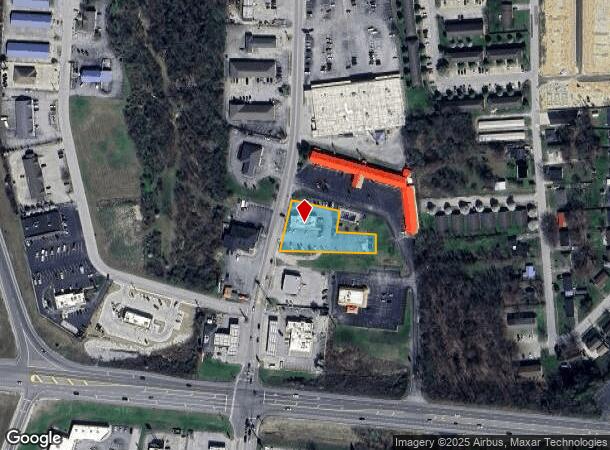
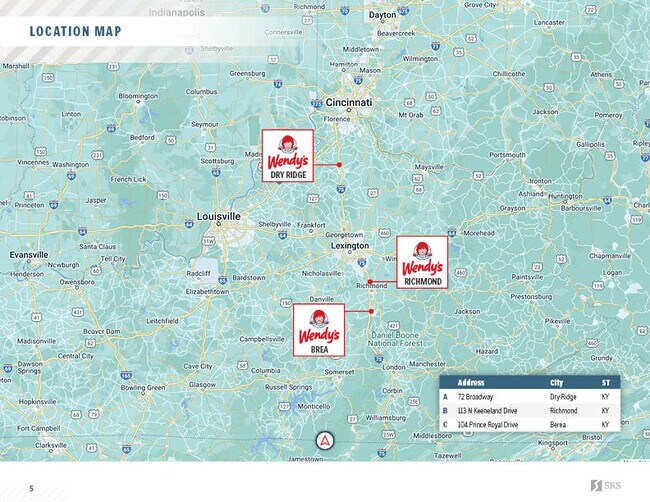
104 Prince Royal Dr, Berea, KY 40403
NEARBY LISTINGS FOR SALE OR LEASE
-
-
No Photo
-
View all Berea listings for sale on LoopNet.com
Property Detail
104 Prince Royal Dr
B001-0001-0029-A
WENDYS RESTAURANT
Recreationalentertainmentgeneral
Madison
X
Kentucky
21151C0358D
0.71 AC
2025
Georgetown/Richmond Area
2025
Other Market Areas
011201
Richmond-Berea, KY
2,780 SF
DEMOGRAPHICS near 104 Prince Royal Dr
1 Mile
3 Mile
5 Mile
2024 Total Population
4,462
18,717
24,190
2029 Population
4,851
20,386
26,332
Pop Growth 2024-2029
+ 8.72%
+ 8.92%
+ 8.85%
Average Age
37
38
38
2024 Total Households
1,881
7,315
9,382
HH Growth 2024-2029
+ 9.04%
+ 9.45%
+ 9.28%
Median Household Inc
$44,668
$49,685
$50,495
Avg Household Size
2.30
2.40
2.40
2024 Avg HH Vehicles
2.00
2.00
2.00
Median Home Value
$150,238
$173,399
$173,708
Median Year Built
1990
1989
1990
Nearby Places
Map Layers
Map Styles
 Street
 Aerial
- Restaurants
- Banks
- Shops
- Fitness
- Groceries
PUBLIC TRANSPORTATION
AIRPORT
Blue Grass
DRIVE
WALK
Distance
Blue Grass
61 min
47.0 mi
SALE & LEASE HISTORY
LISTING DATE
SALE/LEASE

Mar 23, 2022
For Sale
Nearby Properties
Address
Land Use
TOTAL SIZE
Lot Size
Zoning
Address
Land Use
TOTAL SIZE
Lot Size
Zoning
586,836 SF
40.67 AC
Address
Land Use
TOTAL SIZE
Lot Size
Zoning
Address
Land Use
TOTAL SIZE
Lot Size
Zoning
16,800 SF
41.52 AC
Address
Land Use
TOTAL SIZE
Lot Size
Zoning
151,767 SF
11.50 AC
Address
Land Use
TOTAL SIZE
Lot Size
Zoning
181,450 SF
48.71 AC
Address
Land Use
TOTAL SIZE
Lot Size
Zoning
11,500 SF
53.96 AC
Address
Land Use
TOTAL SIZE
Lot Size
Zoning
Address
Land Use
TOTAL SIZE
Lot Size
Zoning
Address
Land Use
TOTAL SIZE
Lot Size
Zoning
239,769 SF
46.50 AC
Address
Land Use
TOTAL SIZE
Lot Size
Zoning
18,056 SF
2.71 AC
Address
Land Use
TOTAL SIZE
Lot Size
Zoning
288,350 SF
27.61 AC
Address
Land Use
TOTAL SIZE
Lot Size
Zoning
0.90 AC
Address
Land Use
TOTAL SIZE
Lot Size
Zoning
2.20 AC
Address
Land Use
TOTAL SIZE
Lot Size
Zoning
3.10 AC
Address
Land Use
TOTAL SIZE
Lot Size
Zoning
129,090 SF
11.95 AC
Address
Land Use
TOTAL SIZE
Lot Size
Zoning
41,112 SF
1.90 AC
Address
Land Use
TOTAL SIZE
Lot Size
Zoning
78,511 SF
10.45 AC
Address
Land Use
TOTAL SIZE
Lot Size
Zoning
41,418 SF
7.16 AC
Address
Land Use
TOTAL SIZE
Lot Size
Zoning
1.62 AC
Address
Land Use
TOTAL SIZE
Lot Size
Zoning
4.91 AC
Address
Land Use
TOTAL SIZE
Lot Size
Zoning
25,270 SF
2.80 AC
Address
Land Use
TOTAL SIZE
Lot Size
Zoning
29,878 SF
1.20 AC
Address
Land Use
TOTAL SIZE
Lot Size
Zoning
0.86 AC
Address
Land Use
TOTAL SIZE
Lot Size
Zoning
3,146 SF
0.27 AC
Address
Land Use
TOTAL SIZE
Lot Size
Zoning
10,027 SF
2.10 AC
Address
Land Use
TOTAL SIZE
Lot Size
Zoning
6,240 SF
3.71 AC
Address
Land Use
TOTAL SIZE
Lot Size
Zoning
1.55 AC
Address
Land Use
TOTAL SIZE
Lot Size
Zoning
4,800 SF
1.19 AC
Address
Land Use
TOTAL SIZE
Lot Size
Zoning
29,005 SF
5.17 AC
Address
Land Use
TOTAL SIZE
Lot Size
Zoning
1,272 SF
3.11 AC
The World's #1 Commercial Real Estate Marketplace
Connect with us
© 2026 CoStar Group
The information above has been obtained from sources believed reliable. While we do not doubt its accuracy we have not verified it and make no guarantee, warranty or representation about it. It is your responsibility to independently confirm its accuracy and completeness. Any projections, opinions, assumptions, or estimates used are for example only and do not represent the current or future performance of the property. The value of this transaction to you depends on tax and other factors which should be evaluated by your tax, financial, and legal advisors. You and your advisors should conduct a careful, independent investigation of the property to determine to your satisfaction the suitability of the property for your needs.