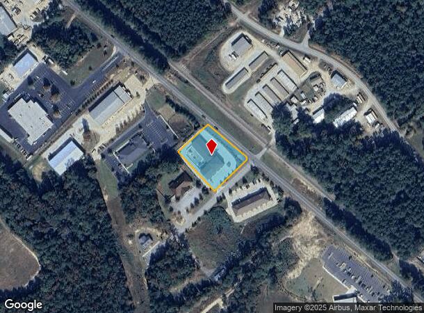
Property Record
104 Snapdragon Ct, Chapin, SC 29036

NEARBY LISTINGS FOR SALE OR LEASE
Property Detail
104 Snapdragon Ct
Columbia, SC
Legacy Park
000700-04-089
LEGACY PARK LOT 1
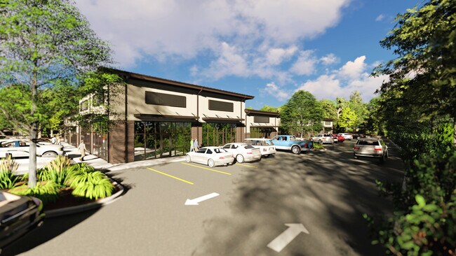
Daycare
Lexington
X
South Carolina
45063C0040J
1
2025
1.23 AC
2024
Dutch Fork/Irmo
021204
Columbia
11,300 SF
DEMOGRAPHICS near 104 Snapdragon Ct
1 mile
3 mile
5 mile
2024 Total Population
1,721
10,385
28,864
2029 Population
1,885
11,249
30,931
Pop Growth 2024-2029
+ 9.53%
+ 8.32%
+ 7.16%
Average Age
39
40
42
2024 Total Households
646
3,867
10,812
HH Growth 2024-2029
+ 9.60%
+ 8.43%
+ 7.38%
Median Household Inc
$72,142
$75,568
$102,491
Avg Household Size
2.60
2.60
2.60
2024 Avg HH Vehicles
2.00
2.00
2.00
Median Home Value
$224,117
$263,048
$330,417
Median Year Built
2002
2000
2001
Nearby Places
Map Layers
Map Styles
 Street
 Aerial
Transit
 Traffic
 Biking
Places
Listings with unknown addresses are not visible on the map
- Restaurants
- Banks
- Shops
- Fitness
- Groceries
PUBLIC TRANSPORTATION
AIRPORT
Columbia Metro
Drive
Walk
Distance
Columbia Metro
45 min
27.0 mi
SALE & LEASE HISTORY
LISTING DATE
SALE/LEASE

Feb 10, 2021
For Lease
Nearby Properties
Address
Land Use
TOTAL SIZE
Lot Size
Zoning
Address
Land Use
TOTAL SIZE
Lot Size
Zoning
20,344 SF
13.21 AC
RU
Address
Land Use
TOTAL SIZE
Lot Size
Zoning
10,764 SF
1.84 AC
GC
Address
Land Use
TOTAL SIZE
Lot Size
Zoning
4,802 SF
1.11 AC
RS-LD
Address
Land Use
TOTAL SIZE
Lot Size
Zoning
4,151 SF
1.77 AC
RS-LD
Address
Land Use
TOTAL SIZE
Lot Size
Zoning
60.57 AC
RU
Address
Land Use
TOTAL SIZE
Lot Size
Zoning
2,481 SF
1.48 AC
RS-LD
Address
Land Use
TOTAL SIZE
Lot Size
Zoning
6,356 SF
1.60 AC
RS-LD
Address
Land Use
TOTAL SIZE
Lot Size
Zoning
2,883 SF
0.39 AC
RS-LD
Address
Land Use
TOTAL SIZE
Lot Size
Zoning
4,134 SF
0.29 AC
RS-LD
Address
Land Use
TOTAL SIZE
Lot Size
Zoning
3,512 SF
1.12 AC
RS-LD
Address
Land Use
TOTAL SIZE
Lot Size
Zoning
4,824 SF
4.28 AC
RU
Address
Land Use
TOTAL SIZE
Lot Size
Zoning
46,031 SF
12.16 AC
GC
Address
Land Use
TOTAL SIZE
Lot Size
Zoning
2,402 SF
6.53 AC
RU
Address
Land Use
TOTAL SIZE
Lot Size
Zoning
6,231 SF
1.83 AC
RU
Address
Land Use
TOTAL SIZE
Lot Size
Zoning
2,883 SF
1.97 AC
RS-LD
Address
Land Use
TOTAL SIZE
Lot Size
Zoning
4,241 SF
3.28 AC
RS-LD
Address
Land Use
TOTAL SIZE
Lot Size
Zoning
4,044 SF
6.12 AC
RU
Address
Land Use
TOTAL SIZE
Lot Size
Zoning
3,320 SF
5.69 AC
RU
Address
Land Use
TOTAL SIZE
Lot Size
Zoning
4,463 SF
5 AC
RU
Address
Land Use
TOTAL SIZE
Lot Size
Zoning
3,163 SF
2 AC
RU
Address
Land Use
TOTAL SIZE
Lot Size
Zoning
3,145 SF
1.35 AC
RS-LD
Address
Land Use
TOTAL SIZE
Lot Size
Zoning
4,400 SF
5.14 AC
RU
Address
Land Use
TOTAL SIZE
Lot Size
Zoning
4,354 SF
0.27 AC
PDD
Address
Land Use
TOTAL SIZE
Lot Size
Zoning
6,028 SF
0.26 AC
PDD
Address
Land Use
TOTAL SIZE
Lot Size
Zoning
3,101 SF
0.81 AC
RU
Address
Land Use
TOTAL SIZE
Lot Size
Zoning
3,524 SF
1.67 AC
RS-LD
Address
Land Use
TOTAL SIZE
Lot Size
Zoning
2,880 SF
0.83 AC
RS-LD
Address
Land Use
TOTAL SIZE
Lot Size
Zoning
2,746 SF
2.13 AC
RU
Address
Land Use
TOTAL SIZE
Lot Size
Zoning
3,133 SF
6.04 AC
RU
Address
Land Use
TOTAL SIZE
Lot Size
Zoning
4,151 SF
0.43 AC
RS-LD
The World's #1 Commercial Real Estate Marketplace
Connect with us
© 2026 CoStar Group
The information above has been obtained from sources believed reliable. While we do not doubt its accuracy we have not verified it and make no guarantee, warranty or representation about it. It is your responsibility to independently confirm its accuracy and completeness. Any projections, opinions, assumptions, or estimates used are for example only and do not represent the current or future performance of the property. The value of this transaction to you depends on tax and other factors which should be evaluated by your tax, financial, and legal advisors. You and your advisors should conduct a careful, independent investigation of the property to determine to your satisfaction the suitability of the property for your needs.