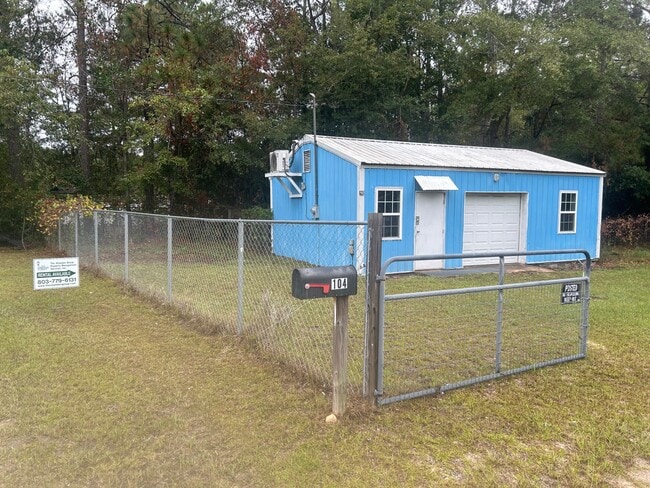
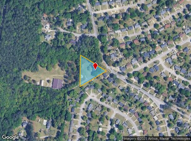
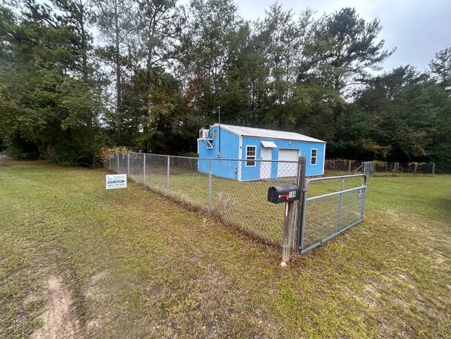
Property Record
3953 Trotter Rd, Columbia, SC 29209
Current Lease Availabilities
NEARBY LISTINGS FOR SALE OR LEASE
-
-
View all Columbia listings for lease on LoopNet.com
Property Detail
3953 Trotter Rd
22008-01-10
Garners Ferry
Commercialnec
309.3X73.6X237.3X317.8 #SU #PR W-44 RB290-2017
X
Richland
45079C0382L
South Carolina
2025
1.01 AC
2024
Southeast Columbia
011606
Columbia
1,576 SF
Columbia, SC
DEMOGRAPHICS near 3953 Trotter Rd
1 Mile
3 Mile
5 Mile
2024 Total Population
4,944
25,672
61,656
2029 Population
5,139
26,706
63,838
Pop Growth 2024-2029
+ 3.94%
+ 4.03%
+ 3.54%
Average Age
39
38
37
2024 Total Households
1,947
9,723
22,594
HH Growth 2024-2029
+ 3.95%
+ 4.17%
+ 3.88%
Median Household Inc
$54,812
$57,322
$62,609
Avg Household Size
2.50
2.40
2.30
2024 Avg HH Vehicles
2.00
2.00
2.00
Median Home Value
$171,572
$186,836
$238,858
Median Year Built
1988
1991
1988
Nearby Places
- Restaurants
- Banks
- Shops
- Fitness
- Groceries
PUBLIC TRANSPORTATION
COMMUTER RAIL
Columbia Amtrak Station (Silver Star - Amtrak)
DRIVE
WALK
Distance
Columbia Amtrak Station (Silver Star - Amtrak)
20 min
10.0 mi
AIRPORT
Columbia Metro
DRIVE
WALK
Distance
Columbia Metro
34 min
19.8 mi
Freight Ports
North Charleston Terminal
DRIVE
WALK
Distance
North Charleston Terminal
128 min
111.2 mi
Nearby Properties
Address
Land Use
TOTAL SIZE
Lot Size
Zoning
Address
Land Use
TOTAL SIZE
Lot Size
Zoning
294,105 SF
19 AC
RG-2
Address
Land Use
TOTAL SIZE
Lot Size
Zoning
212,787 SF
26.93 AC
C-3
Address
Land Use
TOTAL SIZE
Lot Size
Zoning
56.15 AC
PDD
Address
Land Use
TOTAL SIZE
Lot Size
Zoning
16,140 SF
1.84 AC
PD
Address
Land Use
TOTAL SIZE
Lot Size
Zoning
255,848 SF
19.98 AC
RM-HD
Address
Land Use
TOTAL SIZE
Lot Size
Zoning
84,788 SF
5.83 AC
RM-HD
Address
Land Use
TOTAL SIZE
Lot Size
Zoning
60,772 SF
9.30 AC
GC
Address
Land Use
TOTAL SIZE
Lot Size
Zoning
51,516 SF
9.12 AC
GC
Address
Land Use
TOTAL SIZE
Lot Size
Zoning
92,918 SF
10.39 AC
M-1
Address
Land Use
TOTAL SIZE
Lot Size
Zoning
30,162 SF
3.46 AC
RS-MD
Address
Land Use
TOTAL SIZE
Lot Size
Zoning
114,660 SF
11.02 AC
RM-HD
Address
Land Use
TOTAL SIZE
Lot Size
Zoning
19,925 SF
4.34 AC
RS-LD
Address
Land Use
TOTAL SIZE
Lot Size
Zoning
91,726 SF
9.54 AC
RM-HD
Address
Land Use
TOTAL SIZE
Lot Size
Zoning
58,000 SF
5.73 AC
C-3
Address
Land Use
TOTAL SIZE
Lot Size
Zoning
13,888 SF
2 AC
PD
Address
Land Use
TOTAL SIZE
Lot Size
Zoning
84,212 SF
6.88 AC
RG-1A
Address
Land Use
TOTAL SIZE
Lot Size
Zoning
15,638 SF
1.87 AC
GC
Address
Land Use
TOTAL SIZE
Lot Size
Zoning
61,682 SF
4.92 AC
C-3
Address
Land Use
TOTAL SIZE
Lot Size
Zoning
25,184 SF
31 AC
M-1
Address
Land Use
TOTAL SIZE
Lot Size
Zoning
4,966 SF
2.18 AC
LI
Address
Land Use
TOTAL SIZE
Lot Size
Zoning
7,642 SF
2.42 AC
GC
Address
Land Use
TOTAL SIZE
Lot Size
Zoning
17,182 SF
2.89 AC
M-1
Address
Land Use
TOTAL SIZE
Lot Size
Zoning
9,591 SF
14.68 AC
RU
Address
Land Use
TOTAL SIZE
Lot Size
Zoning
12,438 SF
8.02 AC
RS-LD
Address
Land Use
TOTAL SIZE
Lot Size
Zoning
11,688 SF
1.21 AC
GC
Address
Land Use
TOTAL SIZE
Lot Size
Zoning
7,841 SF
2.99 AC
GC
Address
Land Use
TOTAL SIZE
Lot Size
Zoning
3,924 SF
12.41 AC
RU
Address
Land Use
TOTAL SIZE
Lot Size
Zoning
10,868 SF
1.79 AC
GC
Address
Land Use
TOTAL SIZE
Lot Size
Zoning
13.40 AC
C-3
Address
Land Use
TOTAL SIZE
Lot Size
Zoning
18.81 AC
PD
The World's #1 Commercial Real Estate Marketplace
Connect with us
© 2025 CoStar Group
The information above has been obtained from sources believed reliable. While we do not doubt its accuracy we have not verified it and make no guarantee, warranty or representation about it. It is your responsibility to independently confirm its accuracy and completeness. Any projections, opinions, assumptions, or estimates used are for example only and do not represent the current or future performance of the property. The value of this transaction to you depends on tax and other factors which should be evaluated by your tax, financial, and legal advisors. You and your advisors should conduct a careful, independent investigation of the property to determine to your satisfaction the suitability of the property for your needs.