Property Record
1040 E Highway 71 E, Bastrop, TX 78602
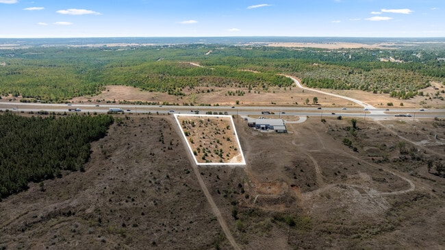


This Property Is For Sale
Property Detail
1040 E Highway 71 E
Austin-Round Rock-San Marcos, TX
BASTROP HILLS HOMESITES, SECTION 1, LOT 44, ACRES 1.79
63071
Bastrop
Recreationalacreage
Texas
B and X Area of moderate flood hazard, usually the area between the limits of the 100-year and 500-year floods.
44
2024
1.79 AC
2025
Bastrop County
950401
Austin
NEARBY LISTINGS FOR SALE OR LEASE
DEMOGRAPHICS near 1040 E Highway 71 E
1 mile
3 mile
5 mile
2024 Total Population
568
6,729
15,630
2029 Population
655
7,780
18,002
Pop Growth 2024-2029
+ 15.32%
+ 15.62%
+ 15.18%
Average Age
43
43
42
2024 Total Households
222
2,700
6,098
HH Growth 2024-2029
+ 15.32%
+ 16.00%
+ 15.63%
Median Household Inc
$75,266
$83,312
$80,545
Avg Household Size
2.50
2.50
2.50
2024 Avg HH Vehicles
2.00
2.00
2.00
Median Home Value
$340,983
$366,322
$358,175
Median Year Built
2010
2008
2005
Nearby Places
Map Layers
Map Styles
 Street
 Aerial
Transit
 Traffic
 Biking
Places
Listings with unknown addresses are not visible on the map
- Restaurants
- Banks
- Shops
- Fitness
- Groceries
PUBLIC TRANSPORTATION
AIRPORT
Austin-Bergstrom International
Drive
Walk
Distance
Austin-Bergstrom International
32 min
21.6 mi
Freight Ports
Calhoun Port
Drive
Walk
Distance
Calhoun Port
170 min
144.0 mi
Nearby Properties
Address
Land Use
TOTAL SIZE
Lot Size
Zoning
Address
Land Use
TOTAL SIZE
Lot Size
Zoning
22.60 AC
Address
Land Use
TOTAL SIZE
Lot Size
Zoning
120,000 SF
12.54 AC
Address
Land Use
TOTAL SIZE
Lot Size
Zoning
83,994 SF
7.83 AC
Address
Land Use
TOTAL SIZE
Lot Size
Zoning
125,000 SF
11.98 AC
Address
Land Use
TOTAL SIZE
Lot Size
Zoning
87,953 SF
8.06 AC
Address
Land Use
TOTAL SIZE
Lot Size
Zoning
86,427 SF
23.38 AC
Address
Land Use
TOTAL SIZE
Lot Size
Zoning
49,508 SF
6.58 AC
Address
Land Use
TOTAL SIZE
Lot Size
Zoning
20 AC
Address
Land Use
TOTAL SIZE
Lot Size
Zoning
40,261 SF
15 AC
Address
Land Use
TOTAL SIZE
Lot Size
Zoning
33,105 SF
21.89 AC
Address
Land Use
TOTAL SIZE
Lot Size
Zoning
125,948 SF
12.76 AC
Address
Land Use
TOTAL SIZE
Lot Size
Zoning
54,856 SF
4.15 AC
Address
Land Use
TOTAL SIZE
Lot Size
Zoning
37,058 SF
4.14 AC
Address
Land Use
TOTAL SIZE
Lot Size
Zoning
43,956 SF
6.29 AC
Address
Land Use
TOTAL SIZE
Lot Size
Zoning
33,183 SF
33.48 AC
Address
Land Use
TOTAL SIZE
Lot Size
Zoning
32,828 SF
4.02 AC
Address
Land Use
TOTAL SIZE
Lot Size
Zoning
97,631 SF
14.03 AC
Address
Land Use
TOTAL SIZE
Lot Size
Zoning
10,464 SF
108.47 AC
Address
Land Use
TOTAL SIZE
Lot Size
Zoning
17,882 SF
3.85 AC
Address
Land Use
TOTAL SIZE
Lot Size
Zoning
71,848 SF
7.27 AC
Address
Land Use
TOTAL SIZE
Lot Size
Zoning
28,080 SF
2.82 AC
Address
Land Use
TOTAL SIZE
Lot Size
Zoning
28.45 AC
Address
Land Use
TOTAL SIZE
Lot Size
Zoning
34,009 SF
8.02 AC
Address
Land Use
TOTAL SIZE
Lot Size
Zoning
156,609 SF
9.62 AC
Address
Land Use
TOTAL SIZE
Lot Size
Zoning
55,344 SF
4 AC
Address
Land Use
TOTAL SIZE
Lot Size
Zoning
52,973 SF
5.01 AC
Address
Land Use
TOTAL SIZE
Lot Size
Zoning
39,300 SF
3.50 AC
Address
Land Use
TOTAL SIZE
Lot Size
Zoning
63,104 SF
5.70 AC
Address
Land Use
TOTAL SIZE
Lot Size
Zoning
18,886 SF
2.29 AC
Address
Land Use
TOTAL SIZE
Lot Size
Zoning
23,600 SF
2.57 AC
The World's #1 Commercial Real Estate Marketplace
Connect with us
© 2026 CoStar Group
The information above has been obtained from sources believed reliable. While we do not doubt its accuracy we have not verified it and make no guarantee, warranty or representation about it. It is your responsibility to independently confirm its accuracy and completeness. Any projections, opinions, assumptions, or estimates used are for example only and do not represent the current or future performance of the property. The value of this transaction to you depends on tax and other factors which should be evaluated by your tax, financial, and legal advisors. You and your advisors should conduct a careful, independent investigation of the property to determine to your satisfaction the suitability of the property for your needs.