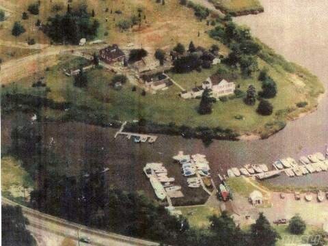
Property Record
1040 Flanders Rd, Riverhead, NY 11901

NEARBY LISTINGS FOR SALE OR LEASE
Property Detail
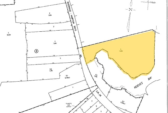
1040 Flanders Rd
0900-145-00-05-00-001-000
89 BOR N/CAC PER SURVEY
Multifamilydwelling
Suffolk
AE
New York
36103C0488H
1
0
4.56 AC
2024
Eastern Suffolk
190405
Long Island (New York)
9,478 SF
Nassau County-Suffolk County, NY
DEMOGRAPHICS near 1040 Flanders Rd
1 Mile
3 Mile
5 Mile
2024 Total Population
4,754
16,986
37,799
2029 Population
4,781
16,923
37,672
Pop Growth 2024-2029
+ 0.57%
(0.37%)
(0.34%)
Average Age
37
38
42
2024 Total Households
1,399
5,486
13,613
HH Growth 2024-2029
+ 0.64%
(0.66%)
(0.62%)
Median Household Inc
$90,773
$77,033
$75,084
Avg Household Size
3.20
2.90
2.70
2024 Avg HH Vehicles
2.00
2.00
2.00
Median Home Value
$388,946
$381,765
$479,155
Median Year Built
1975
1973
1980
Nearby Places
Map Layers
Map Styles
 Street
 Aerial
- Restaurants
- Banks
- Shops
- Fitness
- Groceries
PUBLIC TRANSPORTATION
COMMUTER RAIL
Riverhead Station (Greenport Branch - Long Island Rail Road)
DRIVE
WALK
Distance
Riverhead Station (Greenport Branch - Long Island Rail Road)
6 min
3.0 mi
Hampton Bays Station (Montauk Branch - Long Island Rail Road)
DRIVE
WALK
Distance
Hampton Bays Station (Montauk Branch - Long Island Rail Road)
10 min
6.3 mi
AIRPORT
Long Island MacArthur
DRIVE
WALK
Distance
Long Island MacArthur
47 min
30.0 mi
Freight Ports
Port of New Haven
DRIVE
WALK
Distance
Port of New Haven
153 min
62.7 mi
Nearby Properties
Address
Land Use
TOTAL SIZE
Lot Size
Zoning
Address
Land Use
TOTAL SIZE
Lot Size
Zoning
233,668 SF
82.70 AC
CR200
Address
Land Use
TOTAL SIZE
Lot Size
Zoning
49,680 SF
1.30 AC
8
Address
Land Use
TOTAL SIZE
Lot Size
Zoning
51.70 AC
R15
Address
Land Use
TOTAL SIZE
Lot Size
Zoning
8,100 SF
4.31 AC
LI40
Address
Land Use
TOTAL SIZE
Lot Size
Zoning
222 AC
H2O
Address
Land Use
TOTAL SIZE
Lot Size
Zoning
197.50 AC
Address
Land Use
TOTAL SIZE
Lot Size
Zoning
151,290 SF
6.17 AC
08
Address
Land Use
TOTAL SIZE
Lot Size
Zoning
81.70 AC
R60
Address
Land Use
TOTAL SIZE
Lot Size
Zoning
36,883 SF
14.80 AC
R15
Address
Land Use
TOTAL SIZE
Lot Size
Zoning
23,743 SF
5.80 AC
MTL
Address
Land Use
TOTAL SIZE
Lot Size
Zoning
485.30 AC
CR60
Address
Land Use
TOTAL SIZE
Lot Size
Zoning
29.72 AC
R20
Address
Land Use
TOTAL SIZE
Lot Size
Zoning
68.90 AC
H2O
Address
Land Use
TOTAL SIZE
Lot Size
Zoning
31,462 SF
5.74 AC
LI200
Address
Land Use
TOTAL SIZE
Lot Size
Zoning
403.50 AC
CR200
Address
Land Use
TOTAL SIZE
Lot Size
Zoning
3,468 SF
17.70 AC
CR60
Address
Land Use
TOTAL SIZE
Lot Size
Zoning
314.17 AC
OSC
Address
Land Use
TOTAL SIZE
Lot Size
Zoning
108,504 SF
31.20 AC
SC
Address
Land Use
TOTAL SIZE
Lot Size
Zoning
4,410 SF
1 AC
OD
Address
Land Use
TOTAL SIZE
Lot Size
Zoning
3,362 SF
3 AC
RWB
Address
Land Use
TOTAL SIZE
Lot Size
Zoning
2.50 AC
OSC
Address
Land Use
TOTAL SIZE
Lot Size
Zoning
28.97 AC
R40
Address
Land Use
TOTAL SIZE
Lot Size
Zoning
73,651 SF
8.50 AC
3
Address
Land Use
TOTAL SIZE
Lot Size
Zoning
20.50 AC
CR120
Address
Land Use
TOTAL SIZE
Lot Size
Zoning
14,520 SF
21.20 AC
04
Address
Land Use
TOTAL SIZE
Lot Size
Zoning
274.40 AC
05
Address
Land Use
TOTAL SIZE
Lot Size
Zoning
261.40 AC
CR60
Address
Land Use
TOTAL SIZE
Lot Size
Zoning
586.10 AC
OSC
Address
Land Use
TOTAL SIZE
Lot Size
Zoning
10,500 SF
1.45 AC
LI40
Address
Land Use
TOTAL SIZE
Lot Size
Zoning
12,570 SF
1.63 AC
8
The World's #1 Commercial Real Estate Marketplace
Connect with us
© 2026 CoStar Group
The information above has been obtained from sources believed reliable. While we do not doubt its accuracy we have not verified it and make no guarantee, warranty or representation about it. It is your responsibility to independently confirm its accuracy and completeness. Any projections, opinions, assumptions, or estimates used are for example only and do not represent the current or future performance of the property. The value of this transaction to you depends on tax and other factors which should be evaluated by your tax, financial, and legal advisors. You and your advisors should conduct a careful, independent investigation of the property to determine to your satisfaction the suitability of the property for your needs.