Property Record
1040 High St, Hanover, PA 17331
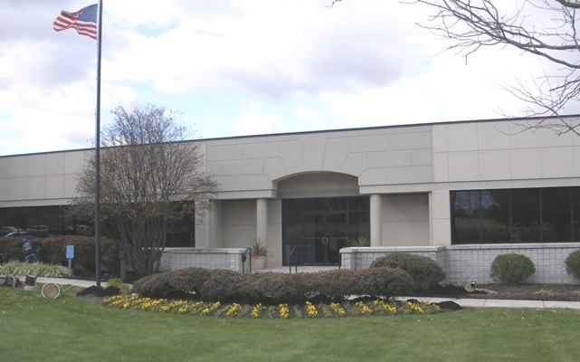

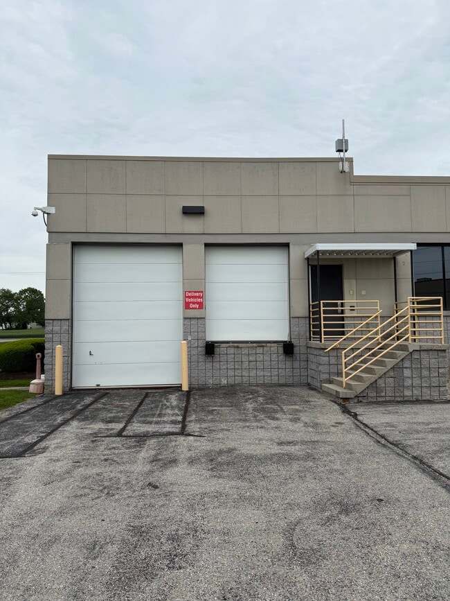

This Property Is For Sale
Current Lease Availabilities
Property Detail
1040 High St
Officebuilding
York
CM
Pennsylvania
B and X Area of moderate flood hazard, usually the area between the limits of the 100-year and 500-year floods.
2.55 AC
2025
York County
2025
Philadelphia
022300
York-Hanover, PA
17,469 SF
67-000-12-0132.A0-00000
NEARBY LISTINGS FOR SALE OR LEASE
DEMOGRAPHICS near 1040 High St
1 mile
3 mile
5 mile
2025 Total Population
6,078
40,198
68,666
2030 Population
6,243
41,374
70,920
Pop Growth 2025-2030
+ 2.71%
+ 2.93%
+ 3.28%
Average Age
45
42
43
2025 Total Households
2,841
16,769
27,603
HH Growth 2025-2030
+ 2.89%
+ 3.07%
+ 3.41%
Median Household Inc
$68,931
$69,651
$74,333
Avg Household Size
2.10
2.30
2.40
2025 Avg HH Vehicles
2.00
2.00
2.00
Median Home Value
$227,055
$229,146
$245,841
Median Year Built
1967
1969
1979
Nearby Places
Map Layers
Map Styles
 Street
 Aerial
Layers
 Traffic
 Biking
Places
Listings with unknown addresses are not visible on the map
- Restaurants
- Banks
- Shops
- Fitness
- Groceries
PUBLIC TRANSPORTATION
AIRPORT
Harrisburg International
Drive
Walk
Distance
Harrisburg International
68 min
46.3 mi
Freight Ports
Port of Baltimore
Drive
Walk
Distance
Port of Baltimore
80 min
52.4 mi
Nearby Properties
Address
Land Use
TOTAL SIZE
Lot Size
Zoning
Address
Land Use
TOTAL SIZE
Lot Size
Zoning
65,738 SF
89.96 AC
RS
Address
Land Use
TOTAL SIZE
Lot Size
Zoning
35.99 AC
Address
Land Use
TOTAL SIZE
Lot Size
Zoning
2,331 SF
104.05 AC
CI
Address
Land Use
TOTAL SIZE
Lot Size
Zoning
93.98 AC
CI
Address
Land Use
TOTAL SIZE
Lot Size
Zoning
1,297.86 AC
I
Address
Land Use
TOTAL SIZE
Lot Size
Zoning
23,050 SF
26.70 AC
CM
Address
Land Use
TOTAL SIZE
Lot Size
Zoning
109.27 AC
CI
Address
Land Use
TOTAL SIZE
Lot Size
Zoning
12.32 AC
CI
Address
Land Use
TOTAL SIZE
Lot Size
Zoning
129,869 SF
44.23 AC
ID
Address
Land Use
TOTAL SIZE
Lot Size
Zoning
190,175 SF
20.98 AC
ID
Address
Land Use
TOTAL SIZE
Lot Size
Zoning
24.39 AC
CI
Address
Land Use
TOTAL SIZE
Lot Size
Zoning
195,797 SF
20.31 AC
CM
Address
Land Use
TOTAL SIZE
Lot Size
Zoning
360,608 SF
46.91 AC
ID
Address
Land Use
TOTAL SIZE
Lot Size
Zoning
49,736 SF
20.73 AC
CM
Address
Land Use
TOTAL SIZE
Lot Size
Zoning
137,390 SF
17.47 AC
M
Address
Land Use
TOTAL SIZE
Lot Size
Zoning
116.36 AC
A
Address
Land Use
TOTAL SIZE
Lot Size
Zoning
16,669 SF
1.51 AC
Address
Land Use
TOTAL SIZE
Lot Size
Zoning
386,528 SF
2.35 AC
ID
Address
Land Use
TOTAL SIZE
Lot Size
Zoning
143,998 SF
21.94 AC
I
Address
Land Use
TOTAL SIZE
Lot Size
Zoning
207,780 SF
16.72 AC
CM
Address
Land Use
TOTAL SIZE
Lot Size
Zoning
13.23 AC
CI
Address
Land Use
TOTAL SIZE
Lot Size
Zoning
149,760 SF
22.93 AC
I
Address
Land Use
TOTAL SIZE
Lot Size
Zoning
9.80 AC
CI
Address
Land Use
TOTAL SIZE
Lot Size
Zoning
13.32 AC
CI
Address
Land Use
TOTAL SIZE
Lot Size
Zoning
60,590 SF
11.04 AC
IND
Address
Land Use
TOTAL SIZE
Lot Size
Zoning
67,650 SF
7.42 AC
RS
Address
Land Use
TOTAL SIZE
Lot Size
Zoning
376,800 SF
26.23 AC
ID
Address
Land Use
TOTAL SIZE
Lot Size
Zoning
271,646 SF
22.51 AC
IND
Address
Land Use
TOTAL SIZE
Lot Size
Zoning
Address
Land Use
TOTAL SIZE
Lot Size
Zoning
291,626 SF
39.16 AC
ID
The World's #1 Commercial Real Estate Marketplace
Connect with us
© 2026 CoStar Group
The information above has been obtained from sources believed reliable. While we do not doubt its accuracy we have not verified it and make no guarantee, warranty or representation about it. It is your responsibility to independently confirm its accuracy and completeness. Any projections, opinions, assumptions, or estimates used are for example only and do not represent the current or future performance of the property. The value of this transaction to you depends on tax and other factors which should be evaluated by your tax, financial, and legal advisors. You and your advisors should conduct a careful, independent investigation of the property to determine to your satisfaction the suitability of the property for your needs.